Brought to you by R.E. Graves Heating & Air Conditioning
1PM Update: The NWS has expanded the Flash Flood Watch southward to include all of Southern MD.
Hurricane Ida was finally downgraded from CAT 4 Hurricane status to Tropical Storm status this morning as the system gradually weakens overland. While the winds are diminishing some, we are still seeing the Tropical Storm bring widespread flooding issues across the lower Mississippi Delta. The remnants of Ida will eventually work up into the Mid-Atlantic by late Tuesday into Wednesday and Thursday. The remnants of Ida will bring with it a lot of tropical moisture and a flash flooding threat for much of our region. Highlighted below is the overall weather setup for the middle of the week. Our region has already been highlighted as having an Elevated to Significant threat of flooding on Wednesday. The National Weather Service normally does not issue such aggressive outlooks 2-3 days in advance. This just speaks volumes to the significant flooding risk that will exist.

Rain will begin to move into our region late Tuesday evening. Anytime after 3/4PM will be fair game for the initial showers to work through. By sunset, we will likely see areas of heavy rain develop, and move through the region. These pockets of heavy rain will continue throughout Wednesday, and may even linger into Thursday. The placement of the heaviest rain will depend largely on the exact track that the remnants of Ida take. It will be hard to determine where these heavy pockets will set up until we actually see them developing on the radar. With that in mind, I think many of us are prone to seeing those pockets of heavier rain move through.
Our Futurecast model is not entirely in range yet to capture the whole event. The model currently only goes out through Wednesday afternoon. Even still, we can see how the depicts those pockets of heavy rain setting up across the region.
As mentioned above, the rainfall totals we see will be heavily dependent on the exact track we see the system take. A track further to the north would suggest the heaviest falling northwest of DC. A track further south would suggest the heaviest potentially falling over our region. It is hard to say which track will win out. Nevertheless, a corridor of heavy rain will set up, and some spots under that corridor could see 3-6″+ of rain. Shown below is the National Weather Service forecast rain amounts. They currently favor a more northerly solution, which is totally possible. This would place that zone of 3-6″+ NW of DC, through parts of Western MD and Central PA. This setup would still give us impactful rain totals of 2-4″.

Our long-range models, like the one shown below, are currently in agreement with the NWS forecast shown above. The model suggests that as much as 3-5″ may fall north of DC, with 1-4″ amounts across Southern MD and the Northern Neck. With that said, there are several different models we look at, and all of them show something different. Some keep the heaviest rain to the north, others bring it south. What is constant with all of them is the likelihood that everyone WILL see rain, and a corridor of heavier rain WILL set up. The big question is– where does that corridor set up?

With all of this in mind, the National Weather Service has already issued a Flash Flood Watch for much of the Mid-Atlantic. This Watch is primarily focused on northern and interior areas, which lines of with where they are forecasting the heaviest rain. With this said, this DOES NOT MEAN that Southern MD and the Northern Neck will not see heavy rain or flooding issues. That threat is very much alive. What this does mean is that the NWS is currently highlighting the areas that could see the most. I would not be surprised to see this Watch expanded further southward at some point.
UPDATE: The Flash Flood Watch was indeed extended southward for SoMD. You can see this on the second slide.
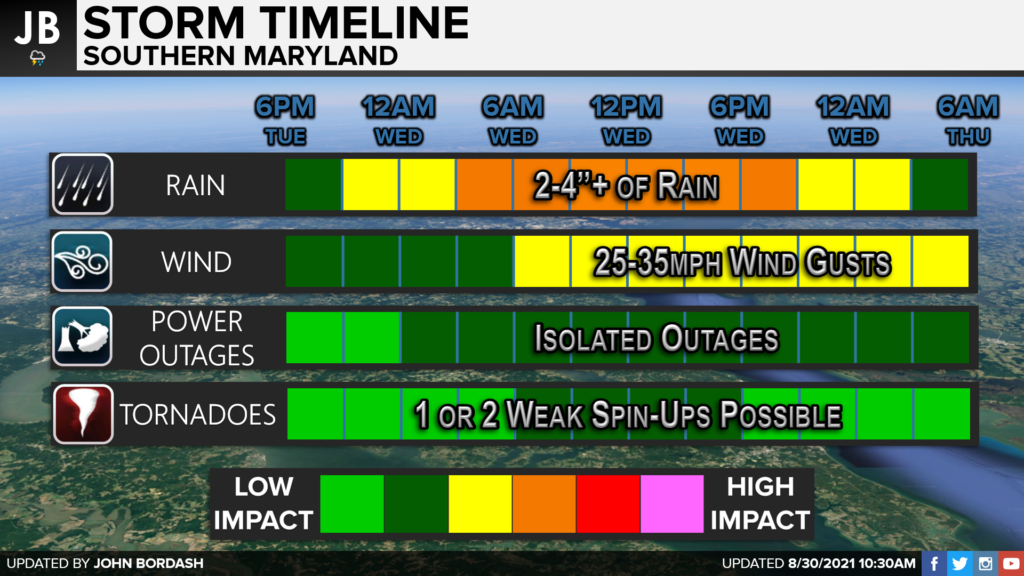
All in all, we are likely to see a moderate impact event across the Mid-Atlantic as the remnants of Ida move through on Tuesday night, Wednesday and Thursday. We could see widespread flooding issues as 2-4″+ of rain looks possible. Gusty winds are also possible, but I am not worried about the power outage threat at the moment. With decaying tropical systems, we also have to discuss the potential for brief spin-up tornadoes. We could see 1 or 2 weak tornadoes spin up in our region Wednesday afternoon and evening. I don’t think the threat is as high as it was with Elsa earlier this Summer, or with Isaias last year.

It will be important to stay with JB Weather for the latest information on Ida, and the impacts here in Southern Maryland later this week. You can always access my forecasts and updates here on the website, on Facebook, on Twitter, and on YouTube. JB Weather is Southern Maryland’s Weather Leader, and I am working around the clock to keep you ahead of the storm!
-JB

R.E. Graves Heating & Air Conditioning is a ⭐️⭐️⭐️⭐️⭐️ HVAC Contractor serving St Mary’s & Calvert. Just mention JB Weather to Save 20% off your next Heating repair bill when you Book now! regraveshvac.net/jbweather20off
1 thought on “Significant Flood Risk Mid-Week with Ida’s Remnants”
Comments are closed.


[…] [ August 30, 2021 ] Significant Flood Risk Mid-Week with Ida’s Remnants Top Stories […]