Brought to you by Cedar Point Federal Credit Union
We have seen rain showers move through the region today as a complex set of systems moves closer towards our region. So far, the rain we have seen today has not been too bad, with only a few areas of moderate rain. That will look to change tonight. A complex setup that could bring a wide variety of impacts. I will try my best to break all of this down into as simple of terms as I can.
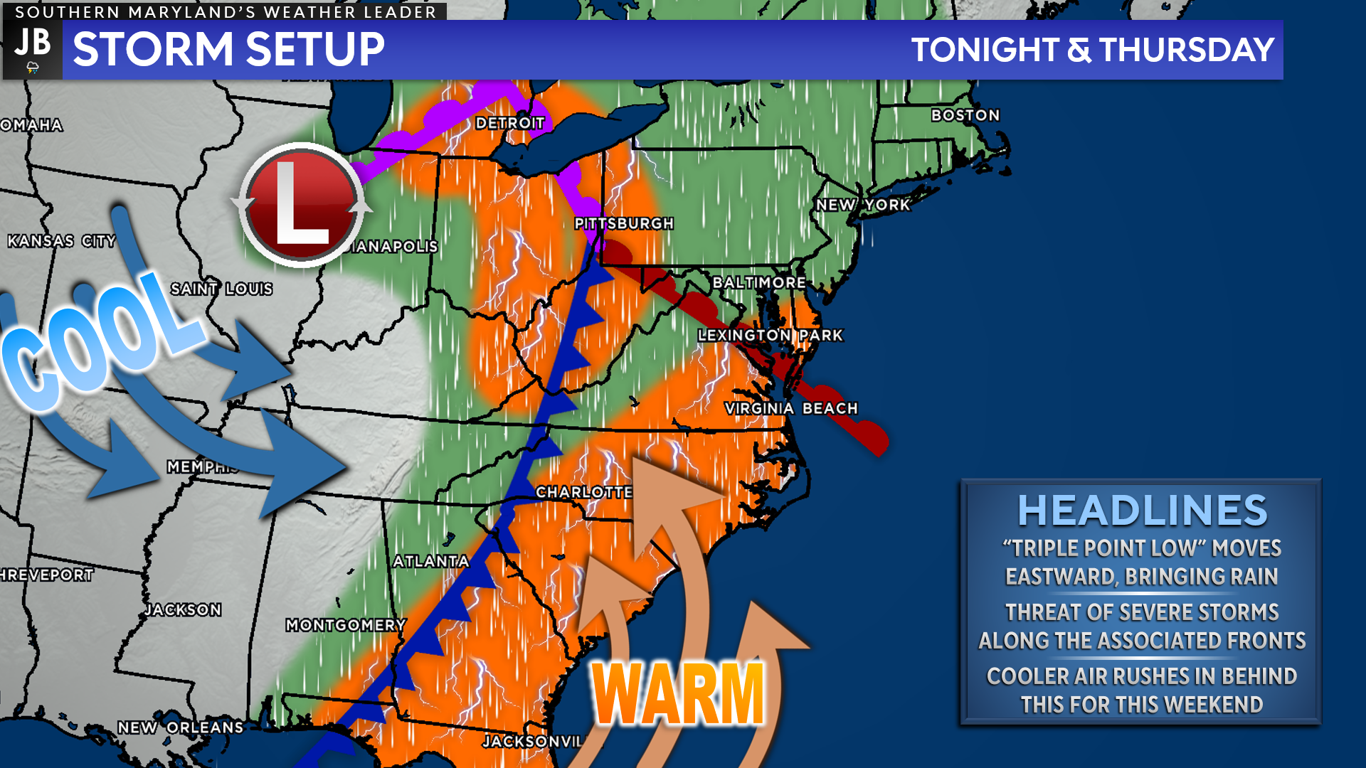
The complex weather setup we have at hand revolves around a phenomenon called a “triple point low.” A triple point low is the point at which three different types of fronts, a cold front, a warm front, and an occluded front (a mix of the former two) all come together. In laymen’s terms, this can set up rather complex weather situations with cold and warm air fighting for dominance. My apologies for this somewhat complicated explanation.
For our region, we will see the warm lift northward this evening– ushering in warmer temperatures tonight. With this warm front will come a swath of rain, which could be heavy at times. The cold front will then work though on Thursday, from west to east. This cold front will also bring rain with it, and may utilize the warm & moist air left behind from the warm front to develop some storms. All of this mess will eventually work through the region by tomorrow evening, ushering in some clearing.
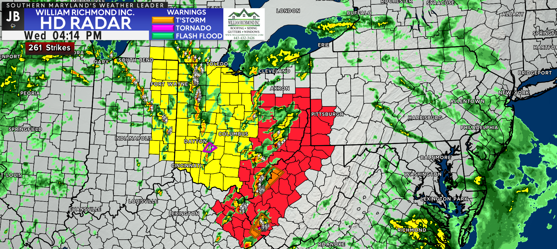
Ahead of the warm front, we have just been dealing with rain showers in our region. However, back to the west along the occluded front, we have Severe Thunderstorm Watches (yellow) and Tornado Watches (red) in effect across the Ohio Valley. That is where the severe weather threat will continue to be focused through tonight.
Our Chesapeake’s Bounty Futurecast shows that we will see rain showers increase in coverage by this evening. As the initial warm front lifts northward, we will see a swath of rather heavy rain work through our region between about 10pm and 5am. It is possible that we could see 1 or 2 embedded thunderstorms within this band before we see a brief period of clearing just after sunrise.
Overnight, we may see up to three-quarters of an inch of rain fall. With that said, it is possible that some localized locations could see up to 1-2″ of rain if they get caught under a slow-moving band of heavy rain. Temperatures will likely warm overnight as warm air surges northward as the warm front travels north.
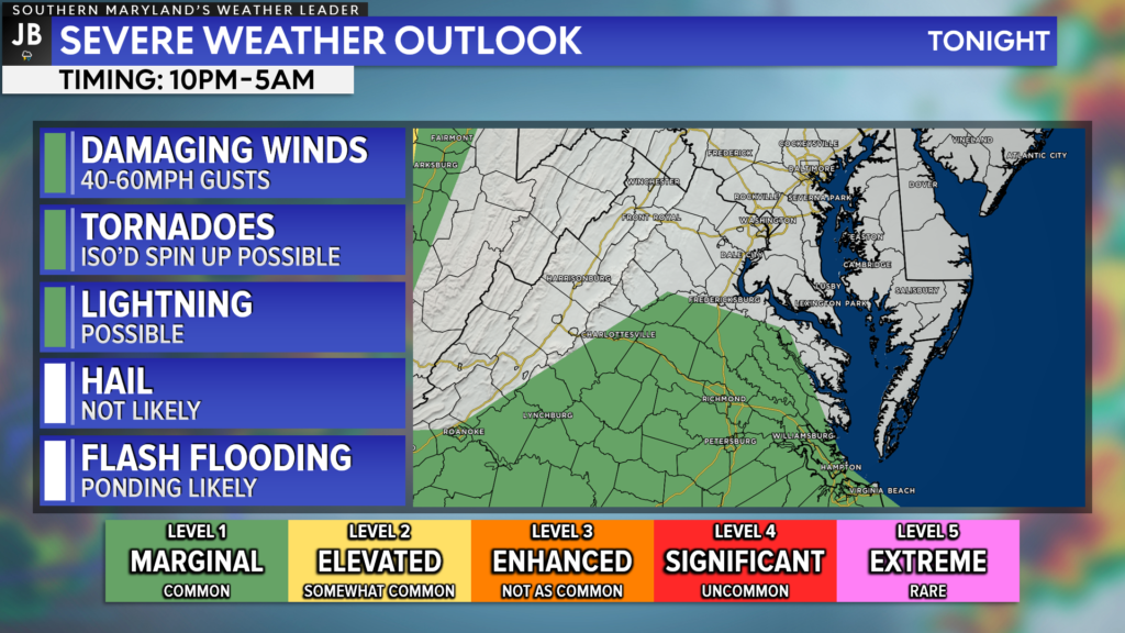
With the potential for embedded thunderstorms also comes the risk of severe weather. The Storm Prediction Center will be watching our region closely to see if any thunderstorms do turn severe with the round of rain associated with the warm front tonight. Right now, the Level 1 “Marginal Risk” remains to our south. However, we could see that change to include our area. While this threat is not all that high, it does highlight the non-zero wind and tornado threat tonight.
I am not expecting a widespread severe weather outbreak. With that said though, we will have a tremendous amount of wind energy for storms to potentially tap into. What will likely prevent many storms from developing is a lack of storm energy at the surface. So, that means that we likely will NOT see widespread storms tonight, just heavy rain. However, if 1 or 2 storms are able to develop, they would have a decent amount of wind energy to tap into. It is for that reason that we are highlighting a threat of 40-60mph wind gusts and the potential for 1 or 2 storms to try to rotate overnight.
Again, this threat is not high. But, it is non-zero and I am obligated to tell you about it.
After tonight’s round of rain, we are likely to see a brief break in the rain early tomorrow morning, around sunrise. However, as that cold front heads eastward, we will see rain redevelop across the region by mid-morning. The rain tomorrow will primarily focus on areas east of I-95 as the cold front slowly marches through. Additional periods of heavy rain and embedded thunderstorms are possible late tomorrow morning and tomorrow afternoon before clearing by the evening hours.
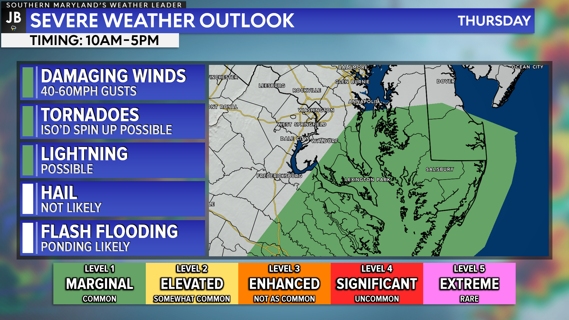
Tomorrow, our region will be under a Level 1 “Marginal Risk” of severe weather. Since we will have additional heating tomorrow, with temperatures getting into the 70s, we will have increased storm energy in the atmosphere. This may work with the increased wind energy to allow for any embedded thunderstorms to go severe. The severe threats would be the same as they are with tonight’s storms. Again, I am not expecting a severe weather outbreak tomorrow, but 1 or 2 severe storms are possible.
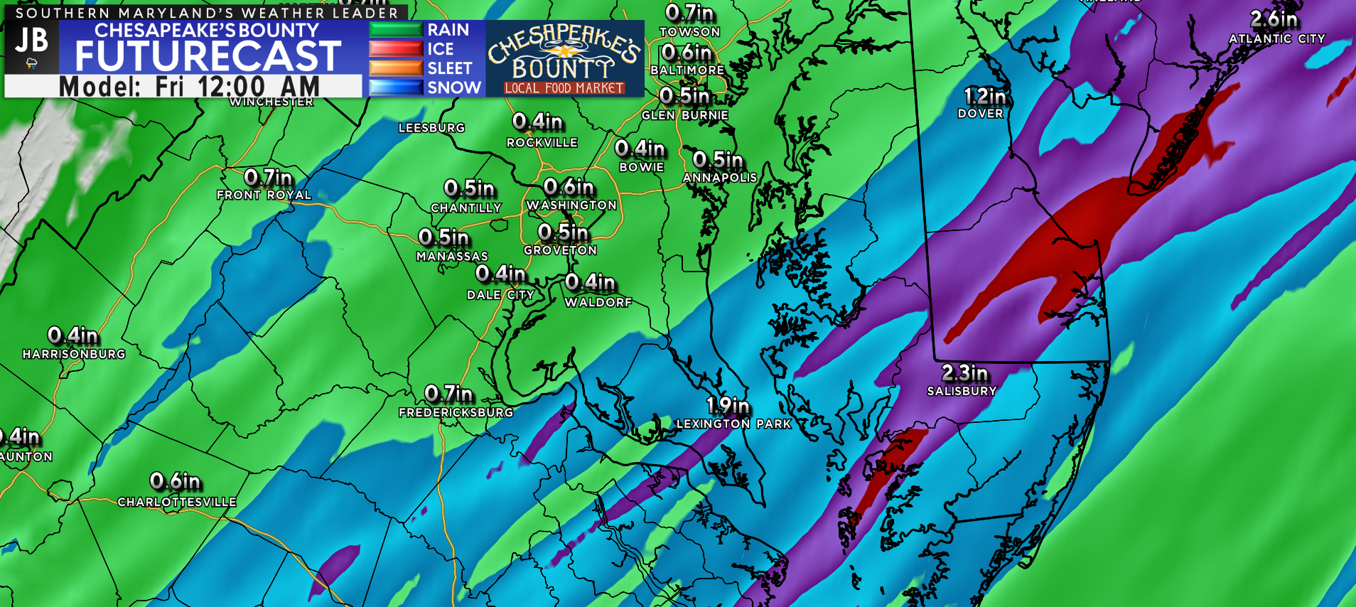
Over the next 24 hours, our region could see an additional inch or so of rain. Futurecast shows that the highest rain totals will be found southeast of DC. While the model may not get the exact placement of the rain totals right, it does show the potential for 1-2″+ amounts (shown by the blue and purple shadings, respectively) in our region. This will likely lead to ponding, and may even lead to 1 or 2 communities seeing some minor flooding.
In Summary
All-in-all, we have a complex weather setup over the next 24 hours. A series of fronts will bring heavy rain and the threat of storms to the region. While a widespread severe weather outbreak is unlikely, 1 or 2 storms could turn severe overnight tonight and again tomorrow. Our region could see as much as 1-2″ of rain before all is said and done. Plan on a wet 24 hours with only a few breaks in the action.
Stay with JB Weather for the latest information on Southern Maryland weather. You can always access my forecasts and updates here on the website, on Facebook, on Twitter, and on YouTube.
-JB
Cedar Point has been providing trusted banking, lending and personal finance solutions to the Southern Maryland Community since 1945. Visit the credit union at any of its 6 locations in St. Mary’s, Charles and Calvert counties or online at www.cpfcu.com.
John Bordash
View More PostsJB Weather forecaster John Bordash is working around the clock to provide Southern Maryland, and neighboring communities, with accurate and reliable weather information.

1 thought on “Storms, Heavy Rain Possible Overnight and Into Thursday”
Comments are closed.
[…] [ March 23, 2022 ] Storms, Heavy Rain Possible Overnight and Into Thursday Severe Weather […]