Brought to you by Cedar Point Federal Credit Union
After a quiet weather day today, we will quickly see conditions turn around tomorrow! On Saturday, a high-impact storm system will be traveling northward along an incoming cold front. The combination of the front and developing system will offer a wide variety of impacts to our region throughout the day tomorrow.
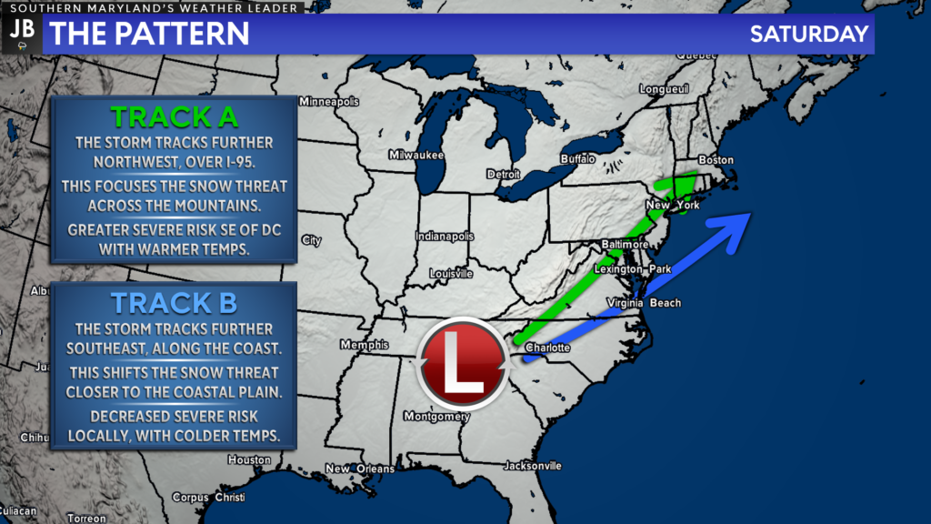
The Setup & Uncertainty: This forecast has a high level of uncertainty, which makes it even harder to convey the multiple threats at hand. The biggest question is, how far northwest does the storm system track? A track further northwest limits the snow threat along the coastal plain and increases the severe risk. The inverse is true if the storm tracks further southeast.
Additional uncertainty comes when determining how fast the cold air arrives behind the system and the cold front. Suppose the cold air arrives quicker while precipitation is still around. In that case, more areas could potentially switch over to snow by midday Saturday.
Timing: We will see cloud cover increase late this evening as moisture with our system begins to lift northward. Rain showers should begin to break out after midnight, with a more widespread swath of moderate to heavy rain moving through our region by daybreak. Within this band of heavy rain, we could see embedded thunderstorms develop.
Cold air will rush in from the northwest by mid-morning and gradually switch areas over to snow. Zones northwest of DC should switch to snow by mid-morning. After heavy rain early Saturday morning, a transition to sleet and then to snow looks possible in Southern MD by late-morning.
As cold air filters into the region, winds will pick up from the northwest. This northwesterly flow should help to kick any rain or snow out of our region by mid-afternoon. This will set the stage for a bitterly cold night Saturday night.
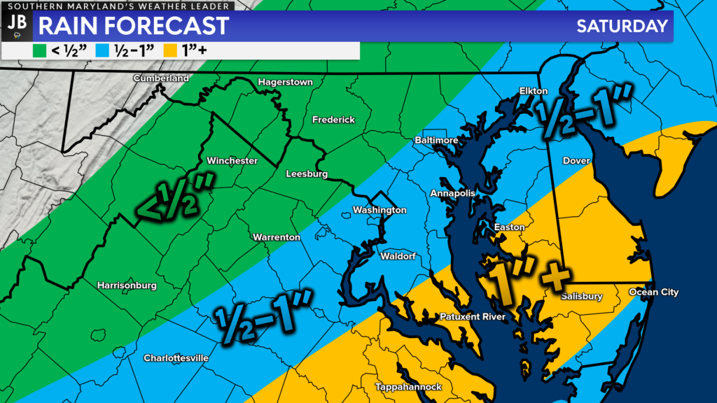
Rain Threat: The heaviest rains from this system still look likely to fall to the southeast of DC. Southern MD and Tidewater VA could see up to an inch or more of rain before lunchtime on Saturday. This is where an area of heavy rain, with 1 or 2 embedded thunderstorms, is the most likely to move through.
Suppose the system tracks far enough to the northwest. In that case, we could see several embedded thunderstorms develop within the area of heavy rain. If this happens, then we could see locally higher amounts of rain. Widespread flooding does not appear to be a big threat with this system, but localized ponding is certainly possible!
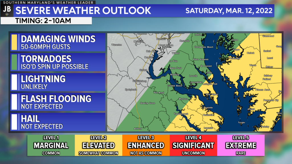
Severe Threat: As mentioned, there is a threat of seeing embedded severe thunderstorms with the morning round of heavy rain. The highest severe weather risks will be found the further southeast you head. This is because the best atmospheric dynamics for severe weather will be found to the southeast of the main system’s track. With that said, any northwest tick with the system will bring that severe weather threat further northwest as well.
Southern Calvert and southern St. Mary’s Counties have been placed under a Level 2 “Elevated Risk” of severe weather, with the remainder of the region being placed under a Level 1 “Marginal Risk.” The timeframe for potential severe weather looks to be between 2-10am Saturday morning. The severe threat should drop off quickly as cold air moves in by late-morning.
The main threat with any possible thunderstorms would be damaging wind gusts up to 60mph. This thunderstorm wind threat would be separate from the overall wind threat with this system, as these would be directly related to the storms.
There is also a non-zero tornado threat at play. While the greatest tornado threat should be kept well to our south, across the Carolinas, I cannot rule out an isolated spin-up or waterspout tomorrow morning. This would be thanks to the increased wind energy and shear throughout the atmosphere. With that said, I am not expecting a widespread tornado outbreak tomorrow morning.
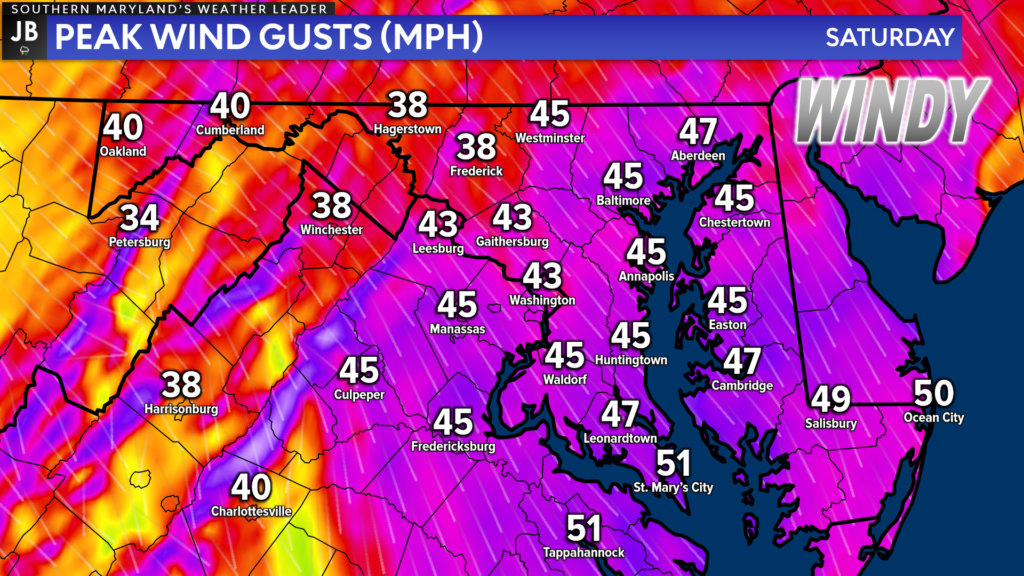
Wind Threat: To me, the biggest threat tomorrow will be the high winds after the cold front passes through. As the cold front moves through tomorrow morning, we will see winds switch direction, and come out of the northwest. There will be a tight gradient between pressure systems tomorrow afternoon, heightening the wind threat.
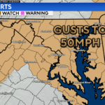
Winds are likely to gust upwards of 40-50mph at times Saturday afternoon and evening. These winds could lead to snapped branches and some power outages. These winds will also help filter down some bitterly cold air, which will lead to a dramatic drop in our temperatures, and in turn, could transition the rain over to snow.
I would expect High Wind alerts to be issued at some point today due to this high threat.
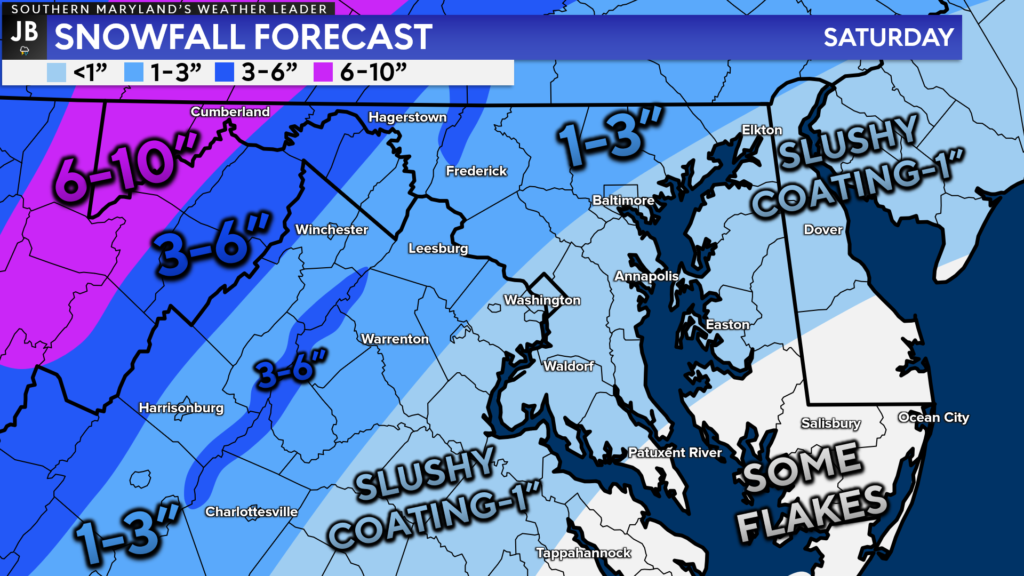
Snow Threat: Believe it or not, there is also a snow threat at play with this system. As those stark northwest winds usher in cold air, we are likely to see temperatures drop enough to gradually transition the rain to snow. This transition will occur from northwest to southeast through the morning and afternoon.
The highest snow totals will be found across the Appalachians and highlands, where this is likely to be an all snow event. Totals will tapper off the further southeast you head, as the period of time with snow decreases. With that said, it does look likely that most everyone should see at least some snow fall at some point on Saturday.
Accumulation may be hard to come by once you head southeast of DC. Our recent string of warm temperatures, the morning round of heavy rain, and high sun angle (even though the sun won’t be shinning) will all make accumulation very difficult, especially on roadways. With that said, if the snow falls fast enough, or the cold air rushes in quick enough, then some accumulation could be possible.
Over the last 24 hours, our computer guidance has trended towards a snowier solution. With that said, I am very skeptical of seeing accumulating snow in these sorts of setups, for all of the reasons I listed above. With that said, I cannot completely ignore the guidance and the powerful dynamics at play. Right now, I favor Southern MD potentially seeing a slushy coating, potentially up to an inch, of snow on grassy surfaces.
I do not think that snow will be the primary threat with this system for our region. I am much more concerned about the wind and heavy rain. However, do not discount this winter weather threat at all. While accumulation on roads will be tough, the sleet and moderate to heavy snow that will fall could make travel difficult, and temporarily bring down visibilities.
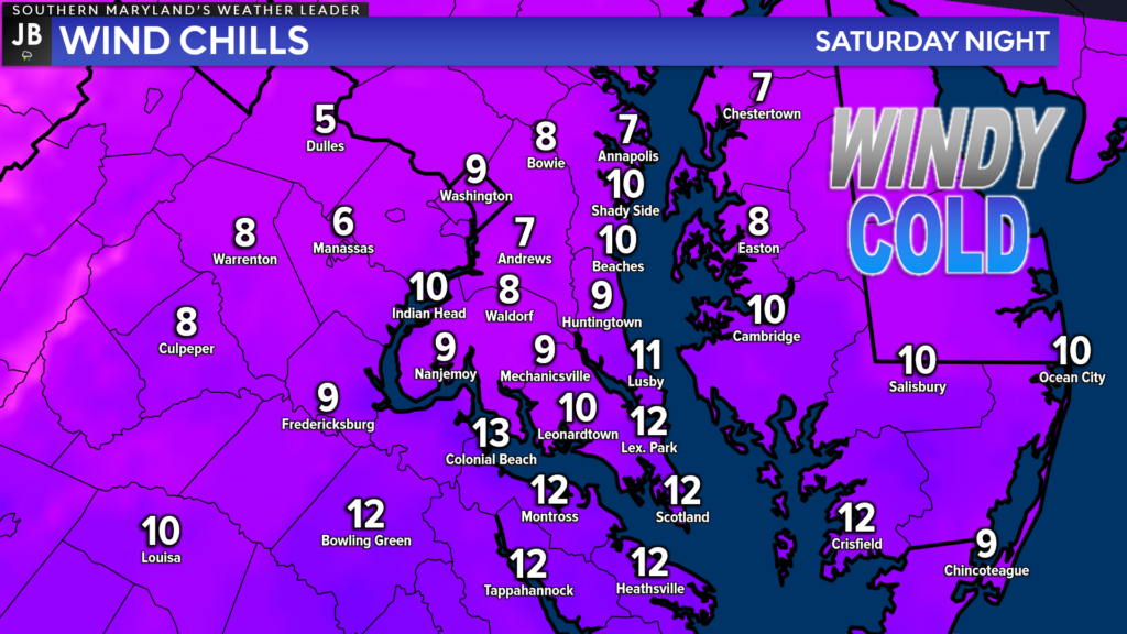
Dramatic Temperature Drop: Last but certainly not least, we will see a dramatic drop in our temperatures. Our high-temperature tomorrow will likely be recorded before sunrise! Temperatures will fall throughout the day as cold air moves in on the heels of those northwest winds. Temperatures are likely to fall from the 50s/40s in the morning to the 20s by Saturday evening.
We are likely to see our winds continue to gust upwards of 30-35mph after sunset on Saturday, and into Sunday morning. This will bring our Wind Chill values into the single digits and lower teens by the time you wake up on Sunday! This dangerously cold air will be quite the shock to our systems after the string of Spring-like warmth the last few weeks.
Temperatures are likely to drop below freezing by, or just slightly after, lunchtime on Saturday. While snowfall accumulation is not likely on roadways in our region, we are likely to see any wet spots on area roads freeze right up! This means that both the morning rain and any melted snow could turn to widespread slick spots Saturday night and Sunday morning! This will make travel quite difficult!
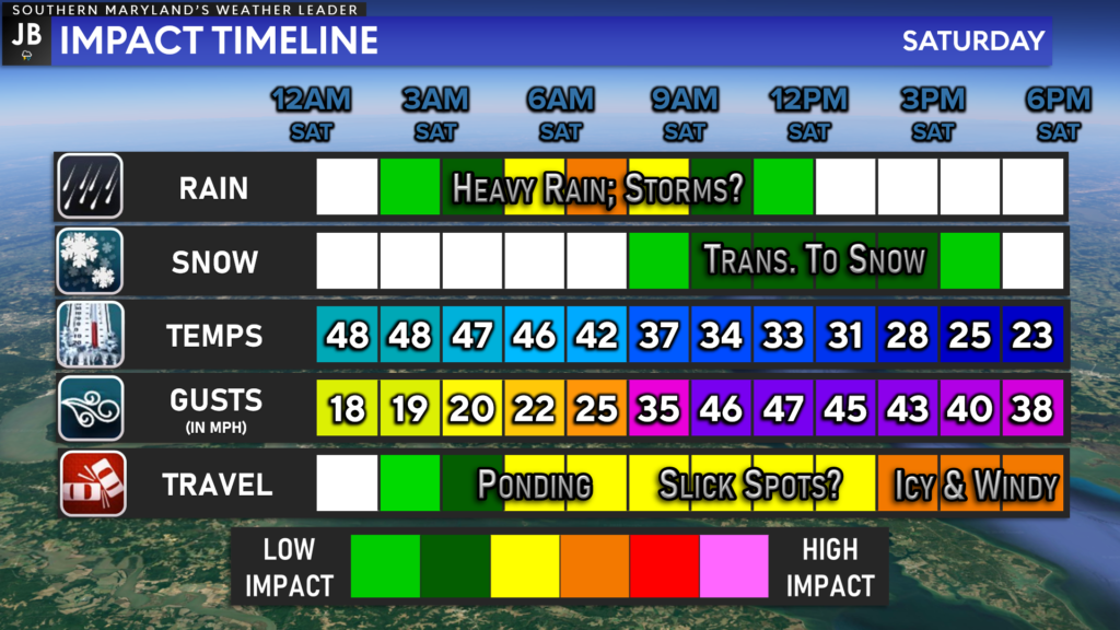
All-in-all: We are in store for quite the weather roller coaster over the next 24-36 hours! We are likely to go from sunny skies with temps in the 60s today, to potential storms Saturday morning, to potential snow by Saturday afternoon! As a result, a wide variety of weather impacts are likely tomorrow.
To me, the biggest threats tomorrow would come from the high winds that will set in tomorrow afternoon, and the heavy rain with embedded thunderstorms that will move through Saturday morning. Cold air will rush in by lunchtime, which could transition us over to a period of snow that could accumulate up to a slushy inch on grassy surfaces.
Tomorrow will be a good day to stay inside and avoid travel if possible. The combination of rain, wind, and snow could cause hazardous travel conditions and could even lead to some power outages.
Stay with JB Weather for the latest information on Southern Maryland weather. I will be with you all throughout the night and throughout tomorrow to cover this impactful system. You can always access my forecasts and updates here on the website, on Facebook, on Twitter, on Instagram, and on YouTube.
-JB

Cedar Point has been providing trusted banking, lending and personal finance solutions to the Southern Maryland Community since 1945. Visit the credit union at any of its 6 locations in St. Mary’s, Charles and Calvert counties or online at www.cpfcu.com.
1 thought on “System to Bring High Impacts on Saturday”
Comments are closed.
[…] [ March 11, 2022 ] System to Bring High Impacts on Saturday Severe Weather […]