Brought to you by Cedar Point Federal Credit Union
We have quite the active weather day on tap for the Mid-Atlantic. After a winter-like start to the week, we have seen things quickly flip to Spring! Temperatures are already off to a warm start this morning, and southerly winds will help to warm our temperatures even more! This will look to potentially set the stage for severe storms this afternoon and evening.
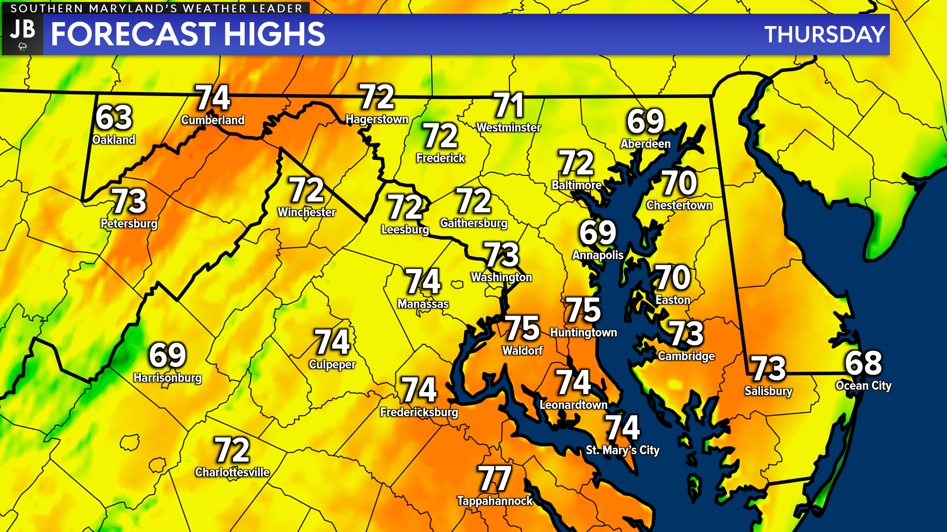
First, we will touch on the warm temperatures. Yesterday we saw a warm front move through the region, which allowed warm air to surge northward. This has allowed temperatures to remain mild overnight, with many of us starting off with temperatures in the 60s. Temperatures will continue to rise today, likely topping off in the lower-to-middle 70s for most!
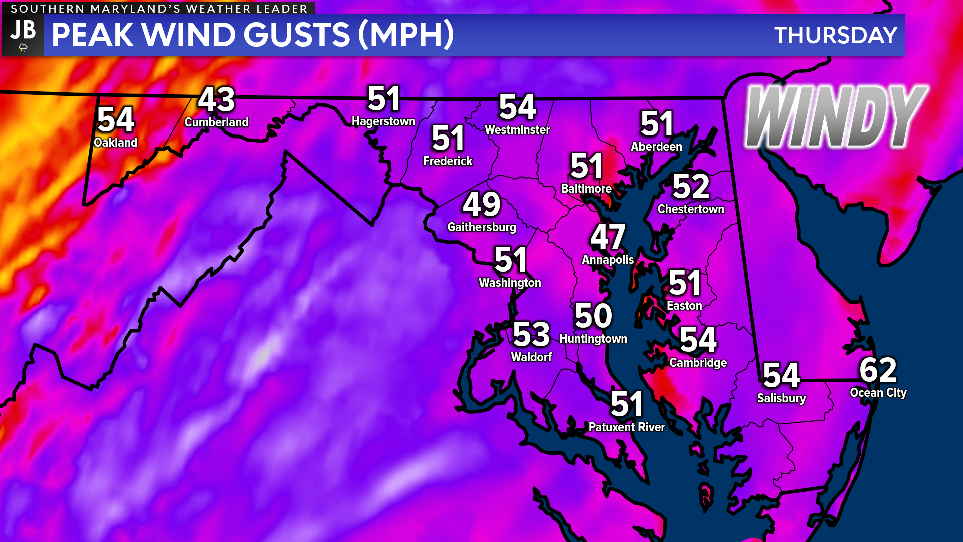
A strong southerly wind flow will be what is responsible for the warmer temperatures. Throughout the day today, regardless of storm development, we are likely to see strong winds. We could see winds gust upwards of 40-55mph at times across the state. The worst of the winds will look to impact our region from late-morning through the evening. This could lead to some scattered power outages and travel impacts for our airports and on our bridges.
Our Chesapeake’s Bounty Futurecast is doing a great job of depicting today’s rain and storm threat. Scattered showers will be possible throughout the morning, with some midday clearing. If we see skies clear enough around lunchtime, then we could see even warmer temperatures, which would add some extra storm energy to the atmosphere.
Nevertheless, we are likely to see moisture lift northward as we enter the afternoon. This should allow for some initial scattered storm cells to develop out ahead of the main cold front between 12-5pm. These cells could be severe and may try to focus on areas southeast of I-95.
Then, we will see a line of storms develop along the cold front, and push through after sunset. Within this line, there are likely to be a couple of severe storms.
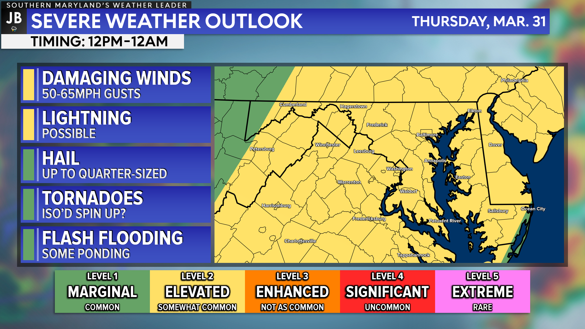
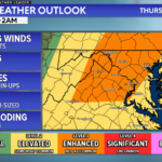
The Storm Prediction Center has placed much of our region under a Level 2 “Elevated Risk” of potentially seeing severe weather. As mentioned above, our severe weather risk will look to come in two waves– the first between 12-5pm in the form of individual storm cells and the second between 7pm-2am in the form of a line of embedded storms.
The first potential wave of storms could produce enhanced damaging winds, some small hail, and could even lead to a quick-spinup tornado. I am not expecting a tornado outbreak, though. If we fail to see enough warming this afternoon, thus limiting the amount of storm energy in the atmosphere, then this round may not be as impactful.
The second potential round of storms is what is the most likely to impact the region. We will likely see a line of storms that develops along the cold front that pushes eastward this evening. The main threat with this potential line will be enhanced damaging winds up to 60mph and localized ponding on roadways.
Our weather today is not expected to be nearly as devastating as what the Deep South saw yesterday. While we will have a lot of wind energy present for storms to tap into, we will likely lack enough storm energy that would allow for multiple severe storms to develop. If this were June or July, then this likely would be much worse for our area. However, do not let your guard down. Stay aware this afternoon and evening of changing weather conditions.
Keep in mind that severe weather forecasting is far from a guarantee of anything. The goal of these forecasts is to alert you to the potential of storms, not a promise of storms.
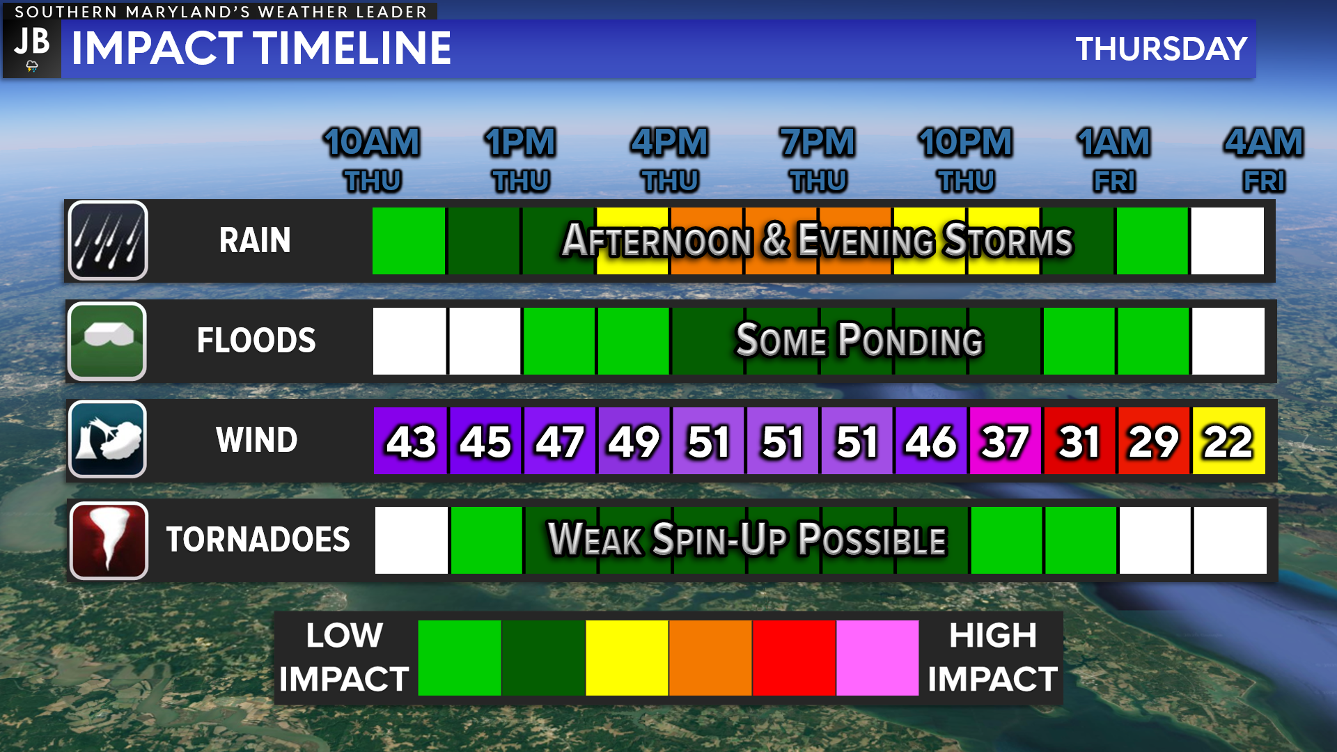
This impact timeline graphic is one that many people seem to like! This really does give you a brief snapshot of what to expect from this event. I think the big story today will be the strong southerly winds that we see throughout the day. Storms will be possible throughout the afternoon and evening, but a lack of meaningful storm energy may put a cap on how numerous potential severe storms are.
It will be important to stay with JB Weather for the latest information. I will be in the weather center all day tracking the latest developments on today’s active weather. You can always access my forecasts and updates here on the website, on Facebook, on Twitter, on Instagram, and on YouTube. JB Weather is Southern Maryland’s Weather Leader, and I am working around the clock to keep you ahead of the storm!
-JB
Cedar Point has been providing trusted banking, lending and personal finance solutions to the Southern Maryland Community since 1945. Visit the credit union at any of its 6 locations in St. Mary’s, Charles and Calvert counties or online at www.cpfcu.com.
John Bordash
View More PostsJB Weather forecaster John Bordash is working around the clock to provide Southern Maryland, and neighboring communities, with accurate and reliable weather information.