Brought to you by All in One Tag & Title
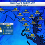
Our week-long warm-up continues today, as temperatures look to get into the 40s this afternoon. Winds from the northeast will mean that eastward-facing locations, such as our Bayside communities, will be a touch cooler today, with inland locations being the warmest.
After a chilly start this morning, we will see temperatures gradually climb throughout the day. Some spots may look to get near our seasonal average this afternoon; granted, I think only a few communities end up getting that warm. Nevertheless, the low 40s will feel nice after this latest round of cold weather!
As our eyes turn towards the long-term forecast, there continues to be a decent amount of talk about the potential for snow/ice on Friday. The weather set up by late weather will turn rather complicated as a parade of systems will look to ride along a slow-moving frontal boundary. The first moves through on Thursday with rain, and the second arrives on Friday.
These systems will bring a healthy slug of moisture northward, with bitterly cold air sitting to the northwest of the storm track. The questions we are trying to resolve with this set-up and our local forecast are:
- How far to the south and east will the eventual storm track being?
- How quick can cold air sink southward on Friday?
The answers to these questions are related. A further southeast track would allow cold air to move in quicker and could change any rain over to ice and snow by Friday afternoon evening. There are still a lot of questions with this setup, and we are not likely to have concrete answers for a couple of days. I will likely have more on this potential setup later today, so be on the lookout for that!
Stay with JB Weather for the latest information on Southern Maryland weather. You can always access my forecasts and updates here on the website, on Facebook, on Twitter, and on YouTube.
-JB

At All In One Tag & Title, we make quick work of MVA Tag & Title Services! We are located in Owings, MD on the corner of Chaneyville Rd. Give us a call at 301-327-5081 or stop by, no appointment needed! Mention you saw us on JB Weather and get $5.00 off tag & title services. Check out www.allinonellc.net today!
John Bordash
View More PostsJB Weather forecaster John Bordash is working around the clock to provide Southern Maryland, and neighboring communities, with accurate and reliable weather information.