Brought to you by Bill Oosterink, Realtor
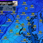
Cold air continues to rush into the region today after this morning’s cold front brought snow to northwestern areas. Looking ahead to Sunday, a weak coastal system developing over the Southeast will track northward and pass just close enough to bring light, occasional precipitation to the Mid-Atlantic and Northeast. This will not be a major storm, but it will unfold in two distinct windows depending on your location.
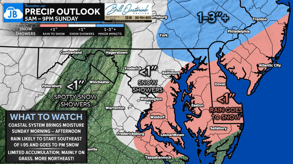
Part 1: Sunday Morning (3–9 AM) — Areas northwest of I-95 will see snow showers during the morning hours, with up to around an inch of accumulation possible in spots.
Part 2: Sunday Afternoon & Evening (3–9 PM) — Areas southeast of I-95 that are likely to start as rain will transition to snow later in the day. Up to an inch possible, mainly on grassy surfaces.
The best chance for more meaningful snowfall remains northeast of Baltimore into southeastern Pennsylvania and the Philly metro, where 1–3″+ is possible as colder temperatures allow for steadier snow during the afternoon and evening. Roads should remain mostly wet for many, but brief slick spots can’t be ruled out where snow intensity increases.
Stay with JB Weather for the latest information on impacts here in Southern Maryland and across the Mid-Atlantic. You can always access my forecasts and updates here on the website, on Facebook, on Twitter, on Instagram, and on YouTube. JB Weather is the Mid-Atlantic’s Weather Leader, and I am working around the clock to keep you ahead of any storm!
Brought to you by Bill Oosterink, Realtor. Buying. Selling. Investing. Ready when you’re ready! Check out www.somdDreamHome.com today!
John Bordash
View More PostsJB Weather forecaster John Bordash is working around the clock to provide Southern Maryland, and neighboring communities, with accurate and reliable weather information.