Brought to you by Berkshire Hathaway HomeServices PenFed Realty
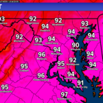
Much like the last couple of days, we will remain hot and humid as temperatures look to max out in the lower 90s. This is because the Bermuda high will still have some influence today as it continues to push hot and humid northward. This will come to an end today, though, as a cold front looks to move through this evening.
Today’s heat and humidity will lead to a decent amount of thunderstorm energy. The incoming cold front will look to be the trigger for the potential for showers and thunderstorms across the region, and tap into that storm energy. Thunderstorm development is likely to develop around the initial push of cooler air around mid-afternoon (1-3pm) before moving east towards the I-95 corridor late this afternoon (3-6pm). Another round of thunderstorms will likely impact the area late this afternoon through this evening ahead
the main cold front.
Storm motion should be fast enough to keep any flood threat localized but non-zero because there may be a couple of rounds of heavier rain associated with thunderstorms. Storms should exit southern MD around midnight, and the cold front will drop to our south overnight. Much cooler conditions
are expected behind the front. We will see low temperatures overnight fall into the 50s to lower 60s.
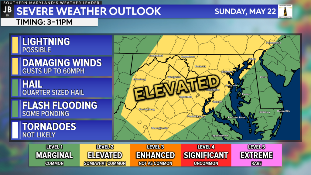
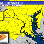
With the risk of thunderstorms this afternoon and evening, the Storm Prediction Center has upgraded much of the region to a Level 2 “Elevated Risk” of seeing severe weather. While we will lack a few key atmospheric parameters to support widespread severe weather, we will have a decent amount of storm energy present to support at least some severe weather development. As a result, we could see a couple of thunderstorms become strong to severe as rounds of thunderstorms push through.
The primary risks with any storms that develop would be localized downpours, thunder/lightning, and gusty winds up to 60mph. Hail and flooding are also threats as well today but are likely to be limited. Thanks to a lack of twisting and turning of the winds throughout the atmosphere, the tornado threat is close to zero.
It will be important to stay weather aware and to be prepared for weather conditions that could change quickly! Stay with JB Weather for the latest information on Southern Maryland weather. You can always access my forecasts and updates here on the website, on Facebook, on Twitter, on Instagram, and on YouTube.
-JB

Real Estate now! Not sure where to start? View our Southern Maryland inventory of homes, land, farms and commercial properties on penfedrealty.com. Engage with our planning tools to determine your next real estate lifestyle decision, choose your realtor as a trusted advisor. Experience the difference with service and support from real estate’s forever brand!
John Bordash
View More PostsJB Weather forecaster John Bordash is working around the clock to provide Southern Maryland, and neighboring communities, with accurate and reliable weather information.