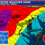
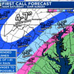
Things have begun to come into focus today, and not much has changed with my thinking. Areas along and west of I-95 will likely be cold enough for some wintry weather Saturday afternoon. Areas along and east of I-81 have enough cold air for meaningful accumulation.
Yes, this does look like a cold rain for many areas. Even the Wintry Mix zones will likely see any snow go to sleet and eventually rain–it will just take longer in the purple. We still do not have enough data to pinpoint specific amounts of anything.
However, I have given a general idea of where I lean in regards with #snow amounts. While this will be the most snow for some areas in 2 years… that’s not saying much. To me, this does not look like a “big snow” for inland areas… just a moderate one. But things will evolve.
Regardless of where you are on the map, ugly weather is likely Saturday afternoon and evening.–either cold rain, sleet, or wet snow. More information will continue to come in over the next day or so to help create a more concrete and detailed forecast.

