Brought to you by Chesapeake Orthodontics
The overnight trends with Wednesday’s system have not been good for Southern MD snow lovers. As we had discussed yesterday, this was going to be a weak and moisture-starved system. Overnight, much of our modeling showed that dry air will be an increasing issue in our region, which will limit the amount of moisture that we see.
Areas north and west of I-95 would be cold enough to see mostly snow, but the storm will struggle to get much precip up north that far. While a few flurries are possible in that region, I am expecting very little accumulation.
South and east of I-95, we will have a touch more moisture to work with, but still not much. Our marginal temperatures will likely lead to a rain/snow mix. I highly doubt that anyone in the pink region sees anything more than a coating of snow– and even that will be limited to only a few spots. Some areas in the pink zone may struggle to see any flakes at all.
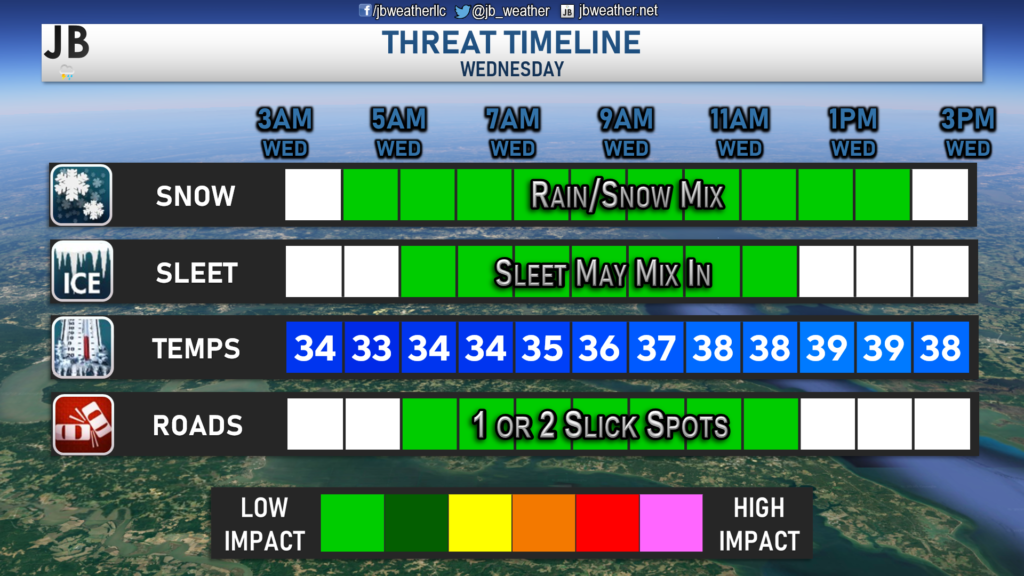
Our Chesapeake Bounty’s Futurecast does a great job of highlighting this potential. We may see some light precip move in during the pre-dawn hours of Wednesday, between 3-5am. Since the storm has been stunted southward, little precip will fall north and west of I-95. Our model shows that while snow may try to mix in at times across Southern MD, our marginal temperatures will complicate any snowfall. As I mentioned yesterday, dry air tends to be an issue with these types of weak systems. Sure enough, we are seeing that manifest now. Any precip we have will likely be out of here around lunchtime, or during the early afternoon hours.
Storm FAQs
How confident are you in your forecast? I feel decently confident that we’ll have at least some sloppy mix of precipitation on Wednesday. The remaining question is whether temperatures will be cold enough for snow, or just a few flakes with the rain. Our modeling suggests that the answer will likely be the latter of the two, which does not surprise me in this type of a setup.
How much snow will I get at my house? Check out the accumulation map. Generally, I’m expecting less than an inch of snow north of DC and potentially only a few flakes to a coating SE of I-95 where temperatures will be marginal for snow.
Could the storm bring more snow than expected? Yes. In order for this to happen, we will need heavy precipitation to develop. That will help to cool the air and high snowfall rates might overcome the effect of the warm ground. I would say that there’s a 1 in 10 chance of 1″+ in a few spots. This does not look like a big event at all, so the high-end ceiling for this event is rather low.
Could it fizzle out and leave us wet? Yes. A significant impediment for snow accumulation is the relatively warm air (temperatures above freezing) that will be in place when the precipitation first arrives. It will take some time for the precipitation to cool the air and for precipitation to change from rain to a rain/snow mix or even to just snow. It is likely that some spots may see no snow at all because of this.
Could we see nothing at all? Yes! It is also very possible that dry air overtakes the system, and leads to very little falling. This has happened in the past when weak systems try to overspread moisture across the region. I would place the chance of this happening at 1 in 4.
Will we see any of the dreaded wintry mix? There may be a period of a rain/snow mix and even some sleet as precipitation transitions to snow, but no ice will accumulate given warm ground temperatures.
When will this storm start? Early Wednesday morning between 3 and 6 a.m. in most spots.
When will the heaviest fall? Most likely during the mid-afternoon hours, but we’re likely not talking about heavy snow.
Will the snow stick? It’s not likely in Southern MD. Colder locations to the north and west could see the snow sticking on the grass and on some backroads, thanks to cooler temperatures. In the milder locations south and east of I-95, sticking will likely not happen. If it does happen, it would only be on cooler surfaces such as the top of your car and on your deck.
What will conditions be like after the storm? We will be left with clouds for much of Wednesday, after the system moves out. Temperatures will only max out in the upper 30s during the afternoon. Temperatures go back down below freezing after sunset, which could cause 1 or 2 slick spots to form. However, a mass refreeze is not likely.
Summary

All in all, this does not look to be a big event on Wednesday. We have a weak system sliding to our south that will be moisture-starved. Temperatures will be cool, but will still be marginal for snow. Along I-95 and to the south and east, we are likely only talking about a rain/snow mix at most. Accumulation and impacts are not likely across Southern MD for Wednesday. The potential is there for the dry air to completely take over, and lead to very little falling. This should not be surprising news though as early-season events rarely produce big snow.
Stay with JB Weather for the latest information on impacts here in Southern Maryland. You can always access my forecasts and updates here on the website, on Facebook, on Twitter, and on YouTube. JB Weather is Southern Maryland’s Weather Leader, and I am working around the clock to keep you ahead of any storm!
-JB

Dr. Thomas Hao and Dr. Dylan Schneider offer comprehensive orthodontic services for all ages. Schedule your free consultation today. Visit www.SOMDBraces.com today for more information!

