Brought to you by R.E. Graves Heating & Air Conditioning
There has been a ton of chatter over the last several days about an epic “50-year snowstorm” that could move into the region this weekend and drop feet of snow on Southern Maryland. I have received hundreds of messages and comments about this potential. I almost always avoid really talking about a storm more than 5-days in advance and hardly issue snowfall forecasts more than 48 hours in advance. While we are still several days before we would see any impacts, I do feel called to put out my initial thoughts on this potential threat. What I will say is that snow-lovers should hold their excitement… alright, let’s get into my “Way too Early” outlook!
Setup
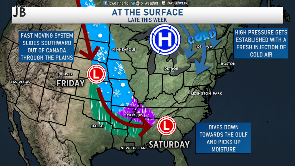
Late this week, we will have a fast-moving storm system develop in southwestern Canada and follow the Jetstream due southward. This will spread snow across much of the Northern Plains on Friday before it arrives to the southern US on Saturday, to pick up moisture. At the same time, a new area of high pressure will be getting developed in southern Canada which will deliver a fresh injection of cold air for much of the Eastern US. All of this seems pretty certain to happen. The questions and speculation begin to come after this point with what could happen.
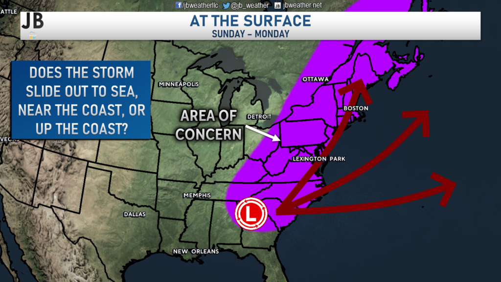
Once our system reaches the southern US, we could see the storm either slide out to sea, near the coast, or up the coast. The ultimate path that this storm ends up taking will come down to a few things:
- How strong is this storm when it reaches the southern US on Saturday?
- How fast does a seperate ocean storm well of the East Coast move out of the picture late this week?
- How strong is the high pressure over southern Canada?
- What is the “tilt”, or orentation, of this storm?
- Is it able to interact with “northern stream” energy in the northern US?
The answers to all of these questions will determine the ultimate fate of this system, where it goes, and how it impacts our local region. The graphic below is a simplified version of the different scenarios that could play out.
Scenarios
The evolution of this storm will vary a lot depending on the answers to the five questions I asked above. We will likely not have a good handle on any of these answers for a few more days– likely Thursday at the earliest. With that said, these are the three preliminary solutions I see potentially playing out.
Out to Sea
Overview: This would be the least impactful solution. The ocean storm I briefly mentioned would be slow to move into the Canadian Maritimes and would leave the storm track rather flat, instead of buckling along the coast. As a result, the storm harmlessly slides out to sea off the Southeast coastline.
Locally: This would likely lead to nothing more than just a few flurries on Sunday. Locally, no accumulation would be expected. Some minor accumulations could be found in the Carolina foothills.
Probability: 20% Chance. This looks like the least likely chance at the moment, but cannot be ruled out. This is what much of the guidance showed earlier this week; except the one run of the GFS that went viral.
Near the Coast
Overview: This would be the best-case scenario for Mid-Atlantic snow lovers. The ocean storm would move into the Canadian Maritimes at a decent clip, allowing the storm track to buckle a little bit. This would allow the storm to take a gradual turn up the coastline. The storm would also be moderately strong.
Locally: This would lead to an accumulating snowfall for much of the Mid-Atlantic with enough cold air present. It would be too early to predict totals, but accumulation would be likely in our area.
Probability: 40% Chance. This scenario has a chance and was displayed on a lot, but not all, of last night’s model guidance.
Up the Coast
Overview: This would be the worst-case for Mid-Atlantic snow lovers. In this scenario, the ocean storm would move out in plenty of time and our storm system would be plenty strong. The resulting storm track would be very close to the coastline.
Locally: This would likely lead to a rain/snow mix that would go over to cold rain, as warmer ocean air would move into the region. Accumulations SE of I-95 would be kept down. Even the NW DC suburbs may struggle with mixing.
Probability: 40% Chance. This is the scenario that all of our guidance (including the American & European models) show. The probability of this is on the rise, but for now I will reserve placing it as the most likely.
Summary
There is a lot of uncertainty with this forecast– which makes sense. We’re still 5-6 days out from this system potentially affecting us. It will be hard to say for sure what will happen until we get more answers on this system and the atmospheric drivers around it. Snow lovers, I would calm down your excitement! There is no certainty at this point what we could see locally. All scenarios are still in play.
I will not be issuing any snow maps until we are within 48 hours of this system. Any forecasts issued before that point are highly likely to change. I would disregard any model snow maps that you may see. The viral post this weekend that showed 20-40″ snow in our region was nothing but hype to attract attention. Please, stay away from those types of posts and the people that post that type of stuff.
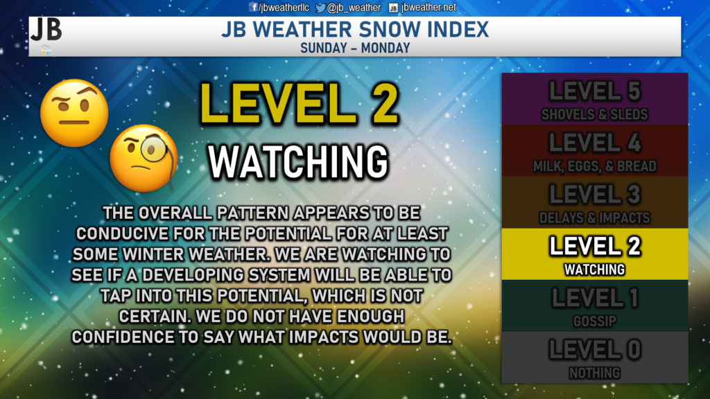
As things stand now, I will place us on a Level 2 on the Snow Index. Sure, the pattern looks favorable for a potential winter storm. However, we do not have enough information or data to say with any certainty what will happen.
Stay with JB Weather for the latest information on impacts here in Southern Maryland. You can always access my forecasts and updates here on the website, on Facebook, on Twitter, and on YouTube. JB Weather is Southern Maryland’s Weather Leader, and I am working around the clock to keep you ahead of any storm!
-JB

R.E. Graves Heating & Air Conditioning is a ⭐️⭐️⭐️⭐️⭐️ HVAC Contractor serving St Mary’s & Calvert. Just mention JB Weather to Save 20% off your next Heating repair bill when you Book now! regraveshvac.net/jbweather20off
2 thoughts on “Weekend storm? Potentially… Hold your excitement though”
Comments are closed.
Great forecast information but praying it goes out to sea
[…] [ January 11, 2022 ] Weekend storm? Potentially… Hold your excitement though Top Storie… […]