Brought to you by Chesapeake Orthodontics
The forecast for the storm threat on Saturday continues to hold low confidence. As we have been talking about over the last few days, the premiere question with this forecast is– just how far west the developing coastal storm will be allowed to come? Unfortunately, our model guidance is offering little help in resolving these questions, even as we get closer to the event. With such a wide variety of justifiable solutions being on the table, this forecast is going to require me to lean into the science and with my gut.
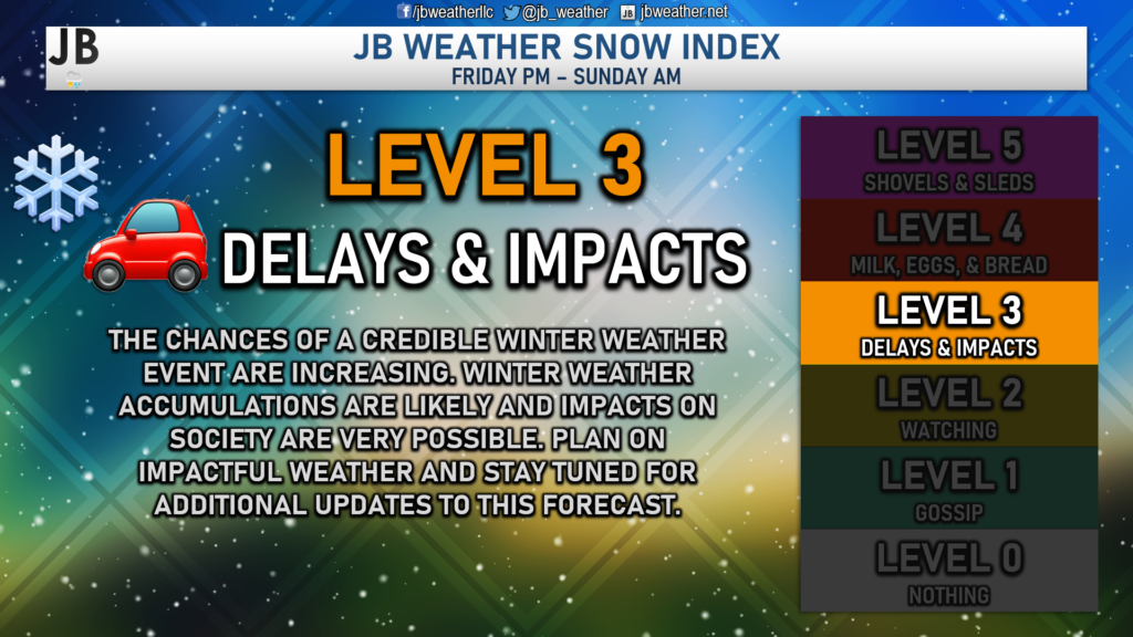
As things stand right now, I will keep the Snow Index at a Level 3. I do think that accumulating snow is likely, but we likely will not see enough to require extensive preparations. I think you can save the trip to the store to pick up milk, eggs, and bread. However, I would expect some travel delays and impacts for Saturday morning.
The Setup
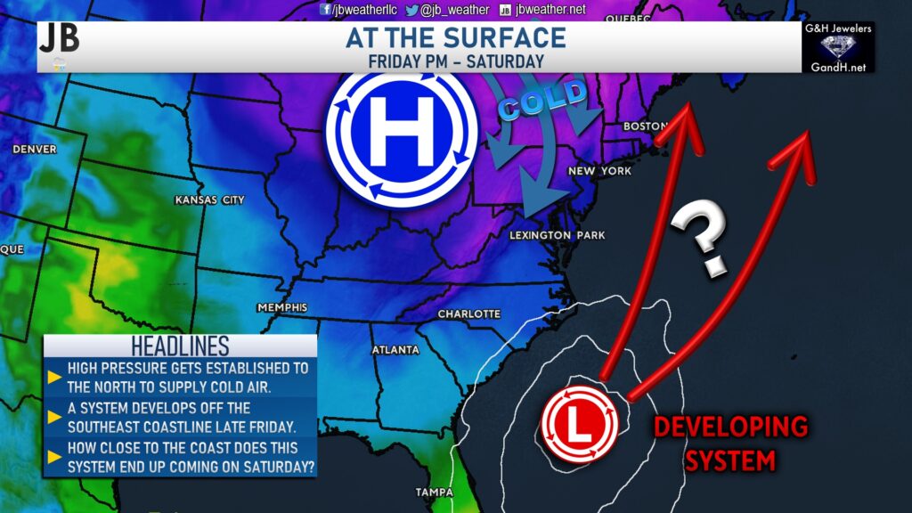
High pressure will get established north of our region by Friday, to supply a fresh injection of cold air. At the same time, we will see a system develop off the southeast coastline. This system will move northward over the weekend, with plenty of moisture. Additionally, a weak piece of atmospheric energy will be moving across the northern US, which will look to bring an initial round of snow to the Mid-Atlantic, late Friday. This initial part of the forecast seems pretty locked in. The question is, where does the storm end up tracking as it moves northward? Does it come closer to the coast or out to sea? As we did yesterday, let’s break these scenarios down a little bit more.
Scenario 1: Coastal Track
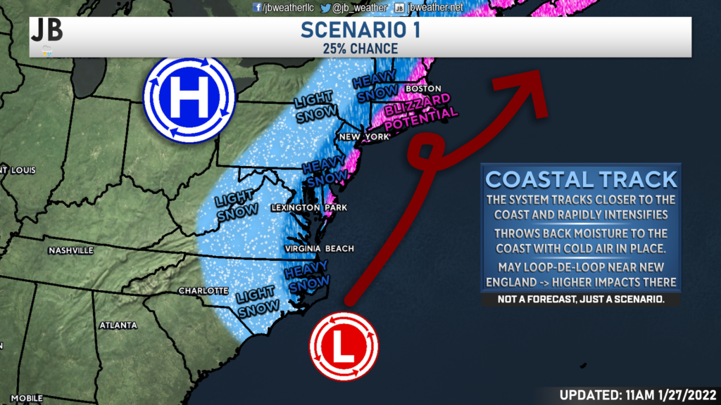
This is type of scenario would feature the developing area of low pressure to track closer to the coast. As it does so, it would likely merge with the northern atmospheric energy, which would help also slow the storm down. The end result would be heavy snow along and east of I-95, with the potential for blizzard conditions along the Atlantic coastline. Thanks to the loop-de-loop, New England would likely see prolonged blizzard conditions with this type of solution. This would also place high snow totals in Southern Maryland. This is a solution that models like the European and NAM have been trying to show. With that said, the upper atmospheric pattern to me is not super favorable for this type of setup. While I will not totally write this off yet, I would peg the chances of this solution verifying at around 25%.
Scenario 2: Eastern Track
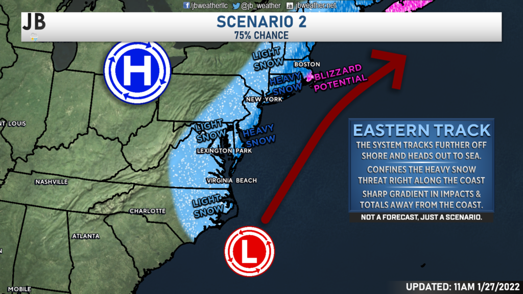
The other scenario on the table is a more eastward-based track. While the storm would still be decently strong as it moves northward, it would have little interaction with additional northern atmospheric energy. The end result is that the storm does not get pulled in as close to the coast and is allowed to slide out to sea at a decent clip. While this solution would still bring snow to many regions, it would only focus the heaviest snow right along the coast and in New England. This is the solution that our American model has been showing for a couple of days now. I think this is closer to the actual result. I give this scenario the edge against Scenario 1 and place its chances at 75%.
Timing
Our Futurecast model is shown above and simulates how the storm may unfold. I will say that our model has been more the camp of Scenario 1 than Scenario 2. That’s to say, our model favors a more westerly track, closer to the coast. As a result, this model has more snow in our region. While I think the snow output is likely overdone, I do like the general timing that it has.
We will likely see snow break out across the region Friday evening, probably around the evening rush hour, thanks to the northern energy moving through. Initially, this snow will not be too heavy. It will be light and manageable. However, as the coastal system moves up the coast and strengthens, we will see the snow pick up in intensity, especially for southern and eastern zones. Snow is likely to fall throughout the night and into Saturday morning. The heaviest snow will likely fall along the Delmarva and into New Jersey as the system pulls northward. We will see the snow wrap up from west to east by midday Saturday. The snow will hang on the longest at the coast.
Accumulation Maps
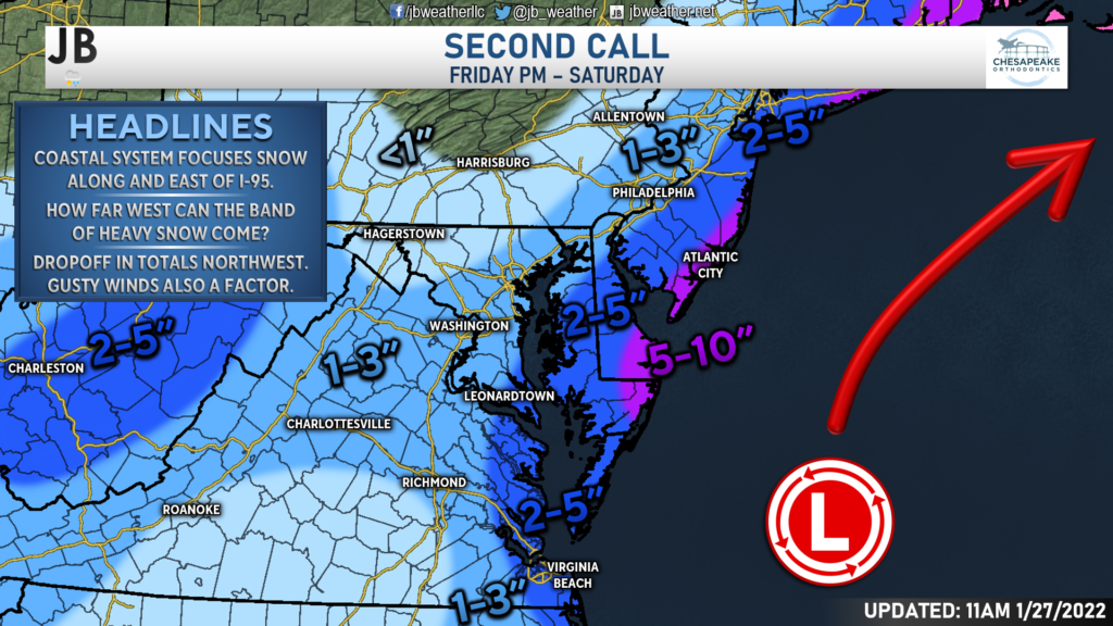
With all of that in mind, it looks very likely that the coast will see the heaviest snow, areas west of I-95 will see the lightest snow, and we will be sandwiched in between. The gradient between these two zones will be tight! Additionally, with Scenario 2 looking a little more likely, I have shifted my zones east, just a touch. While it is not a huge shift, just 25-40 miles, it does lead to be implications.
As things stand right now, I think the Delmarva could very well pick up 5-10″ of snow throughout the event. I think 2-5″ is doable along the Bay, with 1-3″ west of I-95. The snow west of I-95 is likely to fall mainly on Friday night with the northern energy, whereas the snow on the coast is likely to fall on Saturday. Southern MD is in the middle, so I would expect most of our snow to fall during the first half of Saturday.
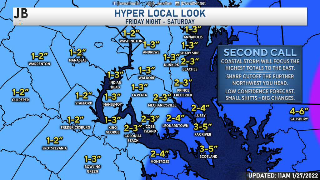
Locally, I think the highest totals will be found in far Southern St. Mary’s County. I think south of Lexington Park is the area that has the best chance to get up to 5″ of snow. This is because this is the region that will be the closest to the storm center. The further west you head, the lower the snow totals. And that drop-off may happen fast and dramatically.
Right now, I think much of central and northern St. Mary’s County, as well as Calvert County, could be on tap for a general 2-4″ of snow. I think spots south of Leonardtown and south of Prince Frederick will have the best chance to see up to 4″– but not everyone will see that much.
Zones west of Route 301 are likely to only see 2-3″, with areas west of I-95 seeing only 1-2″. The significant factor for our local forecast will be how far west the precipitation shield with the storm can come. The further west it comes, the higher the totals. Conversely, the further east it goes, the lower our totals will be.
What the Models Say
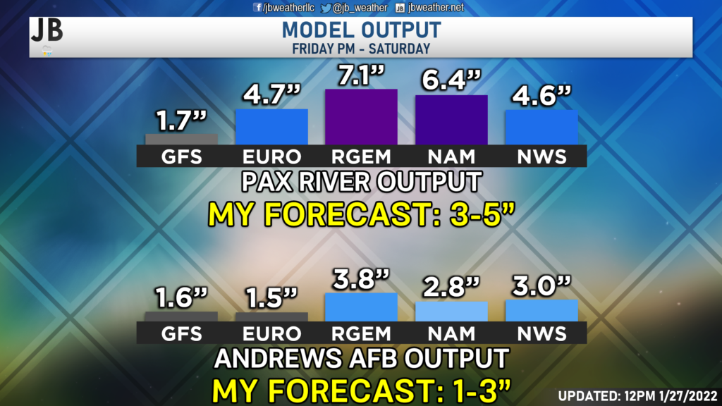
Most of our midday model data is in & here’s a general look at what each model’s snow output looks like. Many of our models have come up, and are on the upper side of my forecast. However, the GFS (which has done well this winter) remains low! Which model ends up being right? This is a classic model fight! These models are just tools in a forecasters toolbox, not a direct forecast. This just gives you a look at some of the potential scenarios that could be possible. I like using this bar graph to show the wide range of possibilities, and not just one high-end or low-end extreme.
These models are just tools in a forecasters toolbox, not a direct forecast. This just gives you a look at some of the potential scenarios that could be possible. I like using this bar graph to show the wide range of possibilities, and not just one high-end or low-end extreme.
Current Alerts
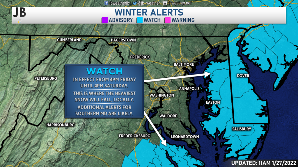
Overnight, Winter Storm Watches (shown in blue) were issued for the Northern Neck & Delmarva from Fri. PM – Saturday. This is where the heaviest snow is likely fall, locally. It looks like these watches skip right over Southern MD! I do expect additional alerts to come for Southern MD. But this shows how our region is right on the edge!
Impacts
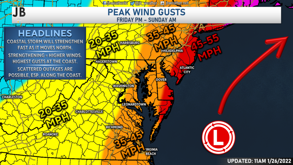
In addition to the snow, the winds will also be a factor at play with this forecast. As systems strengthen, they pull in more energy that is around them. We experience that here at the surface as increased wind. The highest wind gusts will be found along the coastline, closest to the storm system. 45-55mph gusts look possible from Ocean City northward into New England. East of I-95, we could see 35-45 wind gusts at times. These wind gusts could cause coastal flooding, especially at the Atlantic beaches, and scattered power outages.
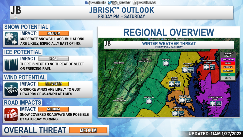
I think that this will end up being a moderately impactful storm here in Southern Maryland. We will likely see moderate snowfall accumulation in our southern and eastern zones, which will likely lead to snow-covered roadways by Saturday morning. The highest impacts will be felt on Delmarva, where snow totals are likely to be the highest, with wind gusts up to 55mph being possible.
Storm FAQs
How confident are you in your forecast? I have low-to-medium confidence in this forecast. I feel pretty certain that we will see snow Friday night into Saturday. The question is, just how far west is the axis of heavier snow able to come. The uncertainties with that question is what brings down my confidence level for this system.
Where will the heaviest snow fall? The highest totals look likely to be concentrated on Delmarva, and point north along the Atlantic coastline. The lighter snow totals will be found west of I-95, which leaves our region sandwiched in between these two zones.
When will the snow start? Current guidance shows that the snow may begin between 4-7pm on Friday.
When will the heaviest snow fall? Probably during the morning hours between roughly 12am and 7-9am on Saturday.
When will the snow end? The storm should begin to pull away from the region by midday Saturday, which will allow the snow to shut off from west to east by early-to-mid afternoon.
How much snow will I get at my house? Check out the accumulation map. Generally, I’m expecting 2-5″ south of Prince Frederick and Mechanicsville, and 1-3″ northwest of there.
Could more or less snow fall than currently forecast? Absolutely. In order for even more snow to happen, we would need to see the storm track further west, along the coast. This would allow those heavy snow bands to develop right over Southern MD. On the other hand, if the storm takes a slight jog to the east, many areas may struggle to see much. In light of these plausible scenarios, here’s my assessment of snowfall probabilities:
15% chance: <1″
30% chance: 1-3″
35% chance: 3-5″
20% chance: 5-8″+
As you can see, I think there is a greater than normal chance of either a bust (less snow than expected), with those chances taking up nearly 45% of possible outcomes. The chance of a boom (more snow than expected) is a tad elevated as well. This forecast will likely be either feast or famine.
Will the snow stick? It is likely that we see snow accumulation on both grassy surfaces and on roadways. The recent cold shots have helped to bring down ground and road temperatures. I think the snow will have no problem sticking as soon as it falls, which is what will lead to area-wide issues.
Any chance of a wintry mix of freezing rain or sleet? I am not worried about an icy mix with this storm. Temperatures look to stay at, or below, freezing throughout this event.
Summary
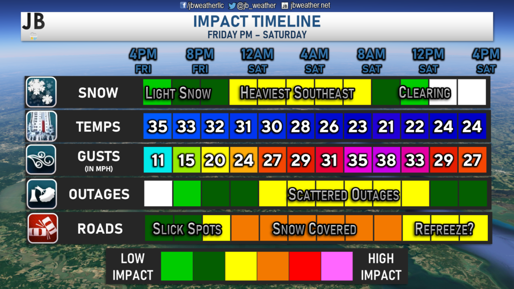
Boy, is this a difficult forecast! The exact track of the low, and a shift of 25-50 miles either west or east, will make all the difference in the forecast. It is very possible that we see very little snow, and it is also possible that we see several inches of snow. All possibilities are on the table. Right now, I would lean towards a less significant snowfall in Southern MD. With that said, southern and eastern zones will likely see the most, with some spots potentially seeing up to 4-5″. Totals will drop off quickly northwest of there. With all of that said, I do think that we are likely to see moderate impacts as we head into Saturday. Roads are likely to be snow-covered, and some scattered power outages are yet again possible thanks to gusty winds. Thankfully though, this will not likely be a heavy, wet snow. We will need to monitor how far west the system comes and how strong it gets. Both will play significant roles in determining how much snow does indeed fall and what the impacts could look like. Last-minute shifts could lead to big implications for our forecast.
It will be important to stay with JB Weather for the latest information on this winter storm and its impacts here in Southern Maryland. You can always access my forecasts and updates here on the website, on Facebook, on Twitter, and on YouTube. JB Weather is Southern Maryland’s Weather Leader, and I am working around the clock to keep you ahead of the storm!
-JB

Dr. Thomas Hao and Dr. Dylan Schneider offer comprehensive orthodontic services for all ages. Schedule your free consultation today. Visit www.SOMDBraces.com today for more information!
