Brought to you by All in One Tag & Title
This week is off to a hot and humid start, with many spots getting into the lower 90s today. This is thanks to a developing “heat dome”, or an area of high pressure that is inducing high temperatures, to our south. This will set the stage for a potential storm risk in the Mid-Atlantic on Tuesday morning.
In this article, I will break down all aspects of the forecasts, the timing, and the impacts you can expect. My apologies for how long this is (you can only imagine my patience writing all of this haha). If you are looking for a quick summary, check out the Summary section at the bottom of the article (but you will get a better understanding from reading this whole article).
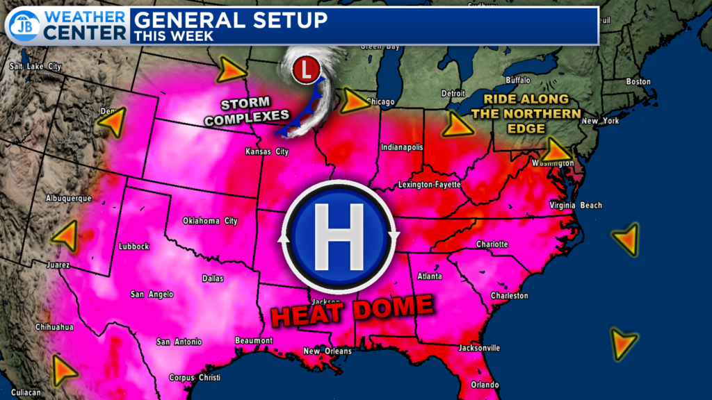
Our region sits on the northern edge of this heat dome, thankfully sparing us from the worst heat. However, as long as this heat dome is around, this increases our risk of thunderstorms. This is because the stark contrast in temperatures on either side of the “heat dome” can cause storm complexes to develop on the edges of the “dome”. The flow around these “domes” is clockwise, which would allow for potential storm complexes to move eastward from the Great Lakes into the Mid-Atlantic.
Sure enough, this is the setup that will be at hand today and tomorrow. There has been plenty of hype today about this potential storm complex, and whether we could see a “derecho” move through our region. Let’s break this down a little bit and work through the forecast.
Our Chesapeake’s Bounty Futurecast shows that we will see a storm complex develop and organize over Wisconsin and Michigan later on this evening. How far north or south we see this complex develop is important for our local forecast. Nevertheless, this complex will mature in a healthy Mesoscale Convective System, or MCS for short; which is just a complex of thunderstorms that becomes organized on a scale larger than the individual thunderstorms and normally persists for several hours or more.
Futurecast shows this MCS move southeastward, through Indiana and Ohio during the overnight hours. The MCS will bring this region a damaging wind and heavy rain threat. We will then see this system begin to approach our region tomorrow morning.
This part of the forecast becomes very uncertain, even though it is around 12 hours away (depending on the time that you’re reading this). We know that the MCS will approach the Appalachian Mountains around sunrise tomorrow morning. However, the exact placement and strength of this storm are unclear.
As I mentioned earlier, the exact development point and track through the Great Lakes are critical. If it is further north, it would then focus its attention between Fredericksburg and Philadelphia. If it is further south, it would focus its attention from Washington to Charlottesville.
Additionally, how much storm energy exists in our region tomorrow morning as this system approaches and can it survive the track over the mountains? There is a reason we do not get a lot of severe weather around here in the morning hours, and it’s because of a lack of heating. Thunderstorms feed off of heat and humidity, which is the most ample in the afternoon and evening. How much will be left across our region tomorrow morning? We will have to wait and see.
With all of that said, Futurecast tries to push this MCS through between 6am and 2pm on Tuesday. The initial push of moisture as this moves through would be accompanied by heavy rain and some gusty winds. This initial push would be where the highest severe weather risk exists. Rain then lingers behind into the early afternoon.
I see how it is possible that this solution is correct. I can also see how several other different solutions are possible as well. This could fizzle out as it crosses the mountains, track to our northeast (across the Philly area), or to our southwest (across the Charlottesville and Richmond areas). As much as people hate hearing this because they want to be able to plan, this really will be a waiting game to see what happens.
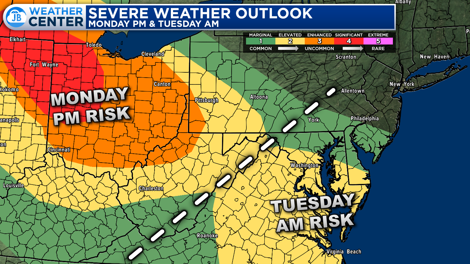
The Storm Prediction Center has been hard at work issuing their severe weather outlooks and monitoring conditions. Shown above is the combined outlook for this evening and Tuesday morning. Areas northwest of the white line have their risk for Monday evening, and areas southeast of the white line have their risk for Tuesday morning.
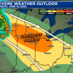
A very uncommon Significant Risk has been issued across northwest Ohio, northeast Indiana, and southern Michigan, with the Enhanced Risk expanding through much of Ohio. This is where we are the most confident that this system will move through.
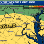
In our region, we have been placed under a Level 2 “Elevated Risk” of severe weather from this system. This lower rating for our region is largely due to the higher uncertainty in the forecast. As a result, if confidence increases that we will see impacts from this system, then we could see an upgrade late tonight to a Level 3 “Enhanced Risk.” Again, this is all a waiting game with this type of setup.
Keep in mind that severe weather forecasting is far from a guarantee of anything. The goal of these forecasts is to alert you to the potential of storms, not a promise of storms.
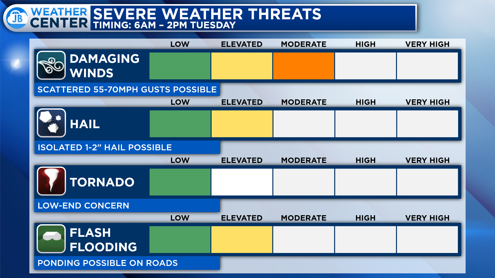
If this system does indeed move through, our highest risk locally will come from damaging winds. We could see 55-70mph gusts with the initial push of moisture. There are also non-zero hail and tornado threats with this system. With that said, lines of storms like these almost always tend to have a higher wind threat than anything else. These wind gusts could cause some power outages and damage to trees.
“Derecho” is a term that has been thrown around a lot over the last 48 hours for this storm threat. For many people this makes them think right back to the June 2012 derecho that ripped through our region.
A “derecho” is a type of MCS. Derechos are a long-lived, rapidly moving line of intense thunderstorms that produces widespread damaging winds in a nearly continuous swath. By definition, the term “derecho” applies to a complex line of thunderstorms that travels a minimum distance of 240 miles or more, and produces a nearly continuous and widespread swath of damaging winds over that distance, with concentrated areas of wind speeds over 58 mph.
The June 2012 example is a very extreme case of what a derecho is and an exceptionally rare example of an MCS. Most MCSs are not nearly as strong as the June 2012 derecho. This is similar to how Hurricane Katrina is an exceptionally rare example of what a Hurricane is.
Yes, this may be a strong MCS that ends up getting classified as a “derecho.” With that said, I do not expect conditions like what we saw in June 2012.
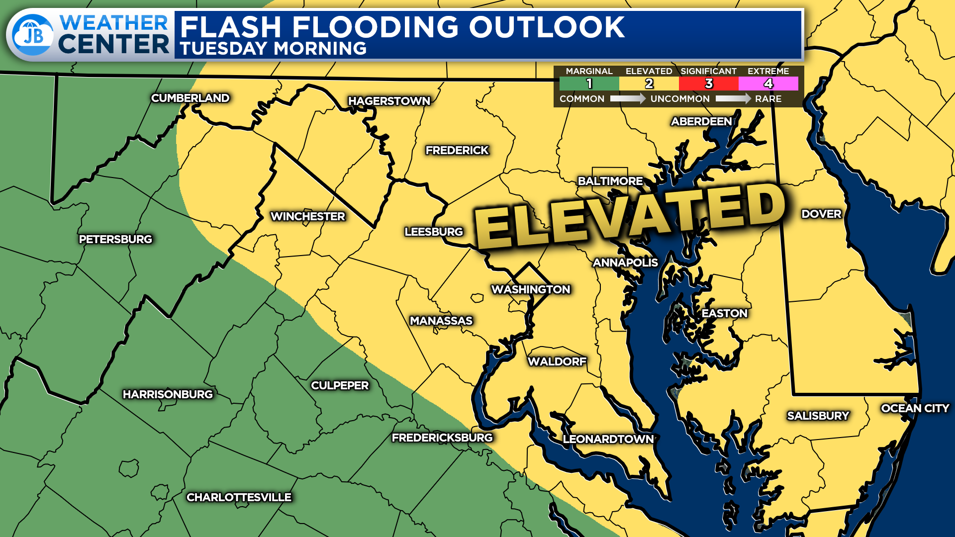
Along with the threat of severe weather, this system could also bring an elevated risk of flash flooding to the region. Our atmosphere tomorrow morning will be moisture-rich. This means that there will be a lot of water available for this system to tap into if it does move through. Some spots could see 1-2″ of rain fall tomorrow morning, causing travel issues.
The Weather Prediction Center has placed our region under a Level 2 “Elevated Risk” of flash flooding tomorrow morning. The flash flooding scale is slightly different than the severe weather risk scale, where this scale only has 4 levels and not 5. This means that a Level 2 risk is markedly more problematic. Stay aware of this threat as well.
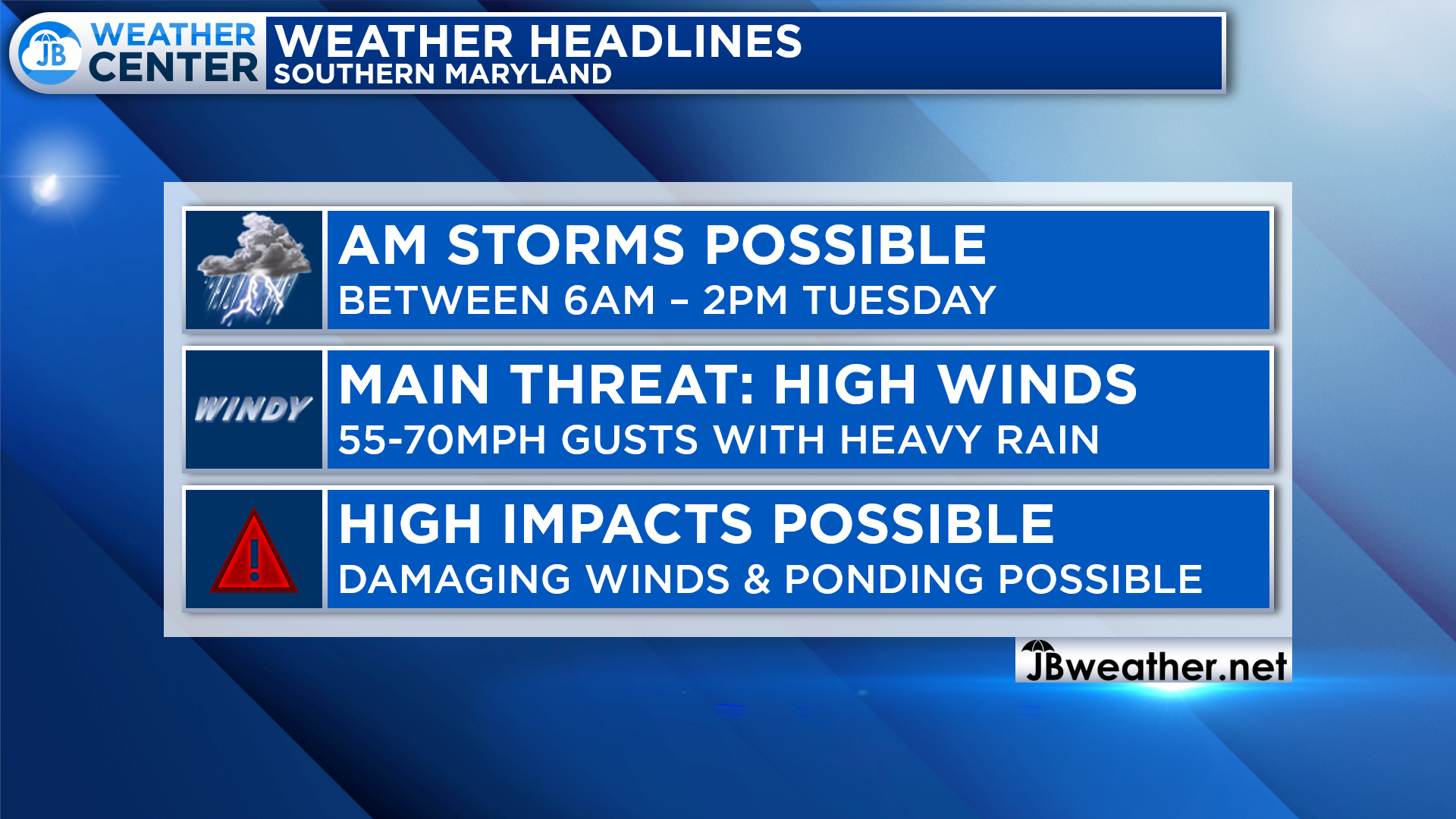
SUMMARY: Tomorrow morning could be an active one across the region as a developing thunderstorm complex develops across the Great Lakes. There are plenty of questions about this potential system, and there is high uncertainty on whether it will make it into the Mid-Atlantic tomorrow morning. If it does, we could see moderate to high impacts across the region from gusty winds and heavy rain. The time frame to watch is from 6am – 2pm on Tuesday. We are already under Elevated Risks of severe weather and flash flooding tomorrow. With that said, this storm threat is not guartunee. It is totally plausible that we are able to escape from this unscatlhed. However, we do need to be prepared and aware of what could happen.
I would dismiss any comparisons being made that this could be a repeat of the June 2012 derecho. I highly doubt that this system will be as impactful or as strong as that event. With that said, I will repeat this– gusty winds and heavy rain are definitely possible tomorrow morning. Stay weather aware tomorrow morning and be aware of weather conditions that could change quickly.
It will be important to stay with JB Weather for the latest information on this system and its potential impacts here in Southern Maryland. I will be in the storm center all night and tomorrow morning to provide coverage. You can always access my forecasts and updates here on the website, on Facebook, on Twitter, on Instagram, and on YouTube. JB Weather is Southern Maryland’s Weather Leader, and I am working around the clock to keep you ahead of any storm!
-JB

At All In One Tag & Title, we make quick work of MVA Tag & Title Services! We are located in Owings, MD on the corner of Chaneyville Rd. Give us a call at 301-327-5081 or stop by, no appointment needed! Mention you saw us on JB Weather and get $5.00 off tag & title services. Check out www.allinonellc.net today!
John Bordash
View More PostsJB Weather forecaster John Bordash is working around the clock to provide Southern Maryland, and neighboring communities, with accurate and reliable weather information.