Brought to you by R.E. Graves Heating & Air Conditioning
This morning, the details are coming into better focus for the accumulating snow that looks likely to swing through the region overnight and into tomorrow morning. After a slow start this winter, we have picked things up here in January. While this storm will not be nearly as significant or as impactful as Monday’s storm, we will still see moderate impacts across the region. For just a quick summary of the forecast, I suggest you look at the Storm FAQs and the Summary graphic at the bottom of the page!
The National Weather Service has issued a Winter Weather Advisory for our entire coverage area, which is in effect between 9PM tonight and 5AM Friday. The advisory, shaded in purple, is for a general 2-4″ of snow across the region. While the amounts will not be high, impacts will be heightened for the Friday morning commute. Winter Storm Warnings are in effect for the mountains for much higher snow totals.

I was asked this morning on Twitter if I think that Southern Maryland could be upgraded to a Winter Storm Warning. The snowfall criteria for a Winter Storm Warning in Southern Maryland is at least 5″ over more than 50% of a county. While it is not beyond the realm of possibilities that a couple of communities could see that much, I don’t think it happens on a wide enough scale to warrant warnings. I think the Winter Weather Advisory is just fine, as things stand right now.
Timing
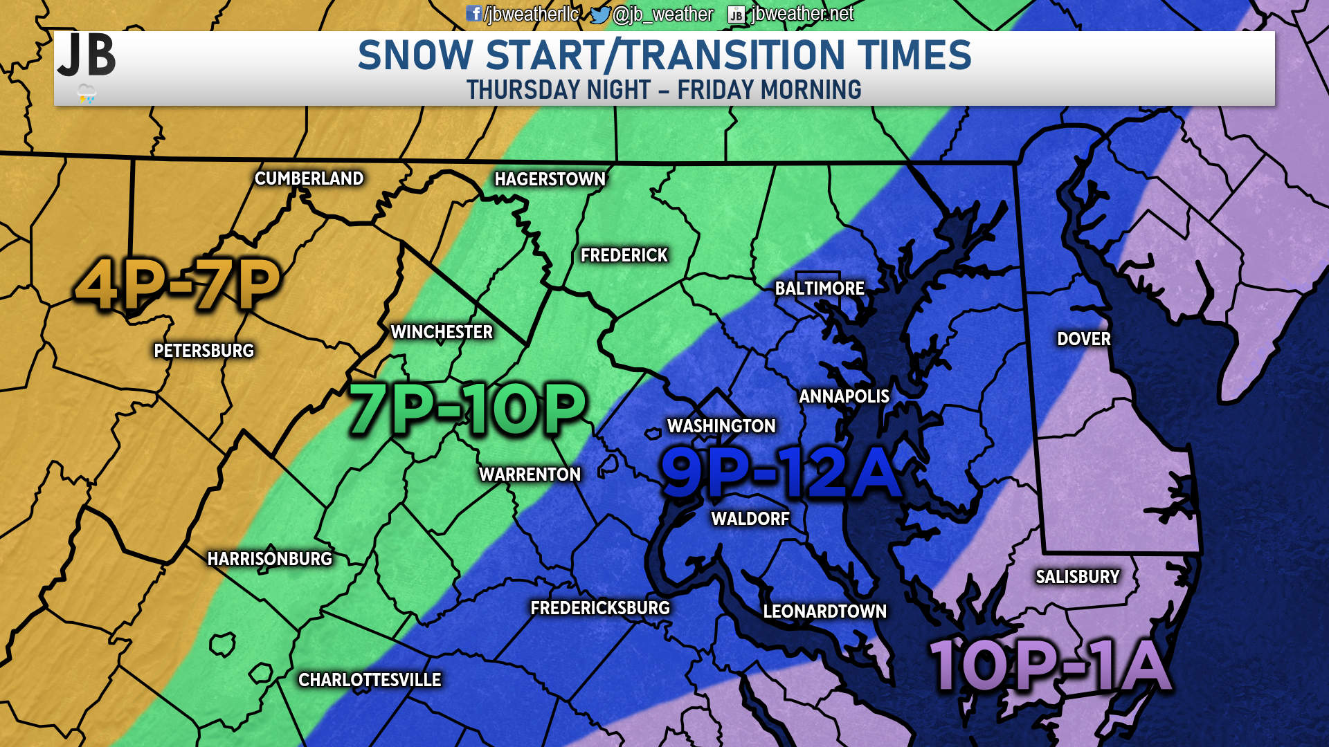
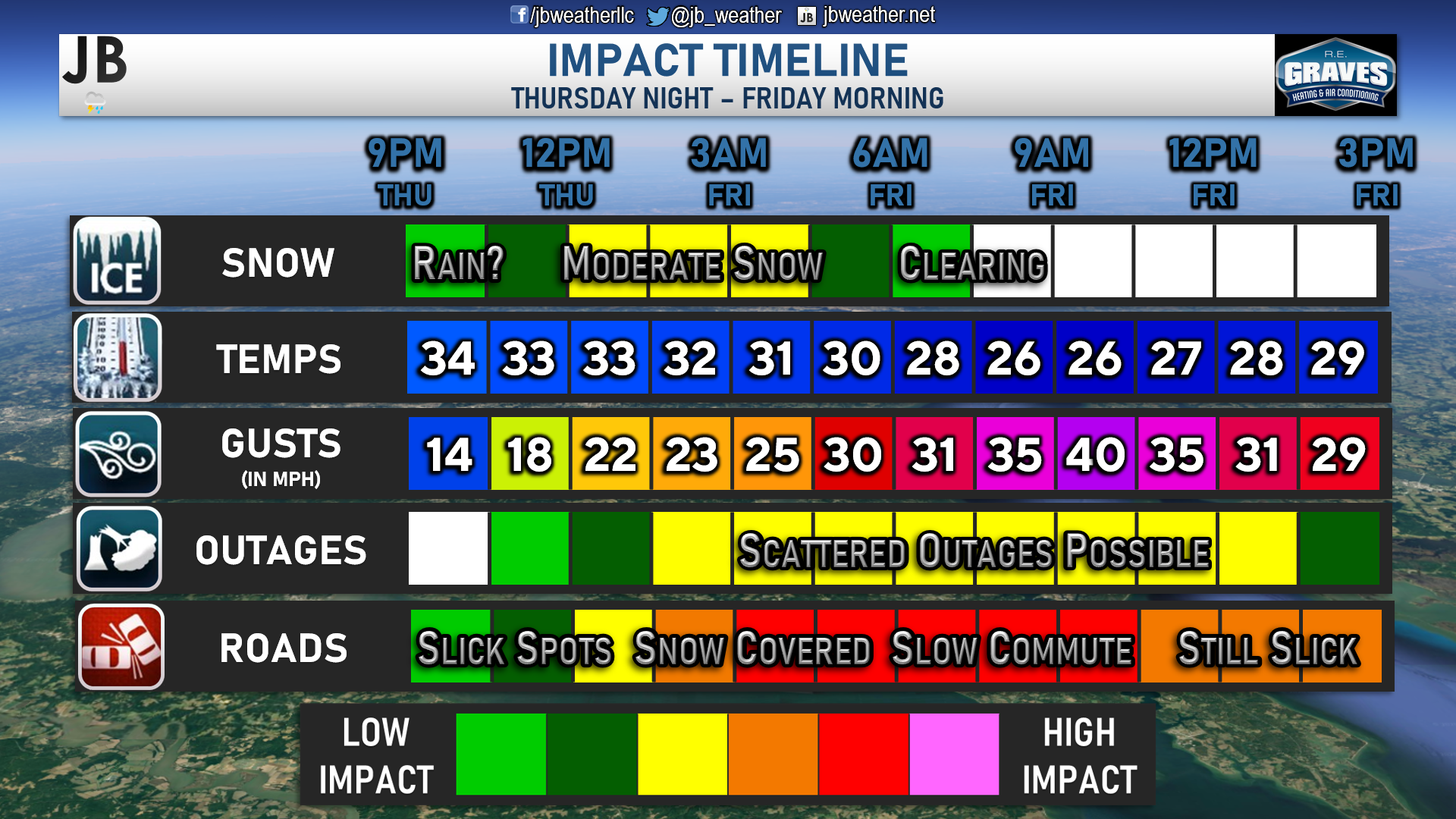
Overnight model guidance suggests that our storm may be delayed by a couple of hours in delivering precipitation to the region. Our latest run of Futurecast has precip moving in around midnight, which is a delay from 8-10pm start time we saw yesterday. You can see my expected snow start time on the graphic above.
Aside from a later start time, our Chesapeake’s Bounty Futurecast has been relatively consistent with the details of this storm. Shown below is a loop of our model. While we may see some initial area of rain or sleet across the region, everyone should quickly go over to snow. Futurecast suggests that we could see some moderate to heavy bands of snow set up across our local area. However, this is a quick-moving storm. We will likely see the precipitation wrap up by sunrise, between 4-7am. The quick pace of this storm will prevent it from putting down the significant totals we saw on Monday.
Accumulation Maps
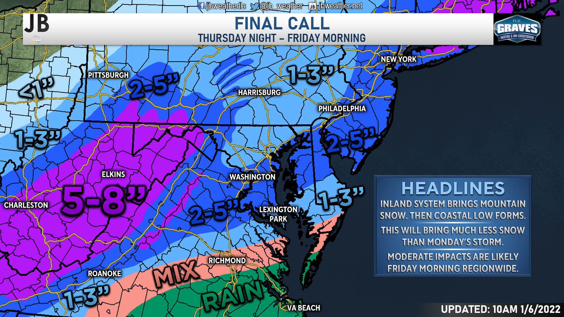
I am forecasting for much of the Mid-Atlantic to see accumulating snowfall tonight into tomorrow. The heaviest snow is likely to be found out west in the southern Appalachians, where 5-8″ of snow looks likely. They will see the bulk of their snow from the initial area of low pressure that will traverse the Mid-South later today. That area of low pressure will then die as it approaches the mountains, and transition its energy to the coast where it will form a new coastal low. This second system is what will likely bring much of our snowfall locally. We are likely to see a stripe of 2-5″ of snow extending from the mountains, through the southern DC metro area, and along the Atlantic coastline. Temperatures will look to remain too warm across central and southern Virginia for much more than just a mix, leading to less than an inch of accumulation.
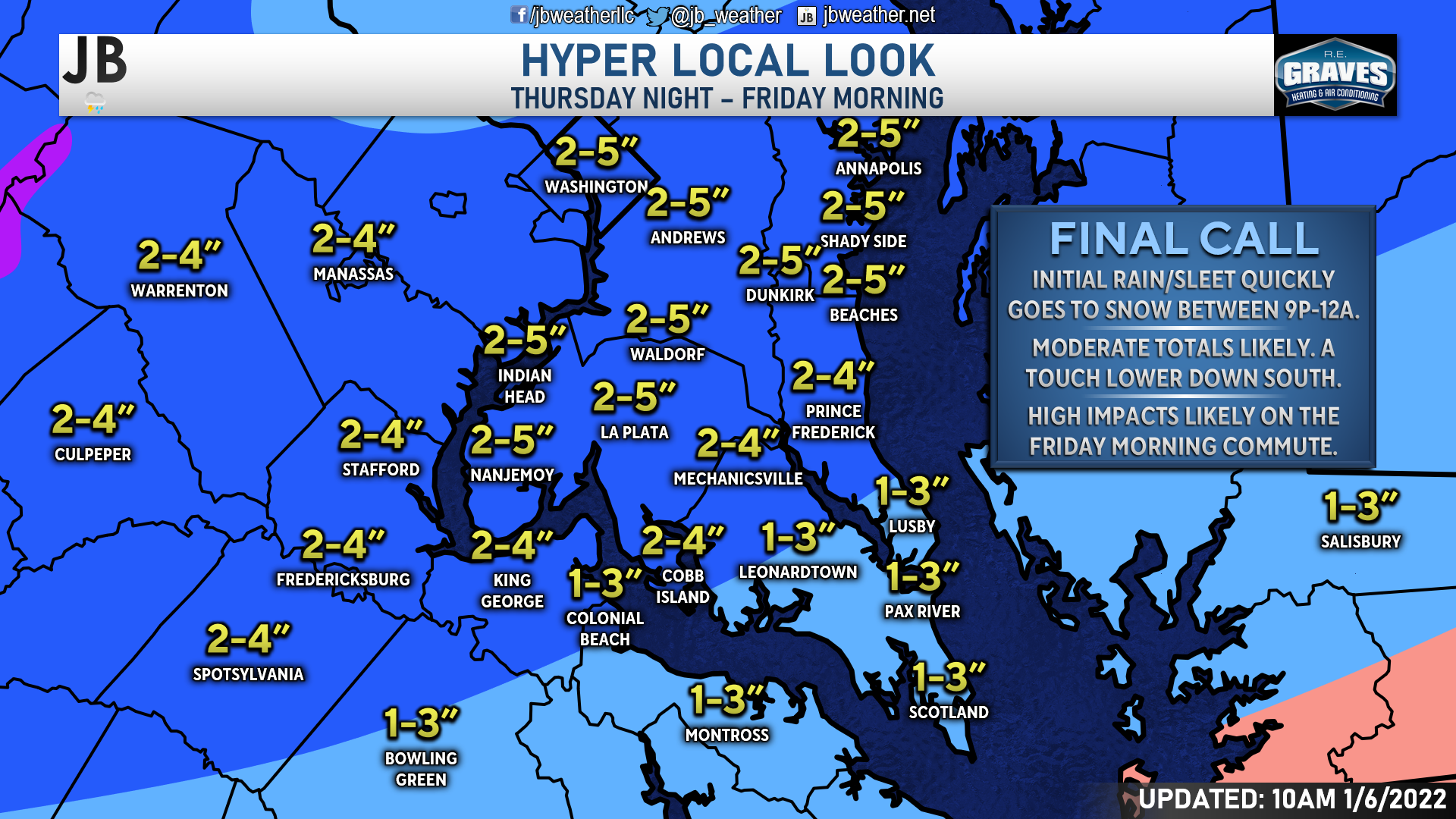
Locally, we will see that band of 2-5″ be placed across much of our local region. When we break this down a little further, I think that we will see a stripe on the higher side of the 2-5″ range from about Huntingtown-La Plata-Nanjemoy northward to about DC to Annapolis, south of Route 50. This zone looks to be where heavier snow bands may set up and bring 1″ an hour snowfall rates. If this band ends up developing further north, then we would be on the lower side of this range, and areas closer to Baltimore would see these higher totals. South of Prince Frederick and La Plata, I think 1-3″/2-4″ of snow looks likely. While those two ranges are pretty similar, you will the 1-3″ totals the further south you head. While this region will still see impactful snowfall, we may not see the heaviest bands of snow set up this far south. If they do, you would be on the higher side of the ranges I have. Devil’s in the details, and trying to narrow down the small corridor of the heaviest snows is always tricky.
Regional Impacts
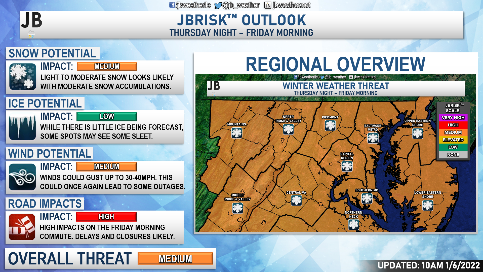
Regionally, I expect medium impacts for most areas. This storm does not look to be a significant winter storm for the region, but it will be modest. We will see medium impacts from the moderate snowfall. I am not expecting any ice impacts. We likely will not see any sleet or freezing rain areas develop for a sustained amount of time.
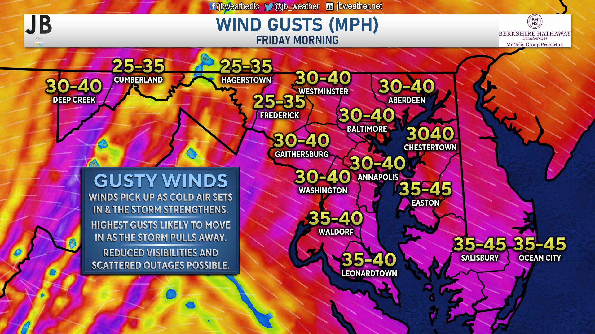
We will see medium impacts from the wind. Winds will begin to pick up as the storm departs from our region and begins to strengthen. This strengthening will pull in energy and cold air around it, leading to increased wind gusts. I think that by mid-morning, we could see 30-40mph wind gusts across the region, with some localized spots seeing gusts up to 45mph. These winds could, once again, lead to some power outages. However, I would not expect outages on the level we saw with Monday’s storm.
Air and ground temperatures are cold enough to allow whatever snow falls to stick. These temperatures will lead to rapid accumulations on both grassy and blacktop surfaces. While the snow will be out of here before the morning rush, the impacts of snow and slick spots on area roads will lead to high travel impacts. Thankfully, road crews have treated the roadways ahead of this storm, which they couldn’t do before Monday’s storm. But I would still expect snow-covered roads, including our major roads (such as Routes 4, 2, 235, 231, 301, 5, 6, etc.). These impacts are likely to be felt region-wide.
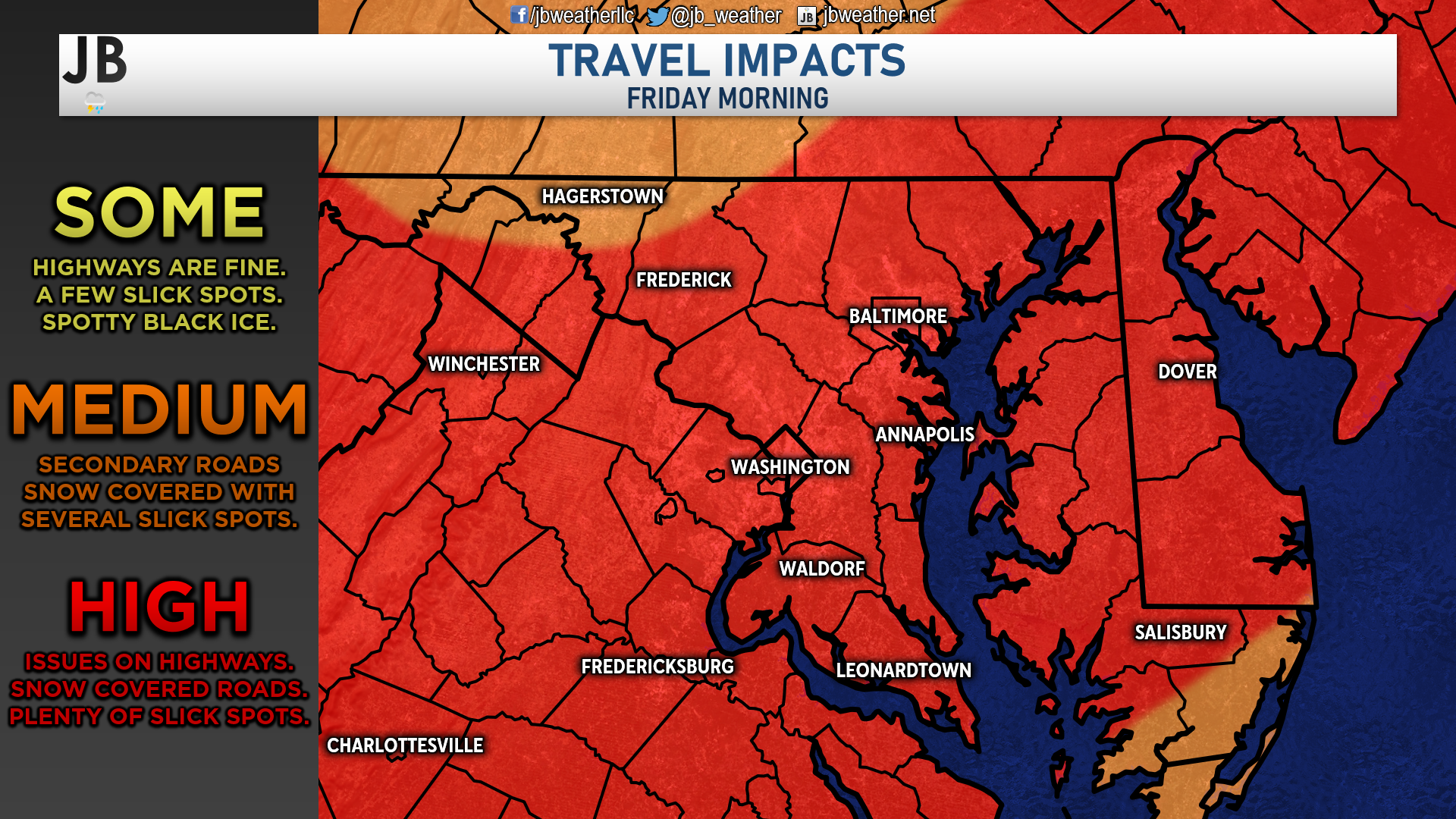
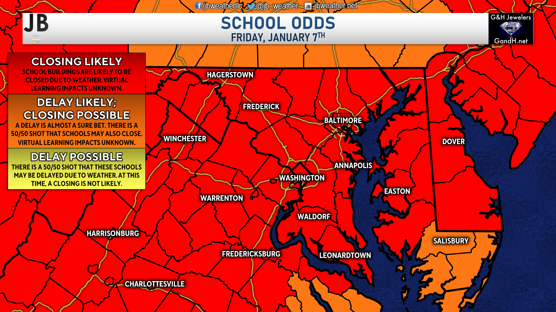
With this in mind, my School Odds outlook calls for many area schools to be closed for tomorrow. While this does not factor in virtual learning, I would expect the buildings to be closed for students and most staff.
Storm FAQs
How confident are you in your forecast? My confidence in this forecast is high. It looks very likely that we will see a system bring precip to the region Thursday night into Friday morning. It is also very likely that we see cold air move in Thursday night, to ensure that most of what falls is snow. The only caveat to this forecast is where the band of heavier snow sets up, which I have lower confidence about.
Will this event be like Monday’s storm? No. While the track looks similar to Monday’s storm, this system will be moving much quicker and be much weaker. Both of those factors will limit the duration of precipitation and how heavy the precipitation can be.
Where will the heaviest snow fall? The highest snow totals will be in the Mountains and in a narrow band that will likely set up between Annapolis and Prince Frederick. This band may set up north or south of this region (it is notoriously hard to forecast these mesoscale bands), but I think this is where it may likely be. Where it sets up, you may see some communities get near 5″, or even 6″.
Will this be heavy, wet snow or dry, powdery snow? With temperatures hovering right around freezing throughout this event, we are likely to see heavy, wet snow. Granted, this is not likely to be as moist as Monday’s snow, which should make it a touch easier (but not easy) to shovel.
When will the snow start? Current guidance shows that the snow may begin west of I-95 by 8-11pm and across southern Maryland between 9pm-12am.
When will the heaviest snow fall? The moderate bands of snow are likely to set up and move through between 1-4am. That is a short time frame with the moderate snow, but the cold air will help ensure that whatever falls will stick.
When will the snow end? The storm looks to be out of here by sunrise on Friday, likely between 4-7am. Granted, impacts will linger throughout the day on Friday.
How much snow will I get at my house? Check out the accumulation map. Generally, I’m expecting 2-5″ for most of the region.
Could more or less snow fall than currently forecast? Absolutely. In order for more snow to happen, we would need the storm to slow down, to increase the duration of precipitation, and to be stronger, to increase the amount of precipitation that can fall. It is not likely that we will see significant changes in either category from what I am forecasting right now. If the storm were to move quicker, be weaker, or feature less cold air moving in, then we could see lower totals. I feel confident that we will have enough cold air present, but it is possible that we see the storm move quicker. In light of these plausible scenarios, here’s my assessment of snowfall probabilities:
10% chance: Less than an inch
20% chance: 1-2″
45% chance: 2-4″
25% chance: 4-6″
As you can see, I feel pretty confident that we will see at least a couple of inches of snow across the region Friday morning. The chances of seeing less than an inch are very low, around a 1 in 10 chance. There is a 1 in 4 chance that some spots see upwards of 6″, but it likely would not be regionwide.
Will the snow stick? It is likely that we see snow accumulation on both grassy surfaces and on roadways. The recent cold shot after Monday’s storm has helped to really bring down ground and road temperatures. I think the snow will have no problem sticking as soon as it falls, which is what will lead to area-wide issues.
Any chance of a wintry mix of freezing rain or sleet? The threat of freezing rain or sleet with this storm is low. Some spots may see a quick burst of sleet as we transition over to snow late Thursday night. However, I highly doubt that we will see any impactful ice accumulations. At most, there may be a quarter-inch layer of iced-over slush on blacktop surfaces before the snow falls.
Summary
All-in-all, it does look likely that we will see our second snowfall this week, late Thursday into early Friday. However, I am not expecting this to mirror Monday’s event at all. This storm is moving much quicker and will be weaker than the system on Monday. However. a decent 2-5″ of snow looks likely across the region. We are likely to see high impacts as we head into Friday morning. Roads are likely to be snow-covered, and some scattered power outages are yet again possible thanks to gusty winds. I would expect regionwide delays and closures for Friday as a result. We will need to monitor how fast the system moves and how strong it gets. Both will play significant roles in determining how much snow does indeed fall and what the impacts could look like.
Stay with JB Weather for the latest information on impacts here in Southern Maryland. You can always access my forecasts and updates here on the website, on Facebook, on Twitter, and on YouTube. JB Weather is Southern Maryland’s Weather Leader, and I am working around the clock to keep you ahead of any storm!
-JB

R.E. Graves Heating & Air Conditioning is a ⭐️⭐️⭐️⭐️⭐️ HVAC Contractor serving St Mary’s & Calvert. Just mention JB Weather to Save 20% off your next Heating repair bill when you Book now! regraveshvac.net/jbweather20off.
John Bordash
View More PostsJB Weather forecaster John Bordash is working around the clock to provide Southern Maryland, and neighboring communities, with accurate and reliable weather information.