Brought to you by Berkshire Hathaway HomeServices McNeils Group Properties.
This morning Elsa is back down to tropical storm status, and is nearing the Florida coastline. A landfall along Florida’s Big Bend coastline is likely later this morning. Elsa will weaken quickly as it races to the north, just to the southeast of us. Our guidance has been shifting west, and it looks likely that Elsa will track far enough west to moderately impact Southern Maryland and the Northern Neck Thursday night.
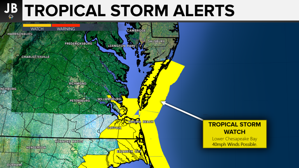
Tropical Storm Watches have already been posts for lower portions of the Chesapeake Bay. These will be the locations that are the most likely to see tropical-storm-force winds, of at least 39mph, Thursday night. These are also the areas that could see coastal inundation from the onshore flow.
Local Forecast
Futurecast really depicts well how I expect the arrival of Elsa to look. Some initial bands of showers/storms may move through during the afternoon. The core of Elsa will not begin to impact the area though until after sunset. Futurecast shows areas of heavy rain and gusty winds between 10pm – 2am. This will be a quick-moving system, so it’ll likely be out by sunrise Friday. Our Futurecast model only goes out 48 hours, and it not able to capture the entire event. But this does give you a good handle on what to expect.
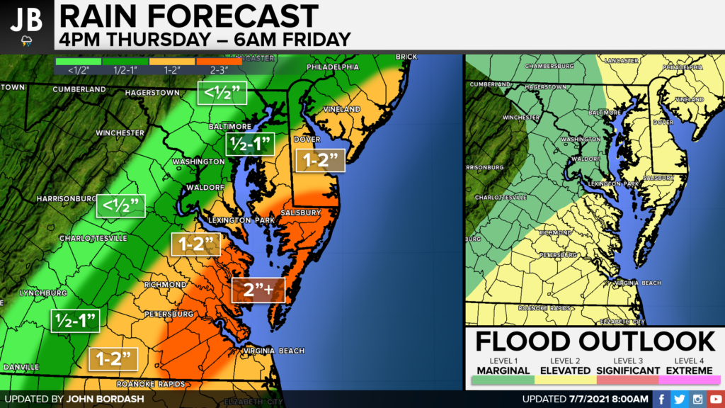
As we saw on Futurecast, the heaviest rains are likely to fall along, and just east, of the track of Elsa. With this in mind, I think areas of southern Calvert & St. Mary’s Counties, and the Northern Neck, will see 1-2″ of rain. Areas just to our east will likely have areas that see 2″+ of rain. Any additional westward tick in the track will move that heavy rain zone further west. This is a quick mover, so we should not see the rain we did from Isaias last year. With that said though, we will have an elevated flooding risk!
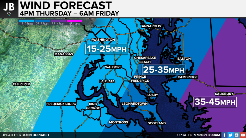
Like with the rain, the highest winds will likely be along and just east of the track. The Delmarva will look to see tropical-storm-force winds, between 35-45mph. Our southern areas will likely see 25-35mph, with some gusts to 40mph– especially in far southern St. Mary’s County. The winds will tapper greatly as you head north and west. Winds with Elsa should not be nearly as bad as they were with Isiais. We also should have a lower tornado threat as well. However, I cannot totally rule out one or two quick spin-up tornadoes or waterspouts along our coastal locations.
Summary
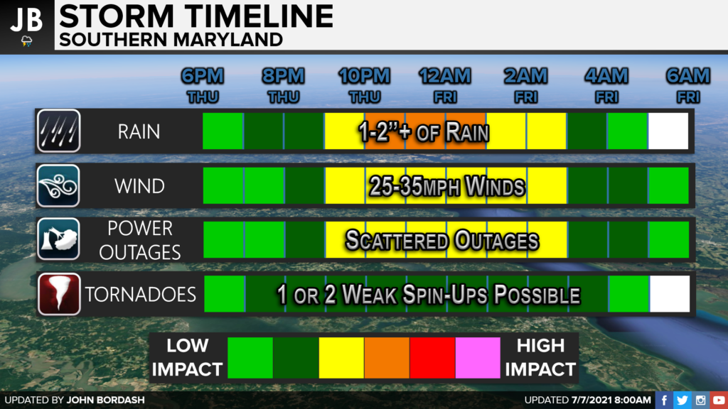
Elsa looks likely to swing through our region Thursday night. Elsa does not look to be as bad as Isaias was last year. With that said though, we will see some moderate impacts, especially for our southern communities. Shown above is a storm timeline that nicely shows the timing of specific impacts. I think we have the potential to see 1-2″ of rain and 25-35mph winds, with the peak of both occurring overnight. We will have the threat of some scattered outages, especially for coastal communities in southern St. Mary’s County. I also cannot rule out a weak spin-up or two overnight. Elsa will be a quick mover, likely clearing the region before sunrise Friday. This forward motion will help to lower our impacts a tad. However, any additional shifts westward could lead to increased impacts.
It will be important to stay with JB Weather for the latest information on Elsa and her important impacts here in Southern Maryland. You can always access my forecasts and updates here on the website, on Facebook, on Twitter, and on YouTube. JB Weather is Southern Maryland’s Weather Leader, and I am working around the clock to keep you ahead of the storm!
-JB
Brought to you by Berkshire Hathaway HomeServices McNelis Group Properties. Real Estate now! Not sure where to start? View our Southern Maryland inventory of homes, land, farms and commercial properties on mcnelisgroup.com. Engage with our planning tools to determine your next real estate lifestyle decision, choose your realtor as a trusted advisor. Experience the difference with service and support from real estate’s forever brand!
John Bordash
View More PostsJB Weather forecaster John Bordash is working around the clock to provide Southern Maryland, and neighboring communities, with accurate and reliable weather information.


3 thoughts on “Remnants of Elsa to Impact the Region”
Comments are closed.
[…] [ July 7, 2021 ] Remnants of Elsa to Impact the Region Breaking Weather […]
What is in the forecast for storm surge along the Western shore of the chesapeake?
Storm surge will likely not be an issue with this storm give it’s fast forward speed. At most, we may see one foot of water rise across the Lower Bay!
-JB