Brought to you by Chesapeake Orthodontics
Our region ended meteorological Winter with a rainfall deficit of about an inch. We made some of that up on Wednesday as we saw between a half-inch and an inch of cold rain. We will look to close up the rainfall gap on Saturday as an impending system looks to bring a wide variety of impacts to the region.
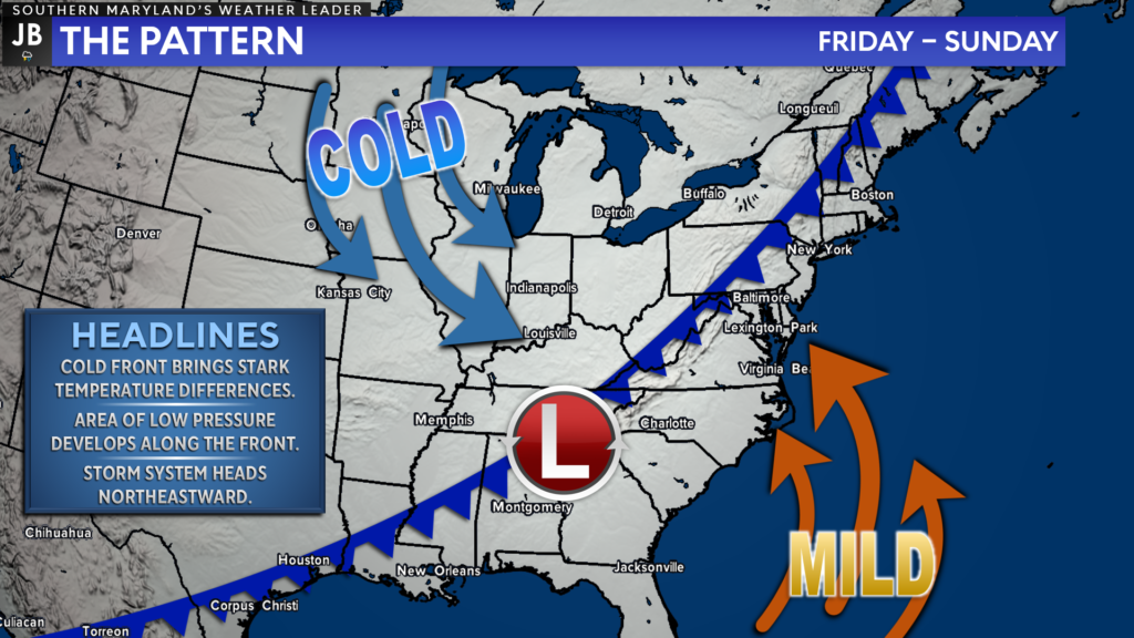
The weather on Friday should be quiet and seasonal ahead of this next system. A cold front that is draped across the country is making its way eastward and should arrive in our region by Saturday. As the front moves east, a storm system will develop along it, and move northeastward.
This cold front will offer a stark contrast in temperatures along it. Ahead of the front, temperatures are likely to be in the 50s and 60s! Behind the front, temperatures quickly fall off into the 20s and 30s. This will set the stage for an interesting setup as this system rides northward along the front.
This dynamic duo of the cold front and the developing system will bring an array of impacts to the Mid-Atlantic. Rain, storms, wind, and even snow are all possible on Saturday as we see this duo move through.
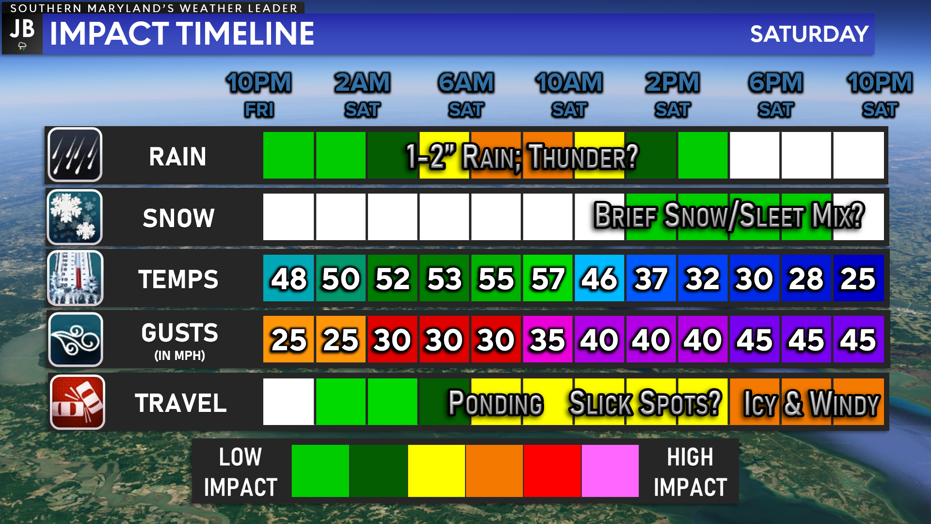
After a quiet weather day on Friday, we will likely see clouds increase after sunset as our system moves northward. Rain is likely to break out around midnight, with periods of moderate to heavy rain looking possible by sunrise on Saturday. There may even be some embedded storms associated with the bands of rain that move through.
While this system brings moisture northward, cold air will be filtering in from the northwest. This will allow for rain to gradually turn to snow across much of the Mid-Atlantic throughout the day. The snow threat is the highest across the mountains, where snow is likely to last the longest. As cold air filters in throughout the day, that changeover to snow may even make it down to the coastal plain by the afternoon!
Now, that we have an overview, let’s break down these multiple risks.
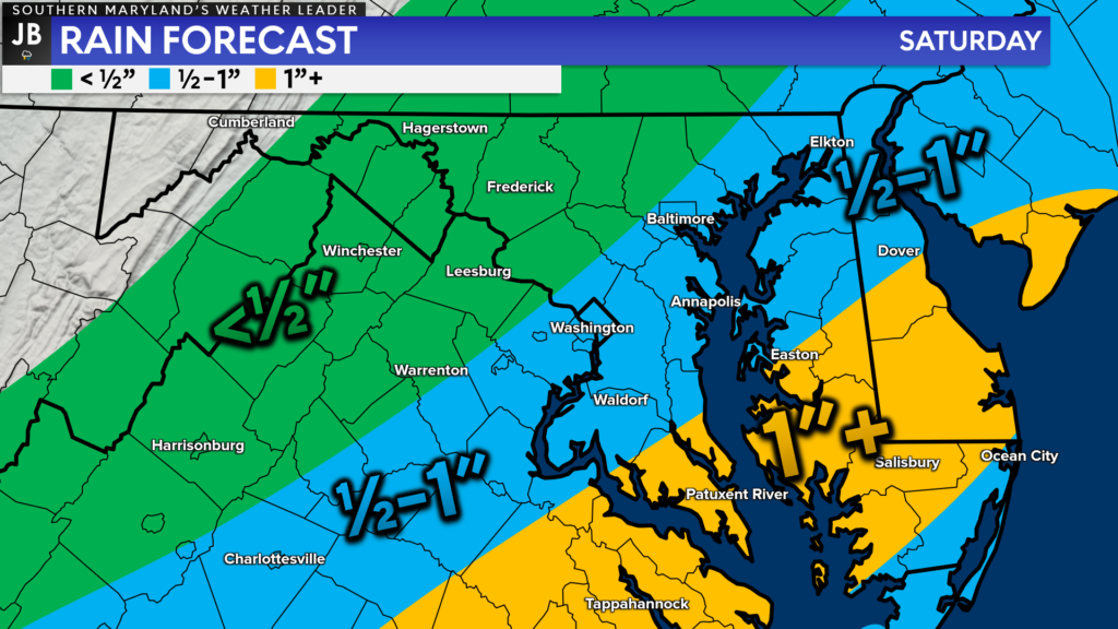
Rain: We are likely to see a lot of precipitation move through the Mid-Atlantic on Saturday. Much of this precipitation is likely to be rain along and to the southeast of I-95. The further southeast you head, the higher the rain totals.
Parts of Southern MD and Tidewater VA could see as much as an inch of rain on Saturday. The heaviest of this rain is likely to fall Saturday morning, centered around sunrise. While I am not concerned about a widespread flooding risk, some localized instances of ponding are possible.
The heaviest rains are likely to move through Southern MD between midnight and noon on Saturday.
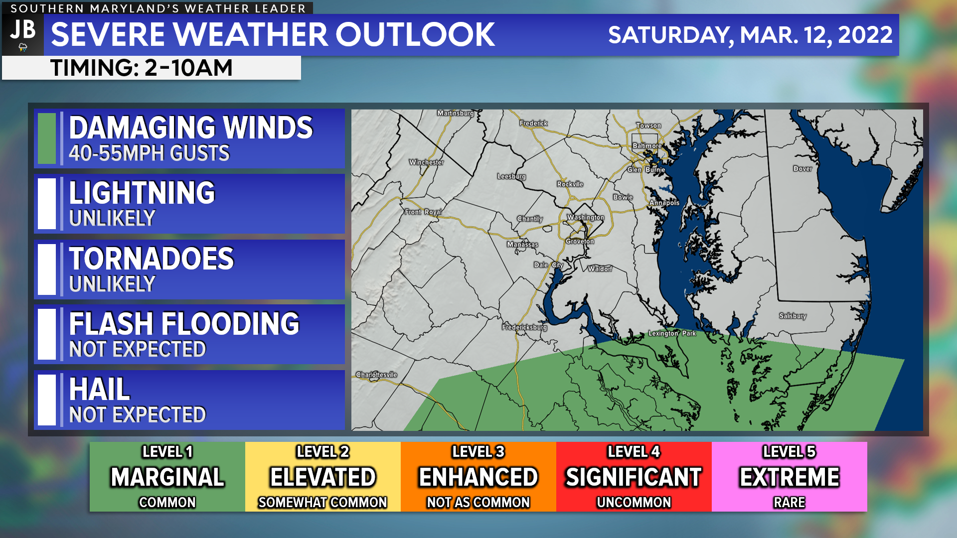
Storms: As bands of moderate to heavy rain work through the region Saturday morning, it is possible that we see some embedded storms also develop between 2-10am. As a result, the Storm Prediction Center has placed our southernmost communities under a Level 1 “Marginal Risk” for severe weather Saturday morning.
With a lack of storm energy, I do not think we are talking about a widespread storm risk. Rather, there will likely only be a couple of embedded storms. There will be a decent amount of wind energy, though. This means that the primary threat from any embedded storms would be wind gusts up to 40-50mph, along with enhanced rainfall. All other severe risks appear very low at this time.
If the developing storm system were to track further northwest, closer to the Appalachians, then our storm risk would increase. This would happen because we would see warmer temperatures move in, ahead of the cold front, allowing for increased storm energy. This would also increase the wind threat with storms. It remains to be seen if this will happen though. Nevertheless, this will be something to monitor Saturday morning.
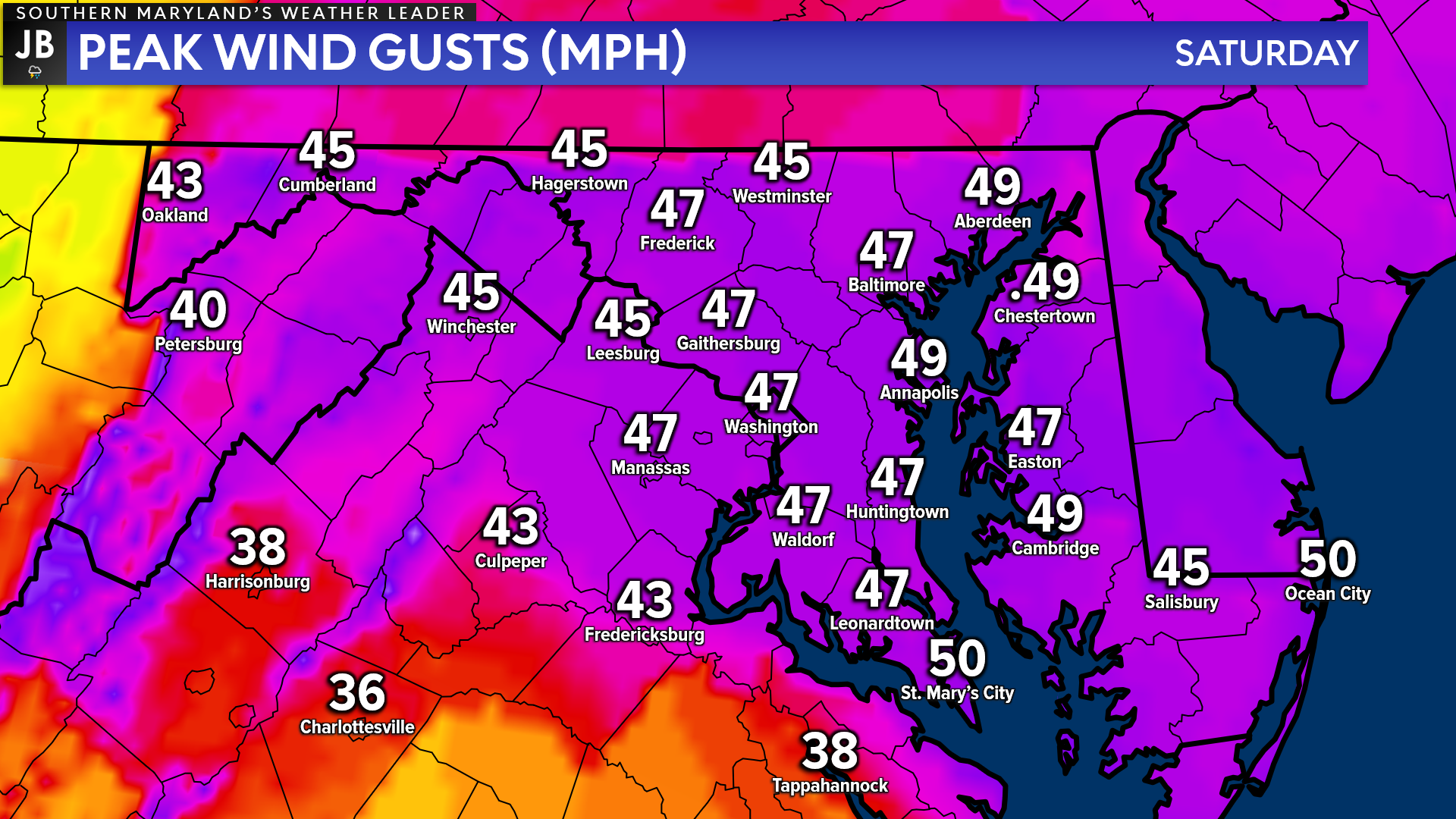
Wind: Aside from the thunderstorm wind threat, we will have a larger-scale wind threat on Saturday. We could see winds gust upwards of 40-50mph throughout the day on Saturday, especially in the evening.
Winds Saturday morning will initially come from the south, as warm air surges northward ahead of the front. This could usher in a minor-to-moderate coastal flooding threat. Then, as the front moves through late-morning, we will see winds switch, and come out of the northwest. These northwesterly winds will be quite strong as cold air filters in.
The highest winds will settle in by Saturday evening as the main system pulls away. There will be a sharp gradient on the backside of the system, enhancing the winds. This could lead to scattered power outages, especially for coastal communities. These winds will also usher in dangerously cold wind chills. Wind chills overnight Saturday could get into the teens for many.
Wind Advisories, and even some Wind Warnings, are likely to be issued at some point. To me, this is one of the biggest threats wit this system.
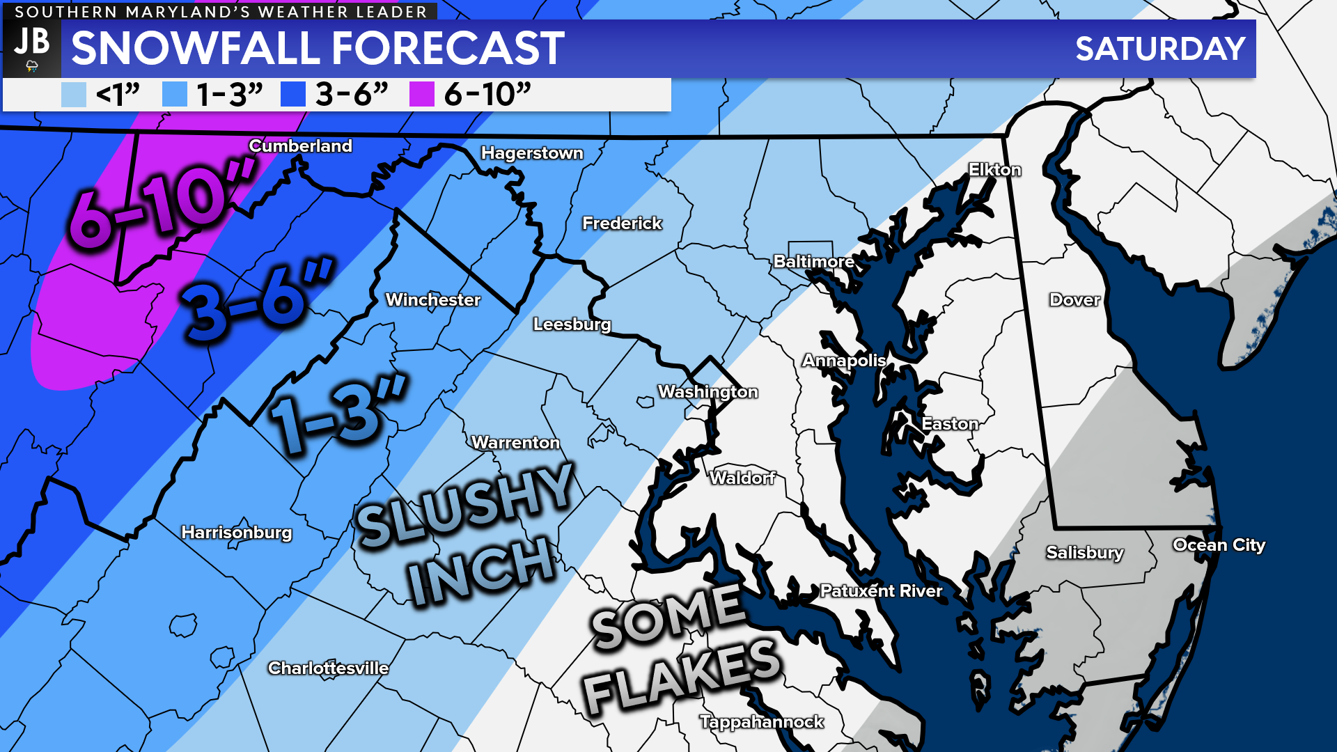
Snow: In addition to rain, storms, and wind, there will also be a snow threat with this setup. Granted, the highest snowfall risk will be well out to our west, across the Appalachians. The mountains will likely see mostly snow throughout this event, leading to several inches.
Throughout the day on Saturday, we are likely to see temperatures fall quickly as cold air rushes in from the northwest. Temperatures look to fall enough to switch many areas over to a period of snow by Saturday afternoon.
The northwestern DC suburbs may be able to squeeze out a couple of inches of slushy accumulation on the backside of the system Saturday afternoon. Areas along and to the southeast of I-95 could even see some snow fall as well. However, the game we are playing here is how quickly temperatures can fall before the precipitation moves out.
I am very skeptical about snowfall accumulations for the coastal plain on Saturday. The recent string of warm days and the heavy rain Saturday morning will make accumulation very difficult, especially here in Southern MD. With that said though, it is very possible that we see an hour or two of non-accumulating snow fall between lunchtime and sunset on Saturday.
While we may not see snowfall accumulation in Southern MD, we could definitely see any wet spots on area roadways freeze up Saturday night. Temperatures will continue falling throughout the night, which could lead to a widespread black ice event by Sunday morning.
We are likely to see a very dynamic system impact our region on Saturday. It is entirely possible that we go from 50s with storms Saturday morning to a period of light snow Saturday afternoon!
Rain will push in early Saturday morning, with some embedded storms being possible. Up to an inch of rain looks possible. Cold air will then look to push in by lunchtime, which may switch rain over to a brief period of snow as the system moves out. Snow accumulation in Southern MD does appear likely, though.
Despite any changeover to snow Saturday afternoon, we are likely to see winds pick up big-time. We could see winds gust upwards of 40-50mph at times Saturday evening. This could lead to some power outages. The wind threat appears to be the biggest threat to Southern MD, followed by the heavy rain Saturday morning.
Moderate to high impacts from the weather are likely throughout the day on Saturday. Travel is likely to be impacted throughout the day as well.
Stay with JB Weather for the latest information on Southern Maryland weather. You can always access my forecasts and updates here on the website, on Facebook, on Twitter, and on YouTube.
-JB
Dr. Thomas Hao and Dr. Dylan Schneider offer comprehensive orthodontic services for all ages. Schedule your free consultation today. Visit www.SOMDBraces.com today for more information!
John Bordash
View More PostsJB Weather forecaster John Bordash is working around the clock to provide Southern Maryland, and neighboring communities, with accurate and reliable weather information.
1 thought on “Next System Set to Bring Wide Array of Impacts on Saturday”
Comments are closed.
[…] [ March 10, 2022 ] Next System Set to Bring Wide Array of Impacts on Saturday Severe Weather … […]