Brought to you by Bill Oosterink, Realtor
Over the several days we have been tracking the potential for a winter storm for mid-week. There was plenty of hype late last week surrounding this storm as shaky model guidance showed the potential of a big snow event. Our model guidance has come back down to Earth, and this system appears to be more of a weak, southern sliding event for Wednesday.
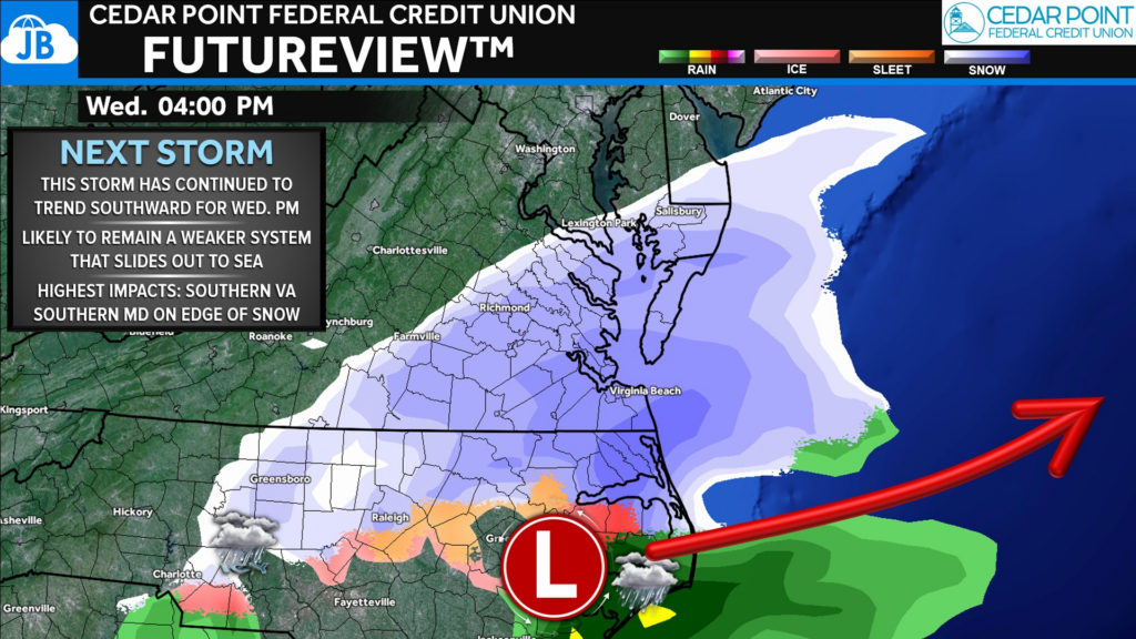
We are going to see a storm move out of the Mid-South late Tuesday into Wednesday. At the same time, we will see the Northern Jet Stream dip south to deliver a fresh injection of cold air. However, the Jet Stream will not interact and “caputure” our system, which would send it up the coast as a stronger system. Instead, the two look to stay separate, which would allow the system to slide out to sea as a much weaker storm.
This sort of track focuses the bulk of the winter weather impacts on southern Virginia and North Carolina. Southern MD is on the edge of seeing meaningful snow with very little north of DC. This is a far cry from the model outputs just 3 days that showed a widespread, heavy snowfall.
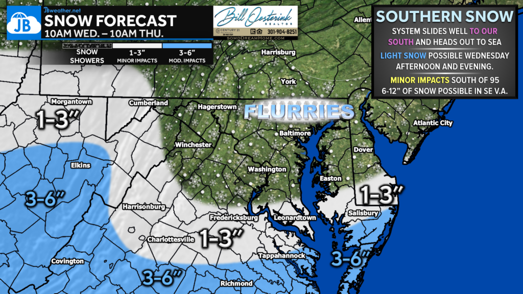
Right now, I would favor no more than 1-3″ falling south of Route 50 and Interstate 66. Honestly, one could argue that this 1-3″ zone through southern Maryland and central Virginia may be too far north. Nevertheless, more snow will fall to the south. 3-6″ looks possible across Tidewater Virginia, with 6-12″ possible for Hampton Roads. Areas north of DC may get in on some snow showers Wednesday night, but nothing too impressive.
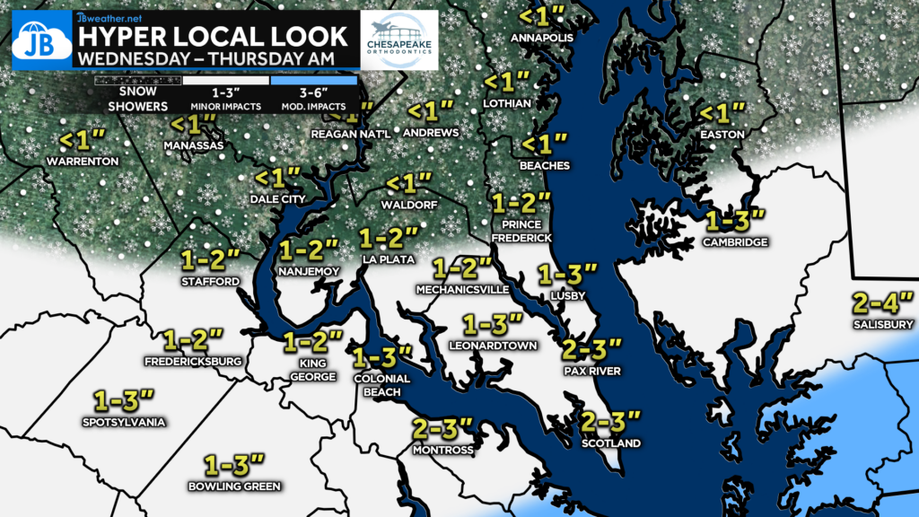
Locally, it will be areas south of the Benedict Bridge (stretching from Prince Frederick to Hughersville and La Plata) that have the highest odds of accumulation. 1-2″ looks likely across southern Calvert County, southern Charles County, St. Mary’s County and the Northern Neck. Up to 3″ could be possible south of Montross, VA and Lexington Park, MD. Areas southeast of Salisbury, MD, could pick up 3-4″, especially along the southern Delmarva peninsula.
Our Cedar Point Federal Credit Union Futureview model really does tell the story well. We will see moisture work eastward during the morning hours on Wednesday. But the cold and dry air will limit how much can fall. We should see snow reach the ground by late-morning south of DC. Periods of light snow continue off and on, especially to the south, through the afternoon before wrapping up Wednesday night. A secondary area of snow showers will be possible, but mainly west of I-95, Thursday morning.
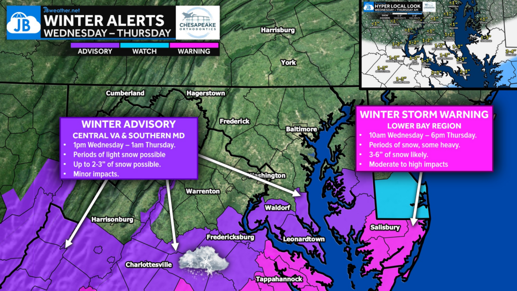
Much of Southern MD and Central VA has been placed under Winter Weather Advisories for tomorrow with the potential of 1-3″ of light snow. Winter Storm Warnings to our south where 3-6″ of heavy snow is likely.
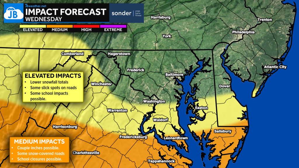
All in all, we are looking at a low-end system that could bring light snow on Wednesday south of DC. However, given model trends, even squeezing out 1-3″ south of DC may be hard to do. Nevertheless, if this forecast does pan out, we could see some impacts on Wednesday. Roadway accumulation will be possible, with impacts on travel and schools being possible.
As more information comes in, this forecast may continue to evolve. It is very possible that the snowfall forecast may need to get shifted even further south. If the last few days teaches us anything, it should be to avoid hype and clickbait! Stay with JB Weather for reliable information you can count on!
Stay with JB Weather for the latest information on impacts here in Southern Maryland and across the Mid-Atlantic. You can always access my forecasts and updates here on the website, on Facebook, on Twitter, on Instagram, and on YouTube. JB Weather is the Mid-Atlantic’s Weather Leader, and I am working around the clock to keep you ahead of any storm!
Buying. Selling. Investing. Ready when you’re ready! Check out www.somdDreamHome.com today!
John Bordash
View More PostsJB Weather forecaster John Bordash is working around the clock to provide Southern Maryland, and neighboring communities, with accurate and reliable weather information.
6 thoughts on “First Call: Southern System May Bring Light Snow Wednesday”
Comments are closed.
[…] First Call: Southern System May Bring Light Snow Wednesday […]
[…] Story continues […]
[…] First Call: Southern System May Bring Light Snow Wednesday […]
Thanks John ! you are my go to weather news love JB Weather!❤️❄️💨😎🌞⛈️
How will the separation of the Northern Jet Stream and the storm system impact the storm’s strength and path?
Regard PJJ Informatika
[…] First Call: Southern System May Bring Light Snow Wednesday […]