A cold front will move through the region Saturday night, with a coastal low attempting to rapidly develop offshore before pushing out early Sunday morning. This setup will bring an overnight period of snow to much of the Mid-Atlantic, beginning first across the mountains late Saturday afternoon before expanding eastward through the evening and overnight hours.
Current guidance suggests widespread light snow, with the best chance for more organized, moderate banding along and just east of I-95, especially from Baltimore northward toward Philadelphia during the overnight hours. Farther southwest, snow may struggle at times due to a dry slot developing across portions of central and northern Virginia and into southern Pennsylvania, which could temporarily reduce or shut off precipitation before the coastal low takes over.
Snow showers are expected to continue through the overnight period before gradually tapering off from west to east Sunday morning, with most areas seeing precipitation end between 7–10 AM. Southern zones, particularly closer to the Virginia Tidewater, may start as rain before transitioning to snow, further limiting totals.
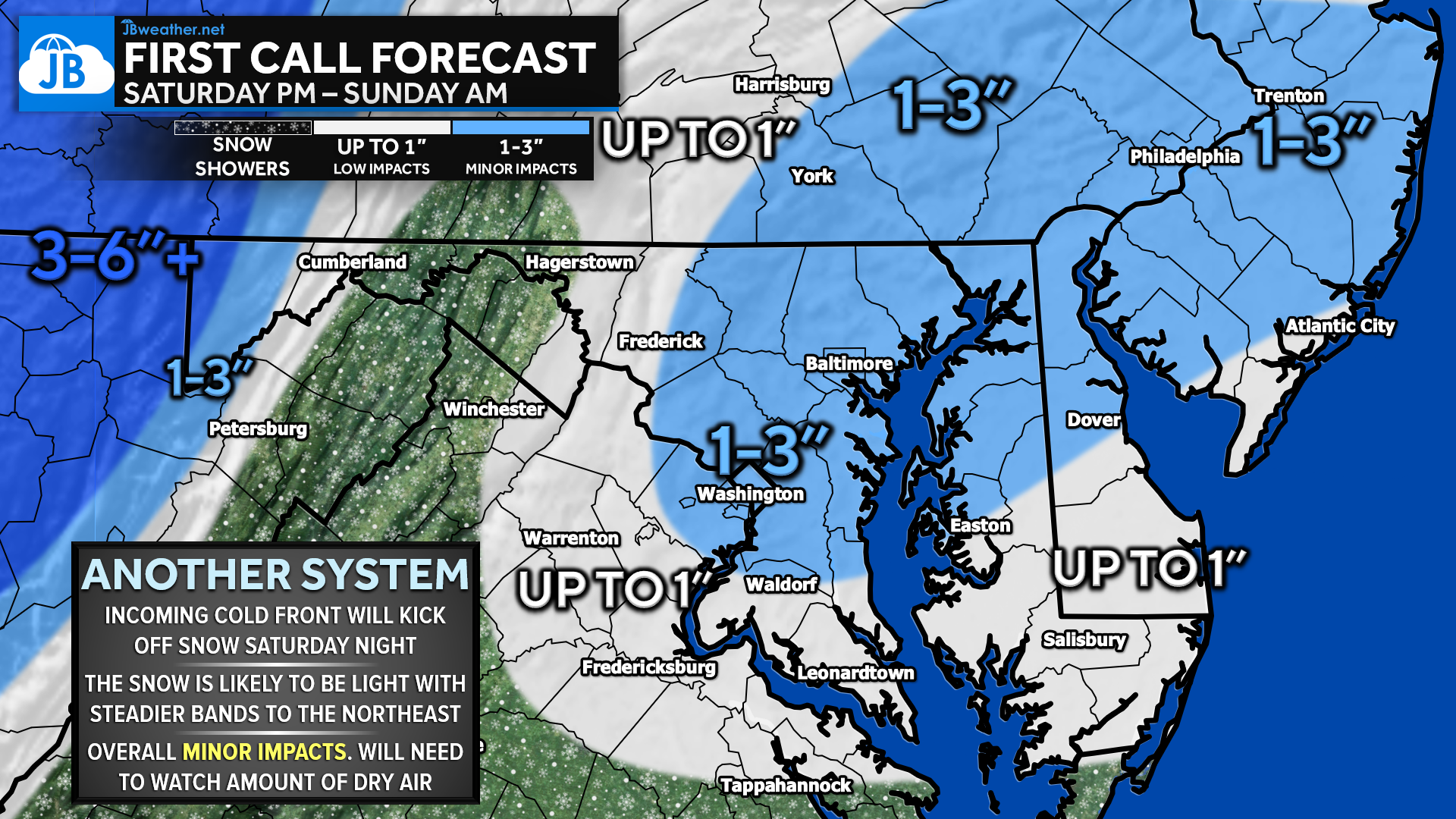
At this time, accumulations look modest, with 1–3 inches favored across northeastern zones, including parts of the I-95 corridor, and up to around 1 inch elsewhere. Confidence remains low to moderate, as this type of system is highly sensitive to dry air intrusion and exact coastal low placement. Because of this, forecast amounts here are intentionally on the lower side compared to some other projections, as there is concern that current guidance may be overestimating overall precipitation. This will be a system that needs close monitoring as we head into the weekend.
KEY TAKEAWAYS
- ❄️ Timing: Snow develops west to east late Saturday afternoon, becoming most widespread Saturday night, and tapers off Sunday morning (7–10 AM)
- 📍 Best Chance for Snow: I-95 corridor, especially Baltimore to Philadelphia, where steadier bands may briefly develop overnight
- 📏 Amounts: Generally light accumulations — 1–3″ northeast, up to ~1″ elsewhere
- 🌬️ Uncertainty: Dry air intrusion and dry slotting could limit snowfall, especially across central/northern VA and southern PA
- ⚠️ Impacts: Minor overall, but brief slick spots possible overnight and early Sunday
Stay with JB Weather for the latest information on impacts here in Southern Maryland and across the Mid-Atlantic. You can always access my forecasts and updates here on the website, on Facebook, on Twitter, on Instagram, and on YouTube. JB Weather is the Mid-Atlantic’s Weather Leader, and I am working around the clock to keep you ahead of any storm!
John Bordash
View More PostsJB Weather forecaster John Bordash is working around the clock to provide Southern Maryland, and neighboring communities, with accurate and reliable weather information.