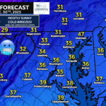
A cold northwest flow remains locked in across the region tonight, bringing chilly temperatures and gusty winds. While most areas stay dry, there is a low-end chance for spotty snow showers during the Wednesday morning commute.

Behind yesterday’s cold front, strong northwest winds will continue overnight, allowing colder air to filter into the region. This setup may support the development of light, scattered snow showers between roughly 3–7 AM Wednesday, especially across parts of the Baltimore–Washington metro, northeast Maryland, and southern Maryland. Coverage will be limited, and many areas may not see any snow at all.
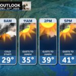
If snow showers do materialize, accumulations would be very light, generally just a coating, but even small amounts could briefly make roads slick in isolated spots. Impacts are expected to remain low overall, though a few communities could see localized travel issues during the morning rush. Commuters should remain aware of the possibility for icy patches and allow extra travel time where snow showers develop.
Stay with JB Weather for the latest information on impacts here in Southern Maryland and across the Mid-Atlantic. You can always access my forecasts and updates here on the website, on Facebook, on Twitter, on Instagram, and on YouTube. JB Weather is the Mid-Atlantic’s Weather Leader, and I am working around the clock to keep you ahead of any storm!
John Bordash
View More PostsJB Weather forecaster John Bordash is working around the clock to provide Southern Maryland, and neighboring communities, with accurate and reliable weather information.