A developing weather system over northeastern Mexico is drawing increasing attention from forecasters this week, not necessarily because of its tropical potential, but because of the significant flooding threat it poses for portions of Texas, Louisiana, Mississippi, and eventually parts of the Lower Mississippi Valley.
The National Hurricane Center (NHC) is currently monitoring a broad trough of low pressure over northeastern Mexico that is producing widespread showers and thunderstorms. While tropical development is not expected immediately due to the system remaining inland, it could emerge over the western Gulf by late Tuesday or Wednesday, where environmental conditions may support the formation of a short-lived tropical storm.
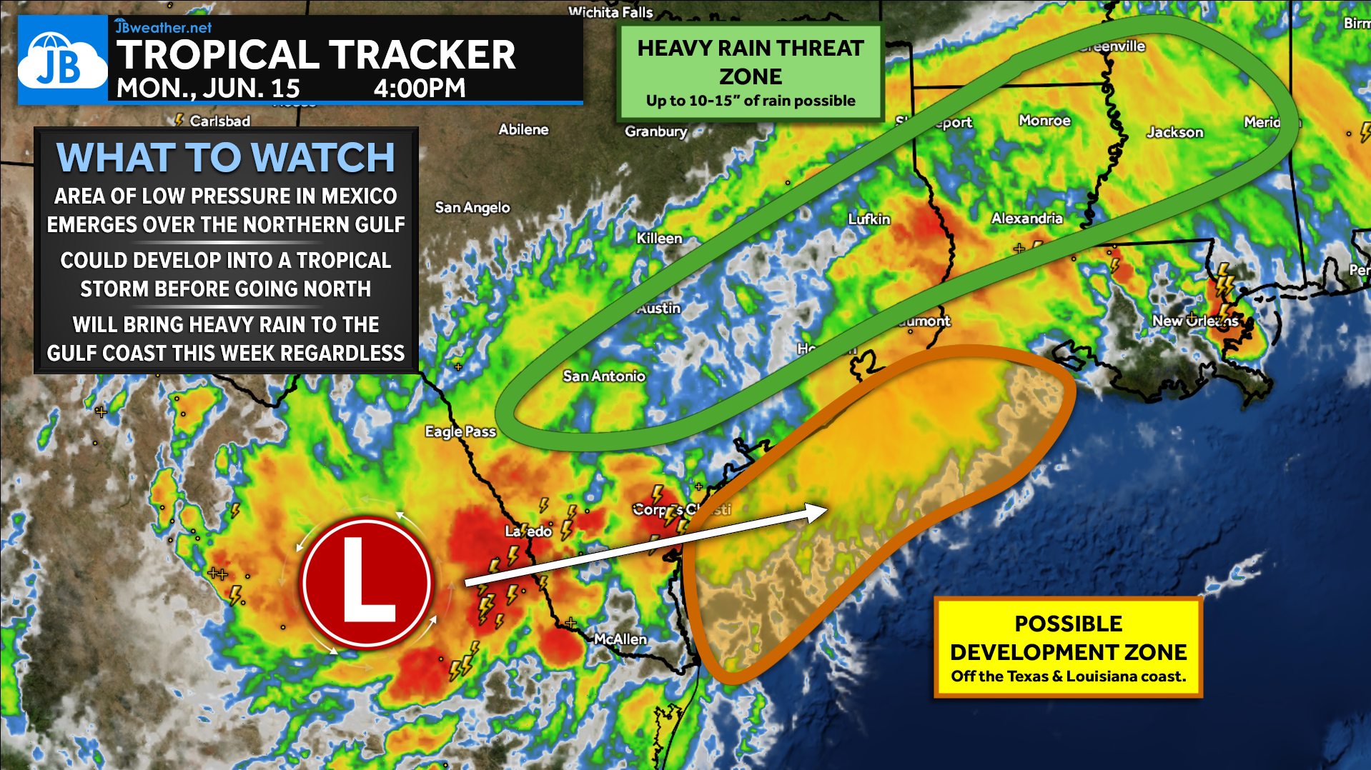
At this time, the NHC assigns the disturbance a 40% chance of tropical development over the next 48 hours and a 50% chance over the next seven days.
Tropical Development Remains Secondary Concern
While the possibility of a named storm is grabbing headlines, the more immediate and impactful threat is expected to be excessive rainfall.
The disturbance is interacting with several larger-scale weather features, including:
- An upper-level disturbance moving out of Mexico
- Deep tropical moisture pooling over the western Gulf
- A stalled frontal boundary draped near the Gulf Coast
This setup is expected to create a prolonged period of heavy rainfall, regardless of whether a tropical cyclone officially develops.
Current forecast guidance suggests that any tropical system would likely remain relatively weak and short-lived. However, even a weak tropical storm can produce devastating flooding when it becomes embedded within a moisture-rich environment and moves slowly.
Significant Flooding Threat Emerging
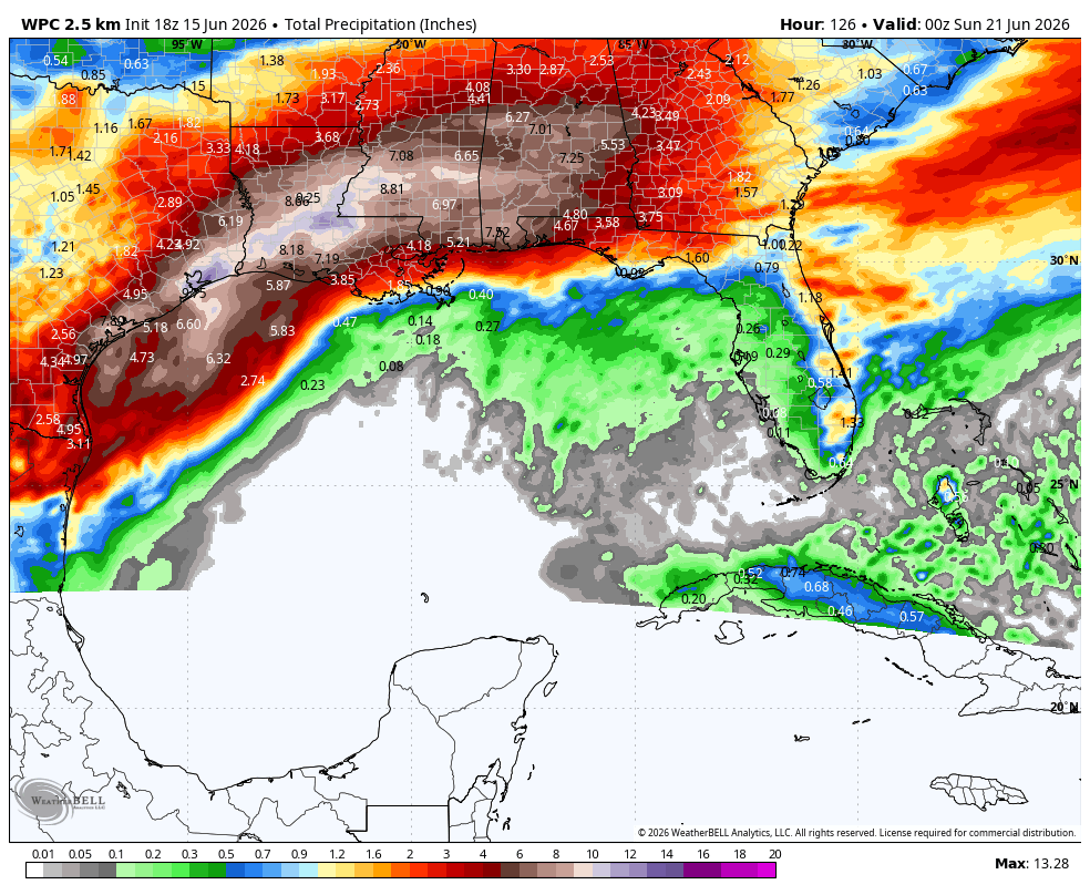
The Weather Prediction Center (WPC) continues to emphasize the risk for excessive rainfall from South Texas through Louisiana and portions of Mississippi.
Forecast rainfall totals through the middle and latter part of the week are expected to reach:
- 5 to 7 inches across a broad area
- Localized totals of 10 to 15 inches where rain bands repeatedly develop
- Potential for even higher isolated amounts depending on the eventual track and organization of the system
These rainfall totals would be spread across multiple days, but repeated rounds of tropical downpours could quickly overwhelm drainage systems and lead to dangerous flooding conditions.
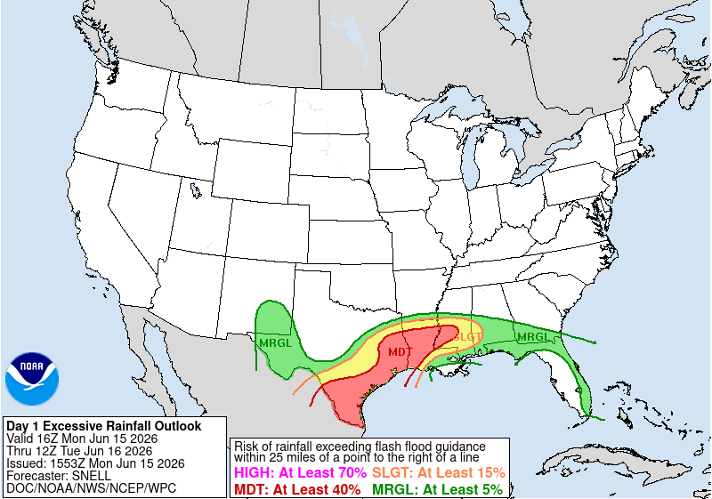
The highest rainfall corridor currently extends from the Texas coastline into Louisiana, though adjustments to the exact placement of the heaviest rainfall remain likely over the coming days.
Torrential tropical rainfall rates may exceed several inches per hour at times, leading to rapid flooding of streets, neighborhoods, and low-lying areas. Major metropolitan areas along the Gulf Coast could experience significant drainage issues if multiple heavy rain bands repeatedly move over the same locations. The prolonged nature of the event may eventually lead to rises on area rivers and streams, creating flooding concerns that could persist well after the heaviest rainfall ends.
Some Guidance Suggests the System May Continue Inland
While confidence remains low regarding the exact evolution of the disturbance, some ensemble guidance suggests the system may eventually move inland and track northeastward through the Deep South and toward the eastern United States.
The latest ensemble forecast below illustrates a broad cluster of possible tracks extending from the western Gulf Coast into the Southeast and eventually the Mid-Atlantic and Northeast.
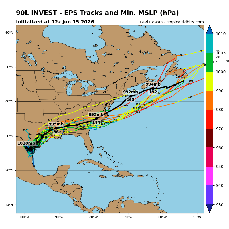
It is important to note that this graphic does not indicate a major tropical cyclone. Instead, it highlights the considerable uncertainty that remains regarding the exact path of the disturbance after landfall.
Regardless of its classification, a slow-moving remnant system could continue producing heavy rainfall well inland.
What Happens Next?
Over the next 24 to 48 hours, forecasters will be watching for:
- Whether the disturbance can organize after emerging into the Gulf
- The location of any developing low-pressure center
- How quickly the system moves northward
- Where the axis of heaviest rainfall ultimately sets up
If organization increases, Tropical Storm Watches or Warnings may become necessary for portions of the Texas and Louisiana coast as early as Tuesday.
Bottom Line
The name of the system may ultimately be less important than its impacts.
Whether this disturbance becomes a tropical storm or remains a broad area of low pressure, confidence is increasing that parts of the western and central Gulf Coast will experience several days of heavy rainfall capable of producing significant flooding.
Residents from South Texas through Louisiana and Mississippi should closely monitor forecasts this week, review flood safety plans, and remain prepared for rapidly changing conditions as the system develops.
The greatest threat appears to be flooding rainfall, not damaging winds. That distinction could make all the difference in how this event ultimately impacts the Gulf Coast.
John Bordash
View More PostsJB Weather forecaster John Bordash is working around the clock to provide Southern Maryland, and neighboring communities, with accurate and reliable weather information.