Brought to you by Chesapeake Orthodontics
A rare and potentially impactful severe weather day is expected across the Mid-Atlantic today as a powerful storm system pushes a cold front toward the region. The overall setup has changed very little overnight, and confidence remains high that storms will develop later today, especially during the afternoon and early evening. The biggest question this morning is how long early showers and clouds linger, which will determine how unstable the atmosphere becomes ahead of the front.
Today’s Forecast Setup
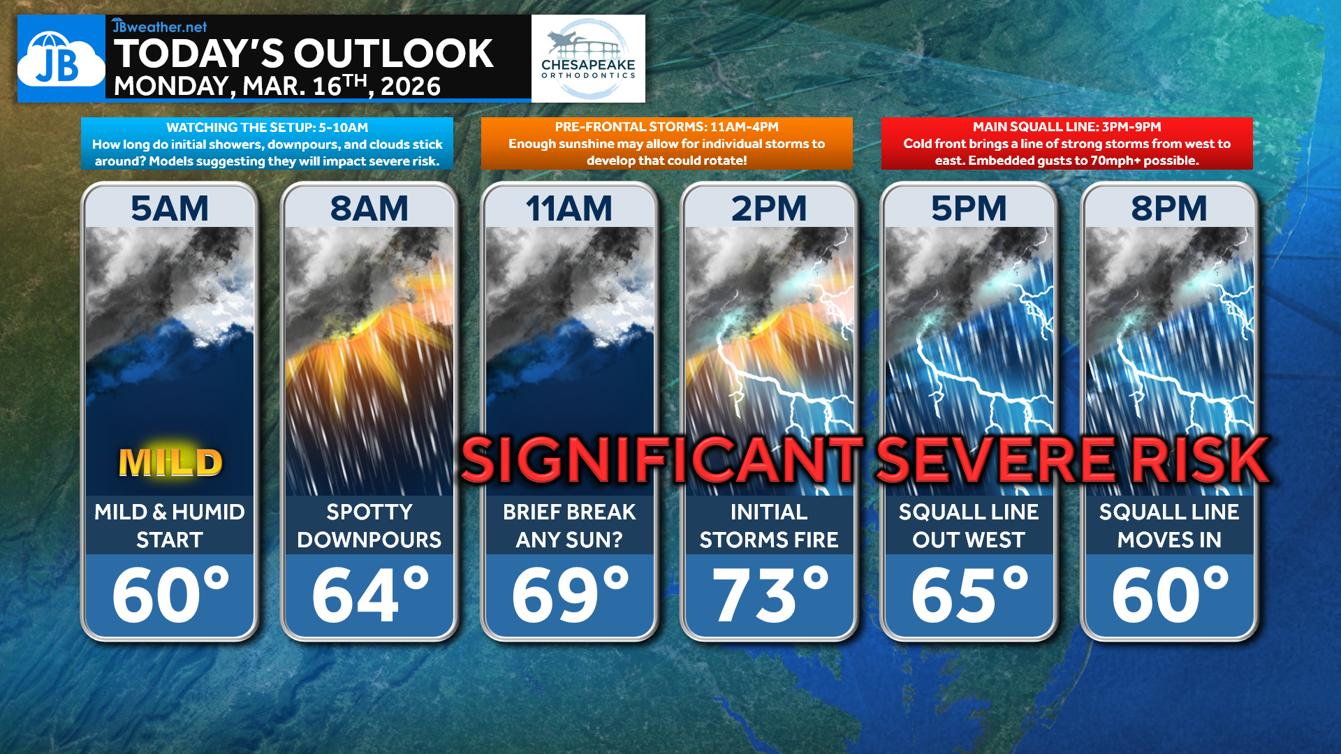
Today will unfold in several stages as the storm system approaches. The morning begins mild and humid with scattered showers and downpours, which will move through during the early part of the day. If these showers begin to move out late morning, breaks of sunshine could quickly allow temperatures to climb into the 70s, creating a more unstable atmosphere. That instability could allow isolated storms to develop around midday or early afternoon, some of which could rotate before the main line arrives.
FutureView Timing
Latest FutureView guidance continues to show much of the same overall scenario that we have been highlighting since yesterday. Morning rain gradually exits the region before the atmosphere begins to destabilize late morning into early afternoon. From there, isolated storms may develop ahead of the cold front, especially if clouds break for a time. The main event still appears to be a strengthening squall line forming to our west and pushing east through the region later this afternoon and evening.
One key factor we will continue watching closely is how quickly the morning rain and cloud cover clears out, since more sunshine would allow the atmosphere to become more unstable and support stronger storms.
Today’s Severe Risk
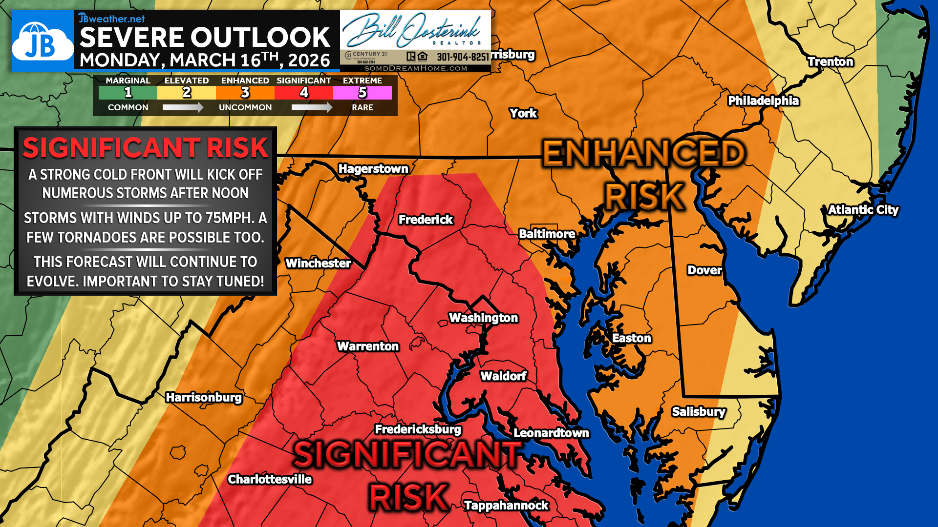
The Storm Prediction Center continues to highlight our region with a rare Level 4 “Significant Risk” for severe weather today. This is very uncommon for the Mid-Atlantic, and signals the potential for numerous severe storms across the region.
Damaging winds remain the primary concern, with storms capable of producing 70–80 mph wind gusts as the line moves through. There is also a rare 15% tornado risk, meaning a few tornadoes are possible — either from storms that develop ahead of the front or from quick spin-up circulations embedded within the main line.
Putting It All Together
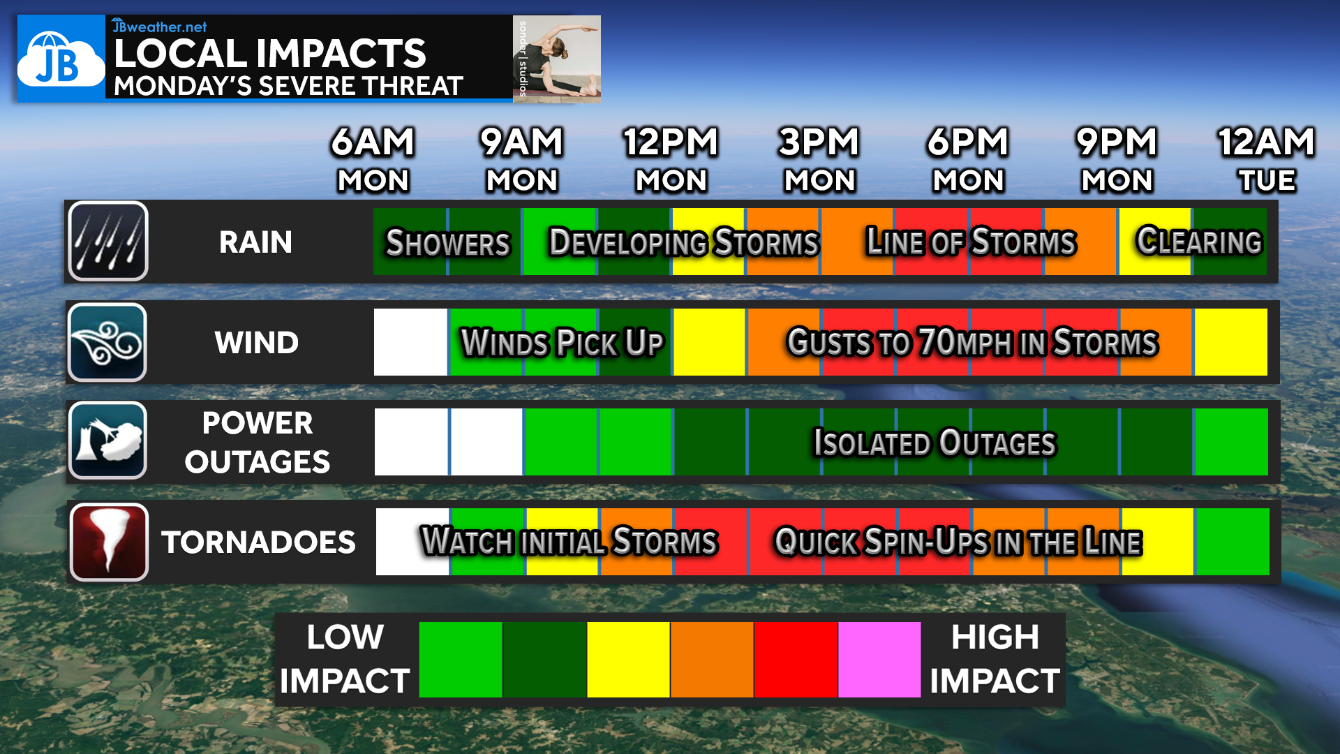
Today’s weather will likely evolve in stages. Morning showers will move through first before conditions begin to destabilize late morning into early afternoon. Isolated storms could develop around midday, especially if skies clear for a time. The highest impact period remains late afternoon into the early evening, when a strong line of storms moves through the region bringing the potential for damaging winds and isolated tornadoes.
While not everyone will see severe weather, this remains a rare setup for our region and one worth taking seriously. Stay weather aware this afternoon and evening and make sure you have a way to receive warnings if storms approach your area.
5-Bullet Summary:
🚨 Rare Level 4 “Significant Risk” for severe weather across the region today
🌧 Morning showers may clear late morning, allowing the atmosphere to become unstable
🌪 Isolated storms midday could rotate and attempt to produce tornadoes
💨 Main squall line arrives 3–8 PM with potential for 70–80 mph damaging winds
⚠️ Stay weather aware this afternoon and evening and have a way to receive warnings
Stay with JB Weather for the latest information on impacts here in Southern Maryland and across the Mid-Atlantic. You can always access my forecasts and updates here on the website, on Facebook, on Twitter, on Instagram, and on YouTube. JB Weather is the Mid-Atlantic’s Weather Leader, and I am working around the clock to keep you ahead of any storm!
Dr. Thomas Hao and Dr. Dylan Schneider offer comprehensive orthodontic services for all ages. Schedule your free consultation today. Visit www.SOMDBraces.com today for more information!
John Bordash
View More PostsJB Weather forecaster John Bordash is working around the clock to provide Southern Maryland, and neighboring communities, with accurate and reliable weather information.

