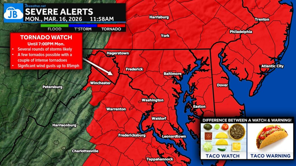
A Tornado Watch (red zones) is in effect until 7 PM EDT this evening for much of the state of Maryland, northern Virginia, southern and eastern Pennsylvania, New Jersey, and the Delmarva Peninsula.
Primary threats include…
- A few tornadoes are likely, with a couple of intense tornadoes possible
- Widespread damaging winds and isolated significant gusts to 85 mph are likely
- Isolated large hail events to 1 inch in diameter are possible
SUMMARY: Several bands and clusters of storms are expected to intensify through the afternoon, with the potential to produce swaths of damaging winds, some significant (75-85 mph), and embedded circulations will pose a threat for several tornadoes, some of which could be strong (EF2+).
REMEMBER: A Tornado Watch means conditions are favorable for tornadoes and severe thunderstorms in and close to the watch area. Persons in these areas should be on the lookout for threatening weather conditions and listen for later statements and possible warnings.
John Bordash
View More PostsJB Weather forecaster John Bordash is working around the clock to provide Southern Maryland, and neighboring communities, with accurate and reliable weather information.