A slow-moving cold front and developing coastal low will bring another round of widespread showers and thunderstorms to the region today. While not everyone will experience severe weather, portions of Southern Maryland, the lower Delmarva, and Tidewater Virginia will need to watch for locally heavy rainfall, damaging wind gusts, and even an isolated tornado this afternoon and evening.
Temperatures will be dramatically cooler than Monday, with clouds and rain holding most locations in the 70s. The greatest concern will be from midday through early evening as the front interacts with very humid air and a strengthening disturbance aloft.
Today’s Forecast
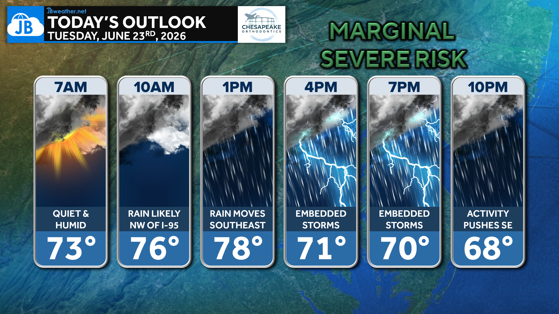
The day starts relatively quiet and humid before rain expands across the region through the morning. By midday and afternoon, showers become widespread with embedded thunderstorms developing along and ahead of the cold front.
The overall trend will be for rain and storms to shift southeast through the afternoon and evening before exiting offshore tonight.
Overall Setup: Cold Front Meets Developing Coastal Low
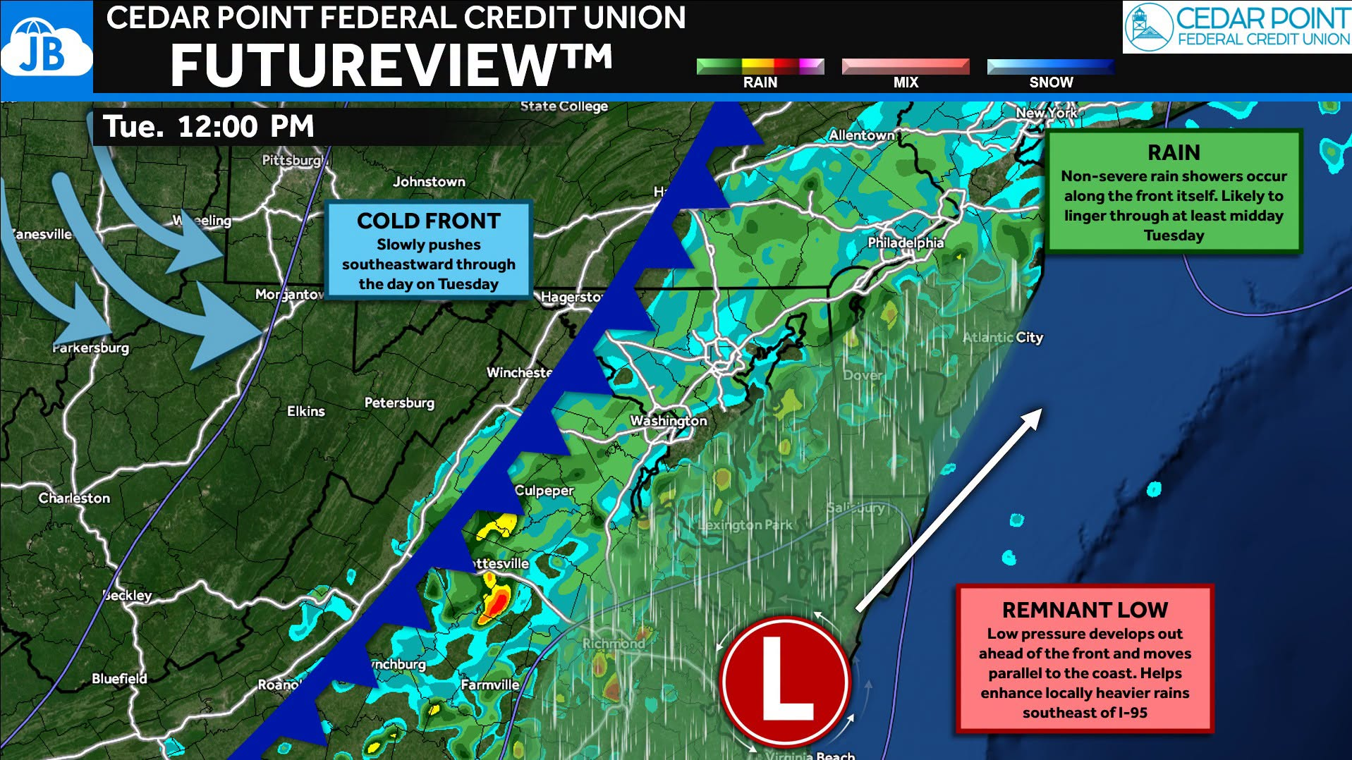
Today’s weather is being driven by a mid-level trough swinging across the Mid-Atlantic while a cold front slowly pushes southeastward through the region.
As the front approaches the coast, a weak area of low pressure is expected to develop near the Virginia Capes and track northeastward. This coastal enhancement is important because it helps focus moisture and lift across Southern Maryland, the lower Delmarva, and Tidewater Virginia.
The atmosphere remains unusually humid for late June, with dewpoints in the 70s and enough instability to support thunderstorms despite extensive cloud cover. Strong winds aloft will also provide sufficient shear for organized bands of storms to develop.
The result is a setup that favors:
- Widespread showers
- Embedded thunderstorms
- Localized heavy rainfall
- Isolated severe weather along the track of the coastal low
Timing: Rain Expands Southeast Through the Day
Based on the latest FutureView guidance, showers become increasingly widespread during the late morning and early afternoon before thunderstorms become embedded within the rain shield.
Morning (7 AM – Noon): Mostly cloudy and humid. Showers gradually expand across the region. Severe weather threat remains low.
Early Afternoon (Noon – 3 PM): Rain becomes widespread. Thunderstorms begin developing within the rain shield. Heavier downpours begin impacting Southern Maryland and portions of the Delmarva.
Mid to Late Afternoon (2 PM – 7 PM): Peak period for impacts. Strongest storms likely across Southern Maryland, lower Delmarva, and Tidewater Virginia. Localized flooding, damaging winds, and an isolated tornado become possible.
Evening (After 7 PM): Activity gradually shifts southeast and offshore. Rain ends from west to east. Conditions slowly improve overnight.
Rainfall Potential
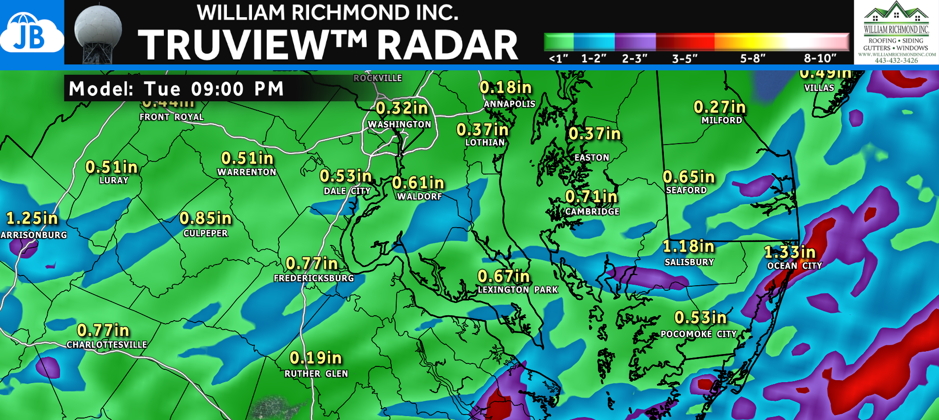
Rainfall amounts will vary significantly depending on where thunderstorms repeatedly develop.
Most locations can expect: 0.25″ to 1.00″ of rainfall. Areas across Southern Maryland, the lower Delmarva, and Tidewater Virginia may see: 1″ to 2″ common totals with 2″ to 4″ localized amounts where storms train
The National Weather Service notes that portions of Calvert and St. Mary’s Counties could experience rainfall rates capable of producing over 3 inches in a relatively short period of time. While widespread flooding is not expected, localized flash flooding could develop in poor drainage areas, low-lying roads, and urban locations.
Severe Weather Potential
Most of the region remains under a Marginal Risk (Level 1 of 5) for severe weather, while portions of southeastern Virginia and coastal areas are under an Elevated Risk (Level 2 of 5).
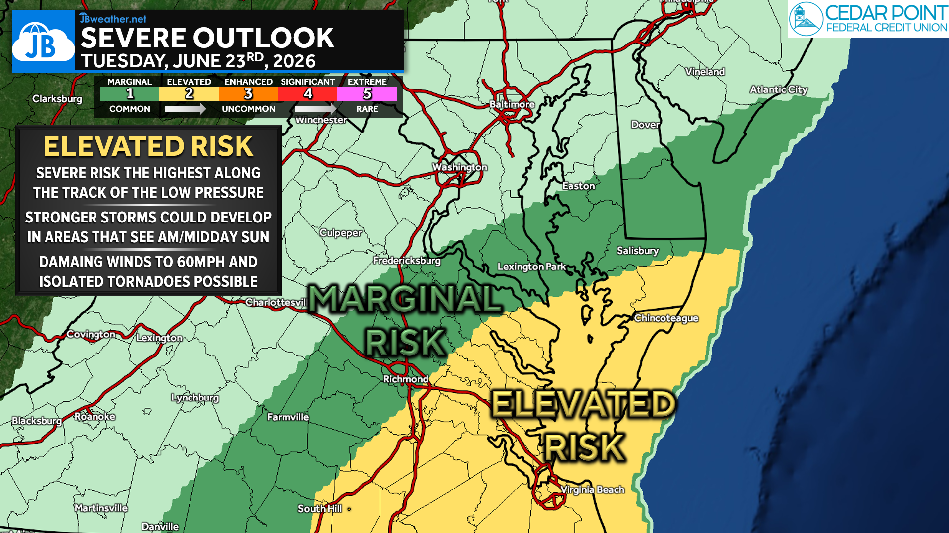
Even though widespread severe weather is not anticipated, a few stronger storms could become organized enough to produce:
Primary Threat
💨 Damaging Wind Gusts: Gusts up to 50-60 mph possible. Capable of downing tree limbs and causing isolated power outages.
Secondary Threat
🌪️ Brief Isolated Tornado: Greatest risk near the coast and along the track of the developing low-pressure system. Enhanced low-level wind shear may allow a few storms to briefly rotate.
The highest severe weather threat appears to be from Southern Maryland southward into the lower Delmarva and Tidewater Virginia between roughly 2 PM and 7 PM.
Bottom Line
Tuesday will be a much cooler but much wetter day across the Mid-Atlantic as a cold front slowly crosses the region.
- 🌧️ Widespread showers and embedded thunderstorms are expected.
- ⛈️ Embedded thunderstorms develop during the afternoon.
- 💨 A few storms may produce damaging wind gusts.
- 🌪️ An isolated tornado cannot be ruled out near the coast.
- 🌡️ Temperatures remain much cooler than Monday, generally in the 70s.
If you have outdoor plans this afternoon, keep an eye on the radar and be prepared for periods of heavy rain and thunderstorms, especially across Southern Maryland and the Delmarva.
Stay with JB Weather for the latest information on impacts here in Southern Maryland and across the Mid-Atlantic. You can always access my forecasts and updates here on the website, on Facebook, on Twitter, on Instagram, and on YouTube. JB Weather is the Mid-Atlantic’s Weather Leader, and I am working around the clock to keep you ahead of any storm!
John Bordash
View More PostsJB Weather forecaster John Bordash is working around the clock to provide Southern Maryland, and neighboring communities, with accurate and reliable weather information.