Brought to you by Dugan, McKissick, Longmore LLC
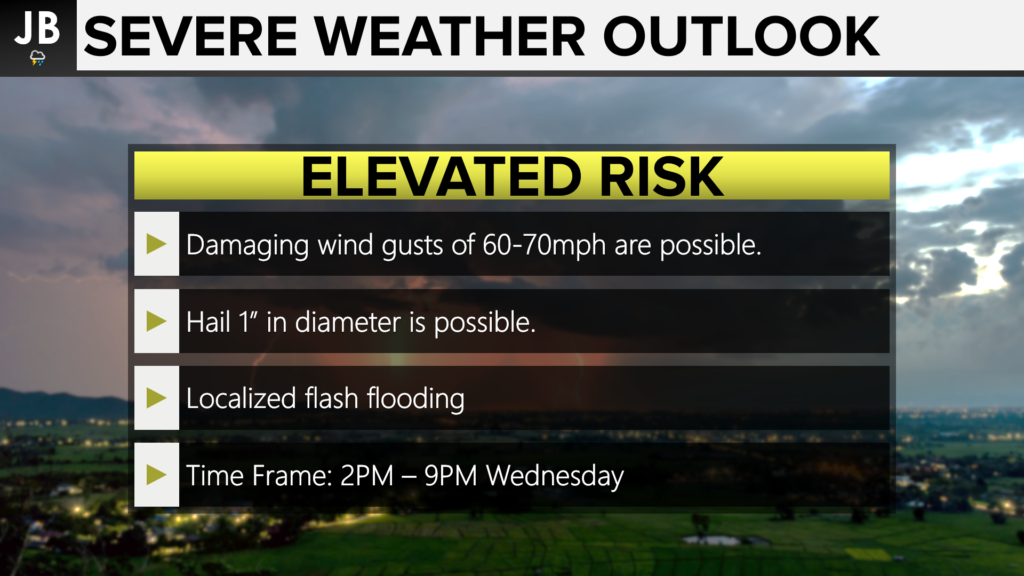
Much of our region has been upgraded to an Elevated Risk of seeing severe weather this afternoon and evening. The main risk today will be the threat of seeing 60-70mph damaging wind gusts and 1-1.5″ hail. We also have a threat of seeing localized flash flooding. The highest threat will be away from the water today, but even coastal locations have a Marginal Risk of seeing a severe storm or two.
Today’s elevated heat and humidity across the Mid-Atlantic are leading to elevated levels of thunderstorm energy, or CAPE levels. An incoming piece of atmospheric energy will swing through our region this afternoon and will look to utilize the elevated CAPE levels. Storms will likely develop across Northern Virginia before the rush hour before trying to move into our region this evening. These storms may weaken some as they move eastward, so it is possible that not everyone will see a storm this afternoon or evening. Our Chesapeake’s Bounty Futurecast does a great job of highlighting all of this.
Stay with JB Weather for the latest information on Southern Maryland weather. You can always access my forecasts and updates here on the website, on Facebook, on Twitter, and on YouTube.
-JB

Dugan, McKissick & Longmore, LLC has served our Southern Maryland community for over 25 years. Our trusted attorneys are here to handle your unique case from beginning to end. To schedule an appointment, call us today at 301-862-3764 or visit our website at www.paxlawyers.com.
John Bordash
View More PostsJB Weather forecaster John Bordash is working around the clock to provide Southern Maryland, and neighboring communities, with accurate and reliable weather information.