Brought to you by Berkshire Hathaway HomeServices McNeils Group Properties
After several days of uncertainty, the forecast for tonight’s winter storm is finally coming into focus. Overnight, much of our model guidance came into agreement, resolving some key differences. It does look like the track of our coastal storm may shift to the west slightly, which would increase local snow totals and impacts. This shift has led to me to revising my forecast some!
Timing

Not too much has changed in regard to our timing with the storm. As we talked about yesterday, it looks likely that we may see some light rain or snow showers develop by lunchtime and into the early afternoon hours. While I am not expecting much accumulation from this initial onset of precipitation, we could see some slick spots for the evening commute. This would be why Prince George’s County Public Schools are releasing students 2-hours early today. I would say that the rest of our school districts have a 50/50 shot at following suit.
The bulk of the snow will come near sunset and move into the overnight hours. The snow is likely to be steady at times, with the heaviest falling in southeastern zones. As the storm pulls out, the snow will gradually end from west to east. Much of the snow should be over by the early afternoon hours.
Accumulation Maps
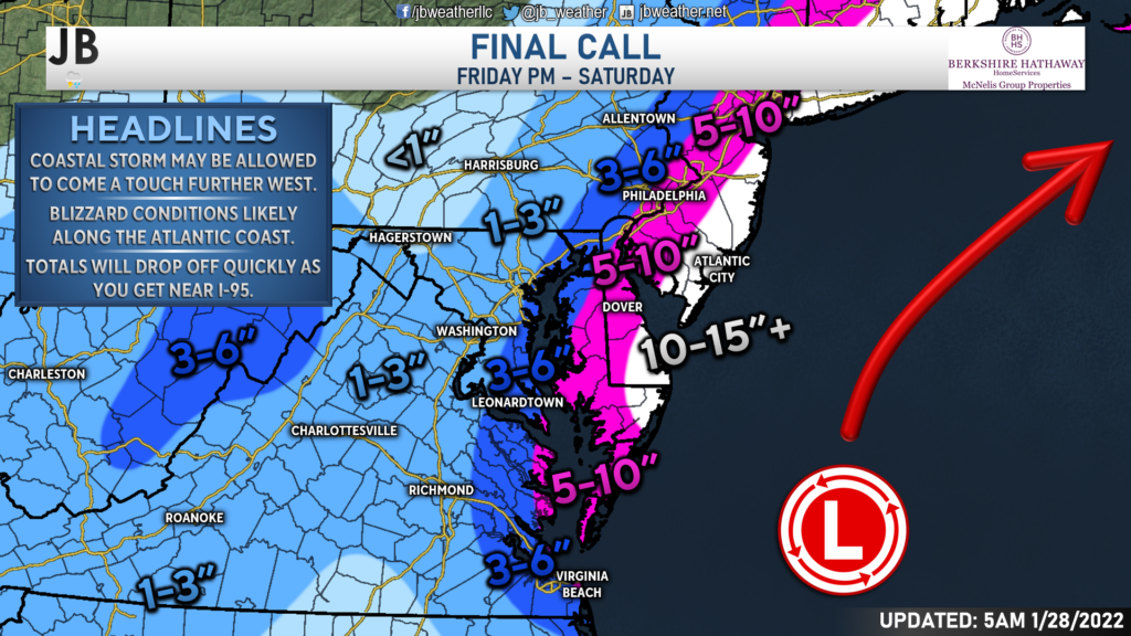
With this slight westward shift, snow totals have been bumped up slightly. I still expect the heaviest snow to fall along the Atlantic beaches, with double-digit snows being likely there. Totals will drop off quickly as you head northwest with this storm, with only an inch or two falling west of I-95. Southern Maryland and the Northern Neck will be sandwiched in between these zones. A matter of 20-30 miles is the difference between a couple of inches and several inches.
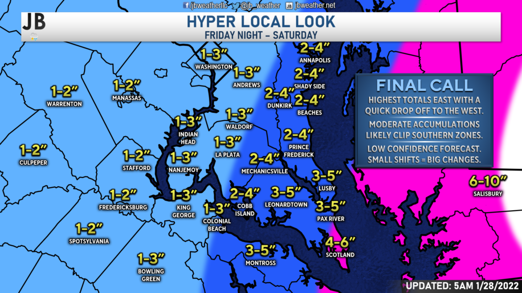
As noted, the heaviest snow will fall in our southeastern zones. I think spots south of Lexington Park, in far southern St. Mary’s County, will receive the most snow– potentially up to 6″. I have placed many areas east of Route-301 in a 3-6″ zone, including most of St. Mary’s, eastern Charles, Calvert, and Westmoreland Counties. Totals will vary quite a bit in this zone as well. I think spots south of Prince Frederick and Mechanicsville have the best shot at seeing 3-5″ while spots northwest of there, up to 301, will likely see 2-4″. Areas west of 301 to I-95 will likely see 1-3″ of snow out of this.
Again, the gradient is tight with this forecast. Not everyone will see over 4″ of snow from this. If you’re north of Prince Frederick or Mechanicsville, I really don’t think you will see more than 4″, with many spots likely seeing less than 3″. It is in southern Calvert, southern St. Mary’s, and Westmoreland Counties where you could see totals up to 5 or 6 inches. Just to be clear, while southern St. Mary’s is shaded in pink, I do not expect them to see up to 10″.
Current Alerts
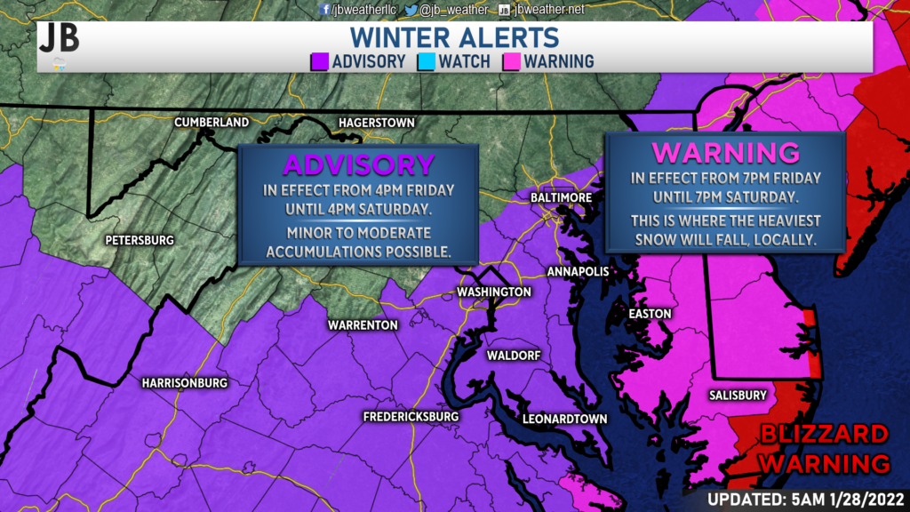
Overnight, much of our region was placed under a Winter Weather Advisory, which is shown in purple. This is where those minor, to potentially moderate, accumulations will fall. Areas to the east are under a Winter Storm Warning, shown in pink. That is where the heavier snow will fall. And take a look at this– the immediate shoreline has been placed a Blizzard Warning, shown in red. This includes Chincoteague, Ocean City, Rehoboth/Bethany Beaches, Cape May, and Atlantic City! This really shows you where those highest totals will be found!
What Coule Go Wrong?
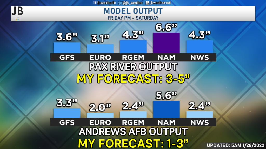
Even with the increased snowfall forecast, my confidence is still low to medium. As you can see above, many of our models have snow totals that are indeed falling within my forecast ranges. With that said, though, a slight shift of just 20-50 miles, either east or west, could lead to less or more snow, respectively. The chance of an additional last-minute shift is totally there. Additionally, we could see dry air get entrenched with this storm, which could lead to dry slots forming and cutting down on totals. I think all these concerns are valid and in play. Do keep in mind that were are likely to see a lot of variance in totals across a small area. What you get in one community may differ from what you see 5 or 10 miles up the road. In light of these plausible scenarios, here’s my assessment of snowfall probabilities:
10% chance: <1″ (Major Bust)
30% chance: 1-3″ (Bust)
40% chance: 3-6″ (Current Forecast)
20% chance: 6-10″+ (Boom)
Summary
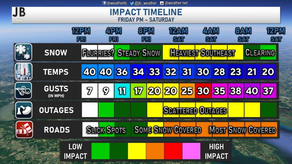
Wow, is this a difficult forecast! The exact track of the low, and a shift of 25-50 miles either west or east, will make all the difference in the forecast. While my totals have increased, I do still think that all possibilities are on the table. With that said, southern and eastern zones will likely see the most, with some spots potentially seeing up to 4 or 6 inches. Totals will drop off quickly northwest of there. With all of that said, I do think that we are likely to see moderate impacts as we head into Saturday. Light snow likely develops this afternoon, with the heaviest falling after sunset tonight. Roads are likely to be snow-covered, and some scattered power outages are yet again possible thanks to gusty winds. Thankfully though, this will not likely be a heavy, wet snow. We will need to monitor how far west the system comes and how strong it gets. Both will play significant roles in determining how much snow does indeed fall and what the impacts could look like. Last-minute shifts could lead to big implications for our forecast.
It will be important to stay with JB Weather for the latest information on this winter storm and its impacts here in Southern Maryland. You can always access my forecasts and updates here on the website, on Facebook, on Twitter, and on YouTube. JB Weather is Southern Maryland’s Weather Leader, and I am working around the clock to keep you ahead of the storm!
-JB

Real Estate now! Not sure where to start? View our Southern Maryland inventory of homes, land, farms and commercial properties on mcnelisgroup.com. Engage with our planning tools to determine your next real estate lifestyle decision, choose your realtor as a trusted advisor. Experience the difference with service and support from real estate’s forever brand!
1 thought on “AM Update: Slight Shift Slightly Increases Snow Totals”
Comments are closed.
Very good report I left Delaware to be with my daughter I miss channEl 6abc now I found you’re report and now I have some one to trust. Thank you