Brought to you by Bill Oosterink, Realtor
This morning, forecast confidence continues to increase for widespread snow, with at least 5 inches likely in many areas, along with icing concerns closer to and southeast of I-95.
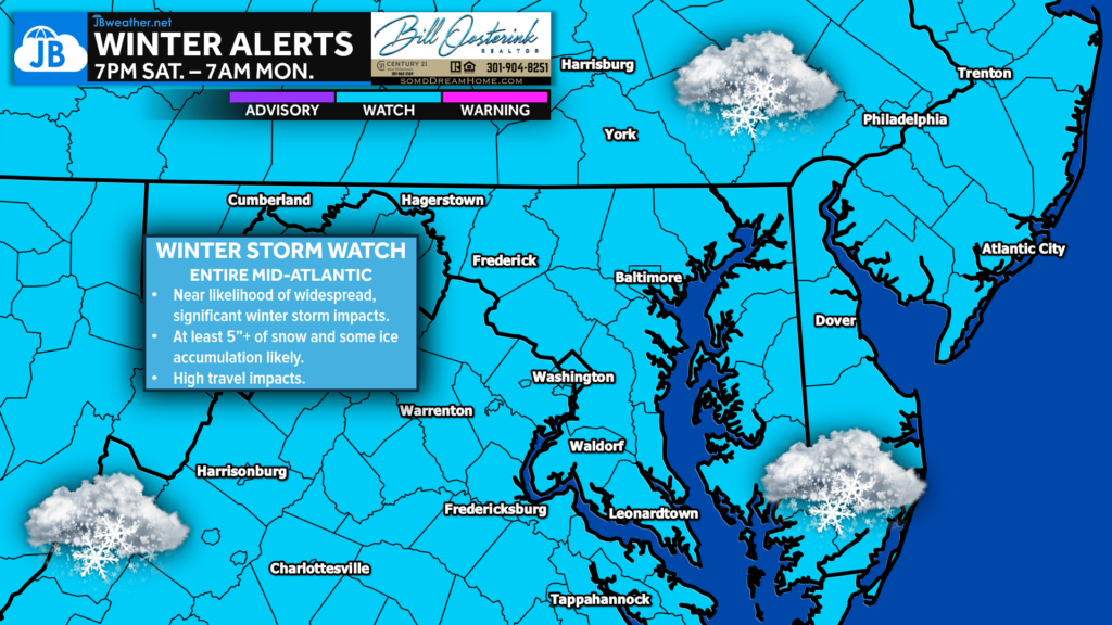
A Winter Storm Watch has been issued for the entire Mid-Atlantic from Saturday evening through Monday morning, signaling a high likelihood of a significant winter storm. Snow may become heavy at times late Saturday night into Sunday, leading to dangerous travel conditions and potential impacts to the Monday morning commute. Very cold air will already be in place, meaning wind chills will be bitter and any snow or ice will linger.
While exact totals and local impacts are still being refined, this is the time to begin preparations and stay weather-aware as we get closer. Above is the recorded videocast from last night!
Stay with JB Weather for the latest information on impacts here in Southern Maryland and across the Mid-Atlantic. You can always access my forecasts and updates here on the website, on Facebook, on Twitter, on Instagram, and on YouTube. JB Weather is the Mid-Atlantic’s Weather Leader, and I am working around the clock to keep you ahead of any storm!
Buying. Selling. Investing. Ready when you’re ready! Check out www.somdDreamHome.com today!
John Bordash
View More PostsJB Weather forecaster John Bordash is working around the clock to provide Southern Maryland, and neighboring communities, with accurate and reliable weather information.
1 thought on “BREAKING: Winter Storm Watch Issued for the Weekend!”
Comments are closed.
You are the best! Thank you so much for your technical passion.