Brought to you by All in One Tag & Title
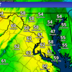
After a cold start to the week, we have seen warmer air finally return to the region. Many spots today have maxed out in the middle to upper 50s, which is still slightly below average for this time of year. However, the push of warmer air will make its presence known by tomorrow as temperatures make a run for the 70s! This will set the stage though for potential storms to develop.

We have a strong southerly flow to thank for our warmer temperatures. This flow will continue into the overnight hours, which will bring some moisture with it. This increase in moisture will allow for scattered rain showers to break out overnight and into early tomorrow morning. These early rain showers should not be a big deal, with the heaviest rains likely staying out towards the mountains. I do not think that we are dealing with severe weather tomorrow morning. With that said, though, the umbrella may not be a bad idea for the morning! We should see a break in the activity by mid-morning.

Behind the showers tomorrow, we will see the winds, which will already be gusty, pick up! We could see our southerly winds gust upwards of 40-50mph at times tomorrow as warmer air surges northward! The worst of the wind is likely to be tomorrow afternoon and evening, as our storms begin to develop.
We will see storms develop out to our west as a strong cold front makes its way eastward. Our southerly winds will help warm us up into the 70s which will help to prime the atmosphere for storm development during the afternoon and evening hours. The more sunshine we see after our morning round of rain will increase the severe threat. Conversely, the less sun we see, the cooler we will stay and the lower the chance of storms will be.
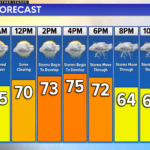
To me, there appears to be two main time frames to watch for storms, which you can see above on our Chesapeake’s Bounty Futurecast. The first would be from 12-5pm from individual cells that may try to develop, which would largely depend on our instability levels. The second would be from 7pm-2am as the cold front passes through, which would likely be a line of storms.

Right now, the Storm Prediction Center has us under a Level 2 “Elevated Risk” of severe weather for tomorrow afternoon. This elevated threat highlights the potential for scattered severe thunderstorms that could produce locally damaging winds, some hail, and potentially even a spin-up tornado. Damaging winds will be the primary threat from any thunderstorms that do develop.
Thankfully, I do not expect this severe weather event to mirror the high-end outbreak that is going on in the Deep South this evening. This does not appear to be a severe weather outbreak situation for our region. With that said, we will need to monitor conditions throughout the day tomorrow to see what happens.
Outside of the severe weather threat, do expect gusty winds throughout the day!
Keep in mind that severe weather forecasting is far from a guarantee of anything. The goal of these forecasts is to alert you to the potential of storms, not a promise of storms. Stay with JB Weather for the latest information on Southern Maryland weather. You can always access my forecasts and updates here on the website, on Facebook, on Twitter, on Instagram, and on YouTube.
-JB

At All In One Tag & Title, we make quick work of MVA Tag & Title Services! We are located in Owings, MD on the corner of Chaneyville Rd. Give us a call at 301-327-5081 or stop by, no appointment needed! Mention you saw us on JB Weather and get $5.00 off tag & title services. Check out www.allinonellc.net today!
John Bordash
View More PostsJB Weather forecaster John Bordash is working around the clock to provide Southern Maryland, and neighboring communities, with accurate and reliable weather information.