Brought to you by RE Graves Heating and Air Conditioning
The tropics have really come to life over the last several weeks. We have seen three systems develop over the last couple of weeks– Fred, Grace, and Henri (pronounced ahn-REE). Fred made landfall in Florida earlier this week and has brought impacts inland across the Eastern third of the nation. Grace is set to make landfall in southern Mexico later on this week. Henri is currently spinning around Bermuda. Many thought that Henri would be the storm that would not affect land, and head out to sea. Recent trends in computer model guidance show that may not be the case though. The National Hurricane Center this after moved include all of southern New England in the forecast cone for Henri as a complex atmospheric setup may steer the storm on a rare track into the coastline.
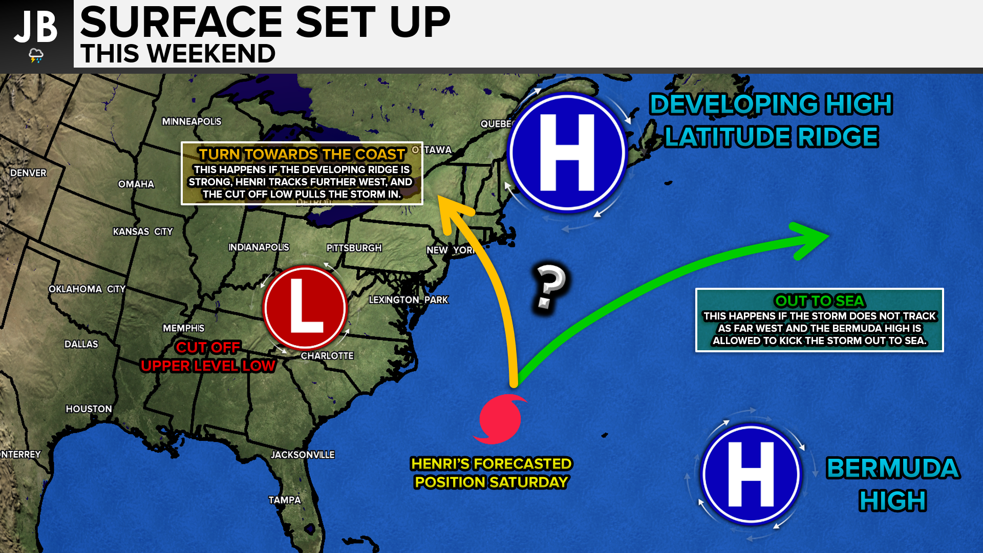
Henri is forecast to continue to moving westward, south of Bermuda, over the next several days. This is thanks to the Bermuda high that has developed and parked itself to the east of the storm. Initial forecasts for the storm assumed that this feature alone would be strong enough to steer the storm out to sea, impacting close to nobody. Over the last 24 hours, our computer models have shown the possibility for the storm to come closer to the coast, or directly into the coast of the Northeast. This would be thanks to a developing blocking ridge in southern Canada that may prevent the storm from going out to sea. This, along with an upper-level low in the Mid-Atlantic, may work in tandem to pull the storm further west and funnel it into the Northeast coastline. Shown below is a graphic that illustrates these threats well.
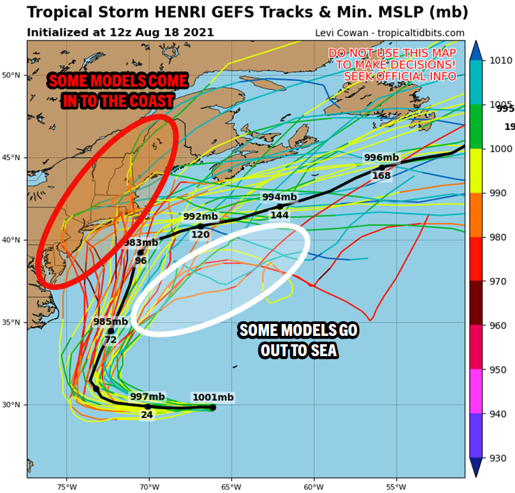
Our computer model guidance, which we rely on to make these forecasts, is not so cut and dry with what will happen. Shown below are the American model ensemble members, which really do showcase the dilemma at hand with many of our other models. Each line represents a model’s track, with the color of the line indicating strength. The brighter and deeper the color, the stronger the storm is on that model. Some models do direct the storm into the coastline and show the storm being quite strong. Other models show the storm being a touch weaker and out to sea. The atmospheric setup does not seem to be supportive of a hit here in the Mid-Atlantic. Given the placement of the cut-off low, the furthest west this storm seems like it could come is northern New Jersey. But we will monitor this as well.
Which solution is right? It’s hard to tell. A growing number of our models are suggesting either a direct hit on southern New England or a glancing blow. While decreasing amount of models keep the storm out to sea, a key model is still on this side– the European. The European has long be regarded as the best tropical model we have, but its performance this season has been subpar. The last time I can remember such a split like this was in 2015 with Hurricane Joaquin. Every model except the European had the developing hurricane making a similar westward bend into the East coast. The European model had the storm going out to sea, and was just about the only one to do so. Sure enough, the European model won in that case as the storm went out to sea. Will the same thing happen here? The European model does not seem to be as skilled as it once was with this kind of setup, but this difference is important to note.
Many of the models generally agree that the storm will reach hurricane intensity over the next few days. Shown below is our hurricane intensity guidance from our models. Each line represents a model’s projected strength of the storm over time. Some models really ramp up the storm to near major hurricane (CAT 3) status, while others keep it at a minimal hurricane. A stronger storm will tend to favor a further west track, and potentially into the coastline.

Summary
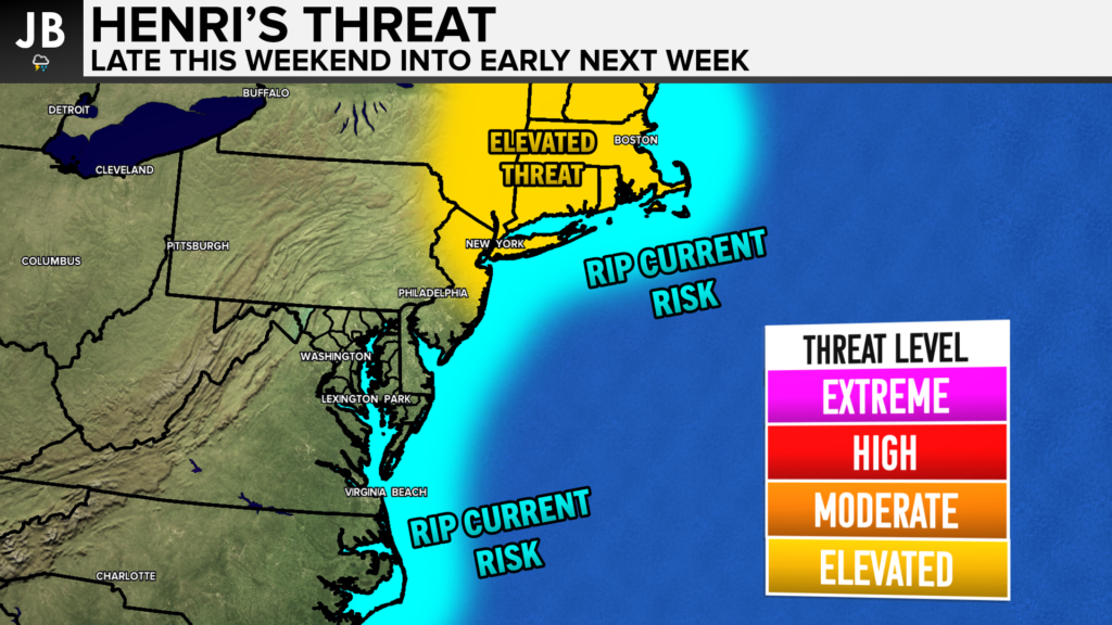
All in all, the forecast with Henri is rather complex and not an easy one to solve. Will the blocking high develop in a way that forces Henri into the coast, or will the storm go out to sea as the European model suggests? We just cannot say definitively at this point what will happen. What we do know is that regardless there is likely to be a high rip current risk this weekend along the East Coast. Interests in southern New England will need to monitor this storm over the coming days. These types of events are very rare, so I will hold making a definitive call on this forecast. It will be important to monitor this forecast over the coming days. A lot can, and will change with this forecast over the next 5 days. At this point, this does not appear to be a direct threat to Southern MD.
It will be important to stay with JB Weather for the latest information on Henri and the potential impacts along the East Coast. You can always access my forecasts and updates here on the website, on Facebook, on Twitter, and on YouTube. JB Weather is Southern Maryland’s Weather Leader, and I am working around the clock to keep you ahead of the storm!
-JB

R.E. Graves Heating & Air Conditioning is a ⭐️⭐️⭐️⭐️⭐️ HVAC Contractor serving St Mary’s & Calvert. Just mention JB Weather to Save 20% off your next Heating repair bill when you Book now! regraveshvac.net/jbweather20off
John Bordash
View More PostsJB Weather forecaster John Bordash is working around the clock to provide Southern Maryland, and neighboring communities, with accurate and reliable weather information.