Brought to you by Cedar Point Federal Credit Union
Our season’s latest winter storm is set to impact the region Tuesday afternoon and evening, with widespread snow likely and moderate to significant accumulations possible. The incoming system has already prompted many districts to close or dismiss early for tomorrow!
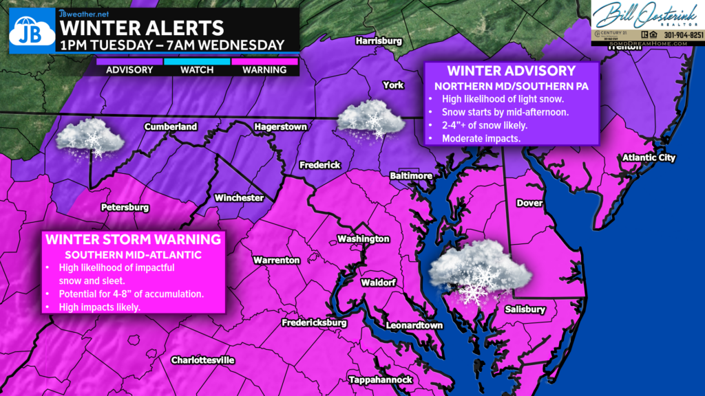
Earlier today, Winter Storm Warnings (pink area) were issued for the DC Metro Area, Southern MD, and Central Virginia for 4-8″ high-impact snow Tuesday afternoon/evening. Winter Weather Advisories were issued for Northern MD and Southern PA for lesser amounts. This highlights where the heaviest snow is likely to be.
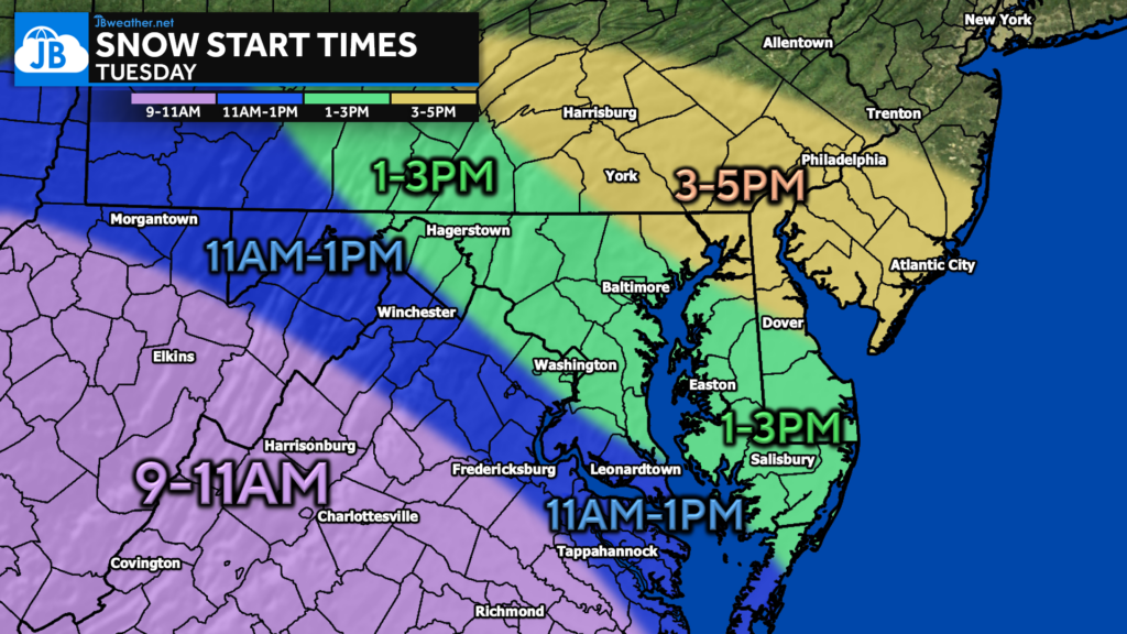
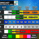
We will likely see light snow overspread the region from southwest to northeast throughout the day. The snow will likely begin during the mid-morning hours across much of Virginia. Snow will begin around lunchtime just south and west of the DC Beltway. 1-3pm looks a reasonable start time across the Baltimore Metro area and the Eastern Shore. 3-5pm as the start time for southern PA, South Jersey, and Philly.
Our Cedar Point Federal Credit Union Futureview model shows snow widespread by 3PM. We can start to see some bands of moderate snow develop by that point around the DC Metro area. These bands will continue into the evening. Southern areas run the risk of seeing sleet mix in off and on throughout the evening, as denoted by the pink shades. We should see the snow shut off by sunrise Wednesday.
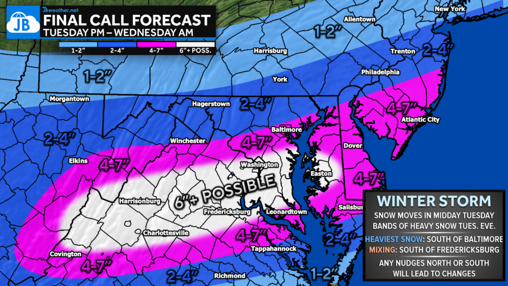
A widespread 4-7″ of snow looks very likely south of Baltimore and north of Tappahannock. This is where periods of heavy snow are likely throughout the afternoon and evening hours. I have highlighted a smaller region within the 4-7″ band that has the best chance of seeing over 6″ of snow, and potentially up to 9″.
Light snow amounts as you head north as the precip rates drop off. Areas from Baltimore to York could squeeze out 2-4″ of snow. 1-2″ north of there. 2-4″ looks possible south of Tappannock, but mixing may cut down on totals there.
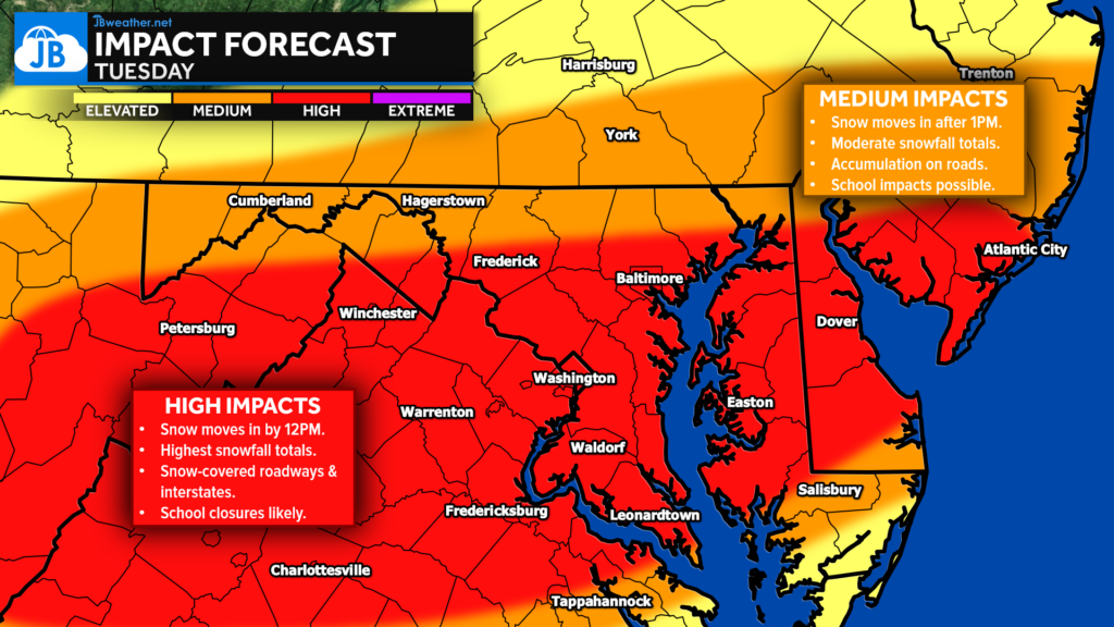
All in all, this looks like a high-impact system for Tuesday. Snow overspreads the region by early afternoon Tuesday, with periods of heavy snow possible by the evening. Mixing will be a concern south of Fredericksburg, Mechanicsville, and Prince Frederick, with some sleet at times. Nevertheless, a solid 4-7″ of snow looks likely with 6-9″ being possible for some as well! Expect these high impacts to linger right into Wednesday.
Stay with JB Weather for the latest information on impacts here in Southern Maryland and across the Mid-Atlantic. You can always access my forecasts and updates here on the website, on Facebook, on Twitter, on Instagram, and on YouTube. JB Weather is the Mid-Atlantic’s Weather Leader, and I am working around the clock to keep you ahead of any storm!
Cedar Point has been providing trusted banking, lending and personal finance solutions to the Southern Maryland Community since 1945. Visit the credit union at any of its 6 locations in St. Mary’s, Charles and Calvert counties or online at www.cpfcu.com.
John Bordash
View More PostsJB Weather forecaster John Bordash is working around the clock to provide Southern Maryland, and neighboring communities, with accurate and reliable weather information.