Brought to you by Chesapeake Orthodontics
A coastal storm will bring our first true wintry weather threat of the season on Tuesday. With marginal cold air in place at sunrise, many areas along and northwest of I-95 may begin as snow before warmer air gradually moves in. As is typical for early December, this system will favor the colder, inland zones.
As precipitation moves in around sunrise, many locations northwest of I-95 should start as snow, while areas southeast of the interstate begin as rain. Through the late morning and early afternoon, slightly warmer air will push the rain–snow line steadily northwest. This will turn snow to a wintry mix for central Maryland and eventually over to all rain by midday near and along I-95. Meanwhile, northern Maryland, southern Pennsylvania, and western Maryland are most likely to remain primarily snow throughout the storm.
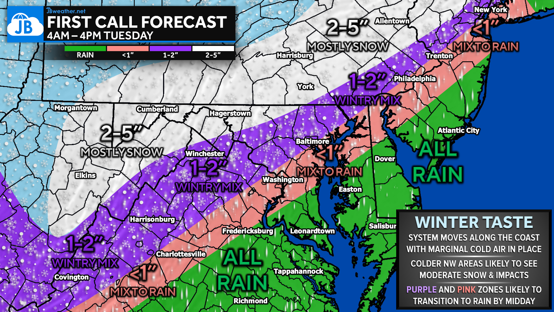
Northern zones that stay mainly snow can expect 2–5 inches, especially across southern Pennsylvania and western Maryland. From the state line down toward I-95, 1–2 inches is more likely before mixing and rain cut totals. Along the I-95 corridor itself, any early flakes should be brief with little to no meaningful accumulation, while areas southeast of I-95 should expect an all-rain event from start to finish.
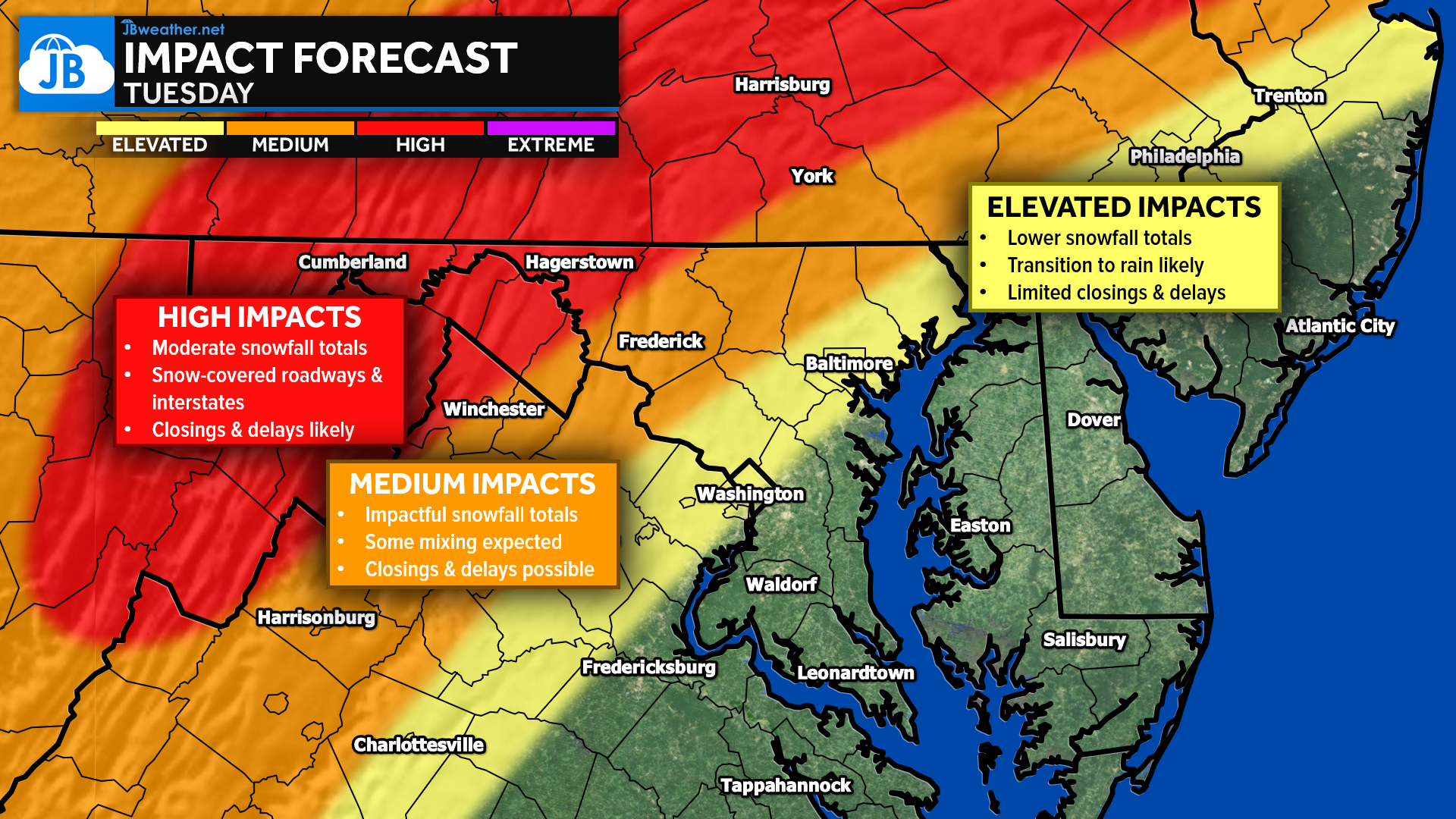
The early timing means the morning commute could be impacted across colder northwest regions, with slick roads and reduced visibility possible. School or business delays and closures are possible north and west of I-95, especially closer to the Pennsylvania line, though it is still a bit early for specific school-odds forecasts. Travel impacts will be far lower near and southeast of the major cities where rain quickly becomes dominant.
Frequently Asked Questions
• Who is most likely to see accumulating snow?
Areas northwest of I-95 in northern Maryland, southern Pennsylvania, and western Maryland have the best shot at meaningful accumulation. These zones fall in the 1–2″ to 2–5″ ranges.
• Will the I-95 corridor see any impacts?
Only minimal ones. Snow may start the day, but warm air quickly changes everything to rain, limiting accumulation and reducing travel issues.
• What about southern Maryland and the Eastern Shore?
These locations are in the all-rain zone with no wintry accumulation expected.
• When will roads be most slippery?
Between sunrise and late morning in the colder northwest zones, where snow will be falling before temperatures rise enough to mix with or change to rain.
• Are school delays or closures possible?
Yes, north and west of I-95, especially near the Pennsylvania line. It’s still early for exact school-odds forecasts, but the setup supports potential delays where the heaviest early snow falls.
• Is this a major storm?
No. This is a fairly typical early-season system with marginal cold air. It will bring impacts, but mainly confined to colder inland regions.
Stay with JB Weather for the latest information on impacts here in Southern Maryland and across the Mid-Atlantic. You can always access my forecasts and updates here on the website, on Facebook, on Twitter, on Instagram, and on YouTube. JB Weather is the Mid-Atlantic’s Weather Leader, and I am working around the clock to keep you ahead of any storm!
Dr. Thomas Hao and Dr. Dylan Schneider offer comprehensive orthodontic services for all ages. Schedule your free consultation today. Visit www.SOMDBraces.com today for more information!
John Bordash
View More PostsJB Weather forecaster John Bordash is working around the clock to provide Southern Maryland, and neighboring communities, with accurate and reliable weather information.