Brought to you by Chesapeake Orthodontics
As we enter the new year, many of our snow-starved followers wonder if Winter will ever show up for the Mid-Atlantic. We have been amid another 2-year snow drought, and we are coming off of a balmy December featuring almost no snow and temperatures nearly 4° above average. I do see some hope for snow lovers as our overall weather pattern begins to change. And, for the first time in nearly 2 years, the JB Weather Winter Index has nudged up!
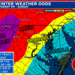
I upgraded our Winter Index to a “Level 2” early Monday morning. This shows that we are currently monitoring and watching for the potential for winter weather over the next 7 days. While this does not guarantee snow, it does denote that the potential does exist for winter weather as our pattern flips. So, what has caused this change?
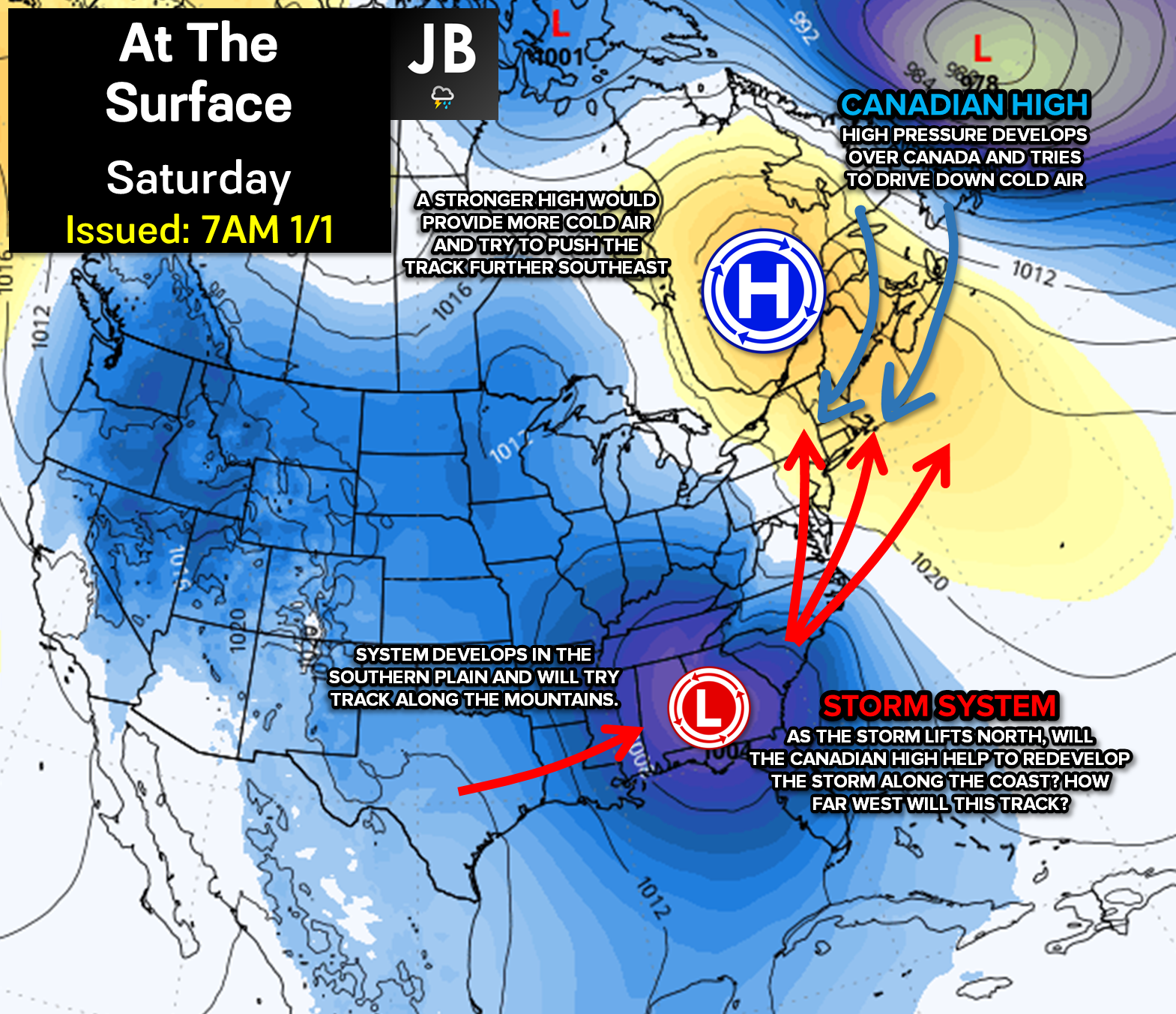
To make a technical story short, we will see a fresh injection of cold air this weekend as an area of high pressure sets up to the north. At the same time, we will see a storm system begin to take shape in the southern Plains. As this storm progresses along the spine of the Appalachians, it will run into this high pressure. This interaction will likely force the storm to redevelop along the coast.
A storm developing along the coast with a cold-air dominant high to the north might sound promising for the month of January! And indeed, it is. However, the biggest outstanding question is where exactly this track will be. Will this storm take a track along the I-95 corridor, bringing cold rain to many areas, or will this track just off the coast, allowing for winter weather? It is too early to say, and I could make a case for both scenarios.
There is a lot of uncertainty with this forecast– which makes sense. We’re still 5-6 days out from this system potentially affecting us. It will be hard to say for sure what will happen until we get more answers on this system and the atmospheric drivers around it. Snow lovers, I would calm down your excitement! There is no certainty at this point what we could see locally. All scenarios are still in play.
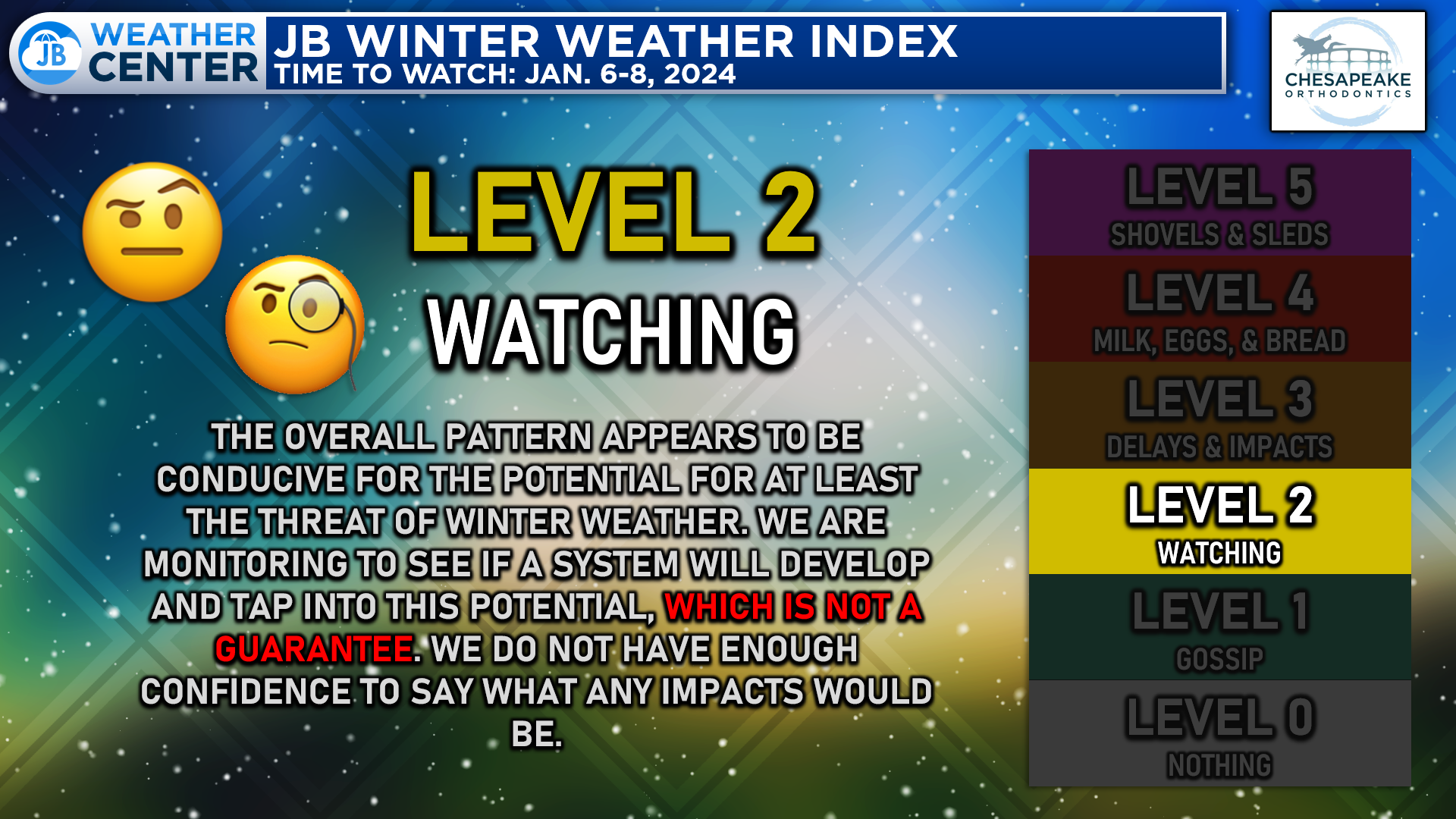
As things stand now, I will place us on a Level 2 on the Snow Index. Sure, the pattern looks favorable for a potential winter storm. However, there is a lot of uncertainty with this forecast– which makes sense. We’re still 5-6 days from this system potentially affecting us. It will be hard to say for sure what will happen until we get more answers on this system and the atmospheric drivers around it. More answers will begin to show themselves as we approach midweek. For now, disregard any hype you may see.
Stay with JB Weather for the latest information on impacts here in Southern Maryland. You can always access my forecasts and updates here on the website, on Facebook, on Twitter, and on YouTube. JB Weather is Southern Maryland’s Weather Leader, and I am working around the clock to keep you ahead of any storm!
-JB
Dr. Thomas Hao and Dr. Dylan Schneider offer comprehensive orthodontic services for all ages. Schedule your free consultation today. Visit www.SOMDBraces.com today for more information!
John Bordash
View More PostsJB Weather forecaster John Bordash is working around the clock to provide Southern Maryland, and neighboring communities, with accurate and reliable weather information.