Brought to you by SouthernMaryland SportsCards
Our recent streak of humid days across the region will look to come to end, even if it’s only briefly. Showers and thunderstorms will look to develop across the region late tonight and linger into Saturday. Hit-and-miss pockets of heavy rain will be possible and could lead to localized areas of flooding.
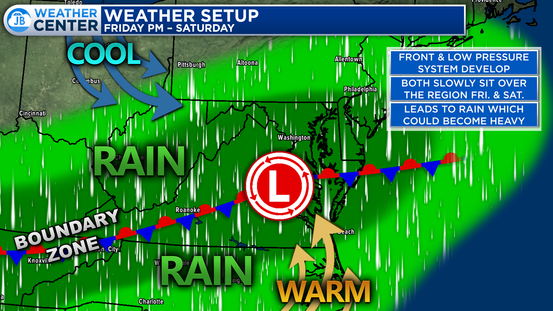
This rain chance will be thanks to a stationary frontal boundary and a slow-moving area of low pressure. These will both gradually work their way off the coast this weekend. However, these two will lead to rain developing across the Mid-Atlantic. We will see that rain focus along the boundary zone that will separate cooler and warmer air. The stark contrast in temperature on either side would help to create the potential for pockets of heavier rain to develop.
Our Chesapeake’s Bounty Futurecast shows that we are likely to see the rain begin to develop across the region as we approach sunset tonight. The area of the heaviest rain will likely be focused northwest of I-95 overnight. Futurecast shows that as we head into tomorrow, the heavy rain threat shifts eastward.
This specific model depicts some of the heaviest rains setting up across Southern MD tomorrow. While it is possible, it is not a guarantee. All of our model guidance agrees that there will be a zone of heavy rain somewhere in the Mid-Atlantic. However, they all diverge somewhat on the exact placement.
The duration of the rain is likely to depend on how quickly the area of low pressure gets out of here. It is possible that it slides out to sea pretty quickly. This would allow for the rain to end during the early afternoon. It is also possible that the low is slow to move out. That would allow the rain to drag on through the evening.
It is important to note that it will not rain everywhere all day. While the chance of seeing rain is widespread, there will be holes in the coverage of the rain. This may mean that some spots see very little rain over the next 24-36 hours while others see quite a bit. It is very difficult to pinpoint exactly where those pockets of heavy rain and little rain will set up.
One of my friends, Tim Buckley (a meteorologist in North Carolina) created this diagram to demonstrate some of the reasoning and complexity of forecasting summertime thunderstorms. When you boil water in a pot, you know that there will be bubbles that race to the top. However, you don’t know where the bubbles will happen. This is because the exact spot of development is rather random in nature.
The same sentiment used in this example is what will drive our forecast tomorrow. We know that there will be pockets of heavier rain tonight and tomorrow. And, we have a general idea of where it may happen– the Mid-Atlantic. However, it is near impossible to pinpoint where exactly the heaviest bands will set up.
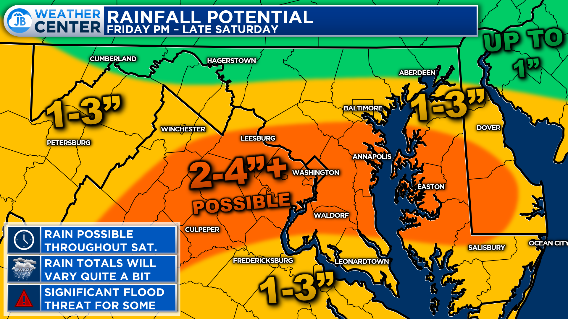
Buy and large, it looks like 1-4″ of rain will be possible across the region over the next 24-36 hours. For the reasons mentioned above, it is nearly impossible to draw an exact rainfall map that pinpoints who the big winner and losers will be. Some will see less than half an inch of rain tomorrow, even in the orange zone, and some will see more than 4″. So, this is just a general look at what may happen.
I have tweaked some things on the rainfall potential map for tonight & tomorrow. Our latest guidance suggests that the heaviest rains over the next 24-36 hours may set up between Baltimore & Fredericksburg. As much as 2-4″ certainly looks possible, with localized higher totals. “Locally higher” means that there are likely to be a few towns that see more than 4″, but not enough to warrant me drawing a new forecast range because it is likely to be limited who sees those highest totals.
As you may have gathered, forecasting summertime rainfall amounts is very different and much more complex than forecasting winter snowfall totals. Snow totals tend to be more uniform, and are easier to draw on a map with a higher degree of accuracy. Summertime rainfall can vary so much over such a short distance, that it is nearly impossible to capture every small bit of nuanced. This is the downfall of using “rainfall forecast maps” as we do snowfall maps. However, I wanted to give you an idea of what seems the most possible.
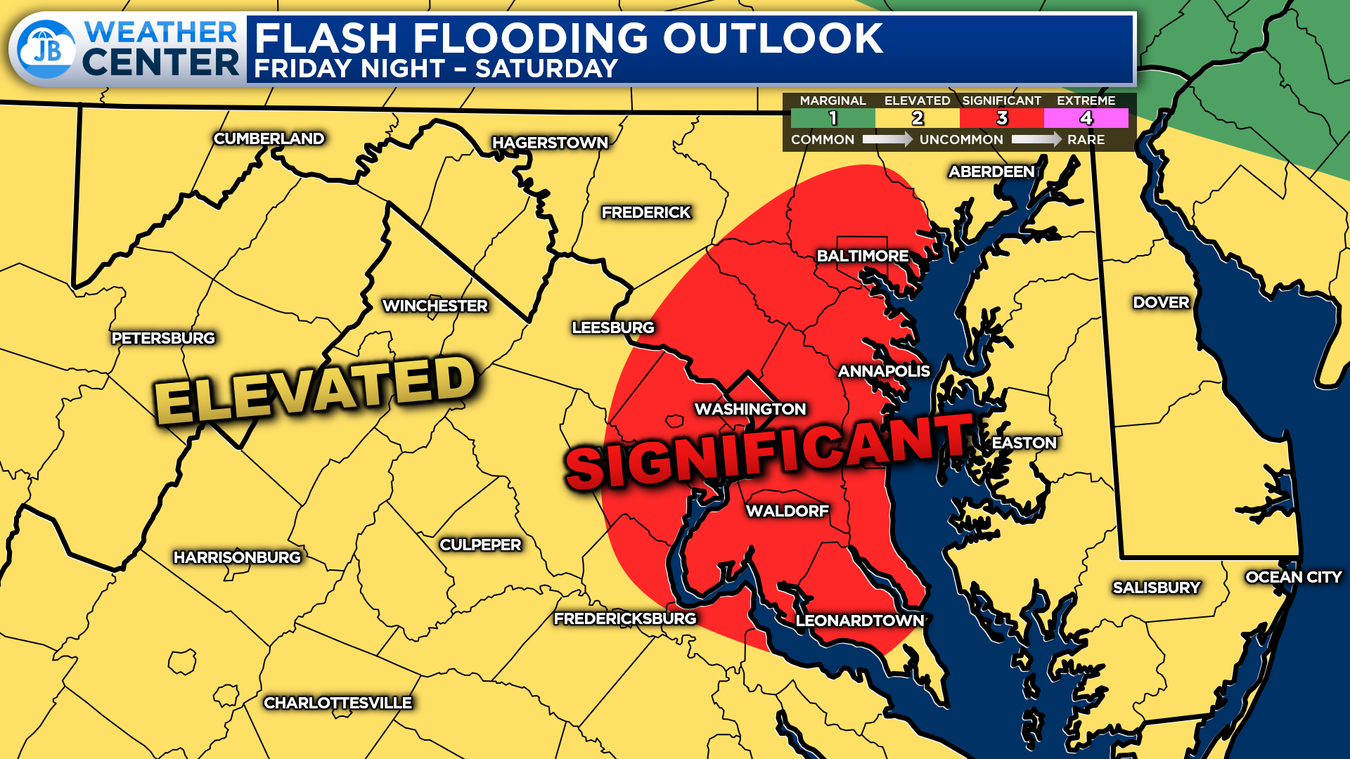
The Weather Prediction Center has highlighted just about our region under a Level 3 “Significant Risk” of flash flooding over the next 24-36. The highest chances tonight will be west of I-95 with the highest chances on Saturday being east of I-95.
These threat categories are different than severe weather threat categories where we only have 4 risk levels here, as opposed to 5 with severe weather. This means that a Level 3 flooding risk is far more serious than a Level 3 severe risk. A level 3 flooding risk means that areas of heavy rain are likely and that numerous areas of flooding are very possible, if not likely. This Level 3 flood risks get issued only a couple of times a year in our region.
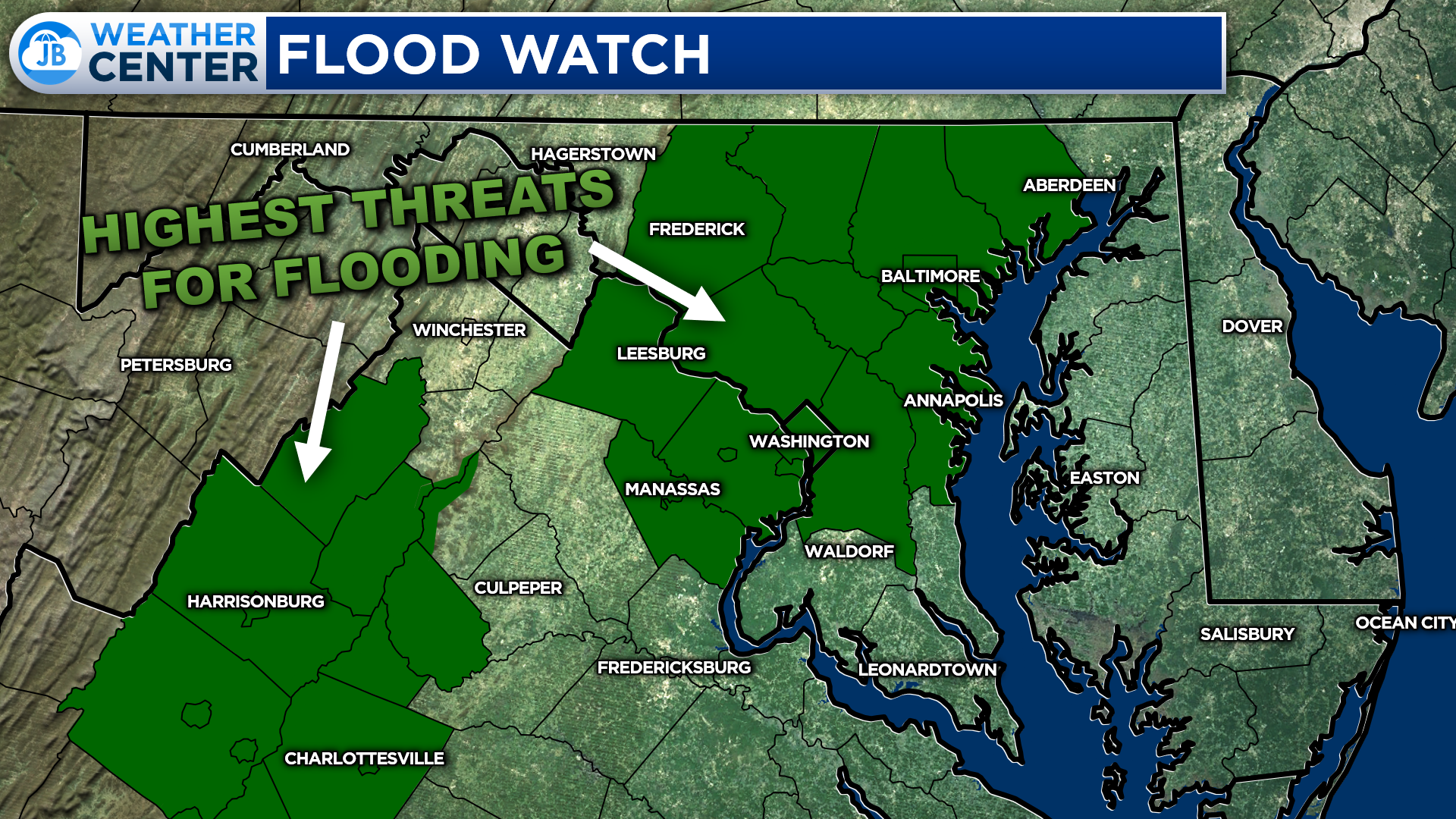
The National Weather Service has already issued Flood Watches, shown in dark green, for the areas they believe are most at risk of seeing flooding. These areas are in northern/central Maryland, the DC metro area, and the highlands of Virginia. These watches run from 11pm tonight through 2pm Saturday.
I believe that much of the region has a similar flooding risk, across the board. But, again, pinpointing where these heavy rain bands will set up is quite difficult. I would not be surprised to see this Flood Watch get reconfigured as we move forward, to better capture the threat zone as we learn more.
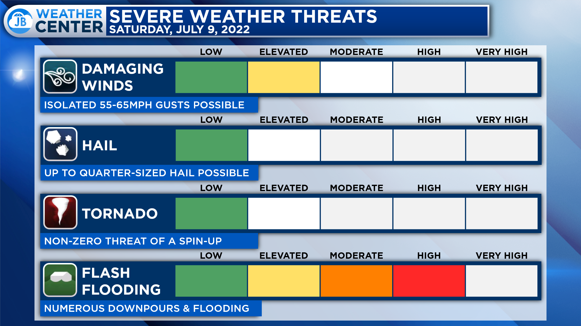
All in all, the next 24-36 will have the potential to bring moderate to high impacts. Pockets of heavy rain will likely develop, thanks to a slow-moving frontal boundary and storm system. The main risk tomorrow will come from Flash Flooding. Some areas picking up as much as 1-2″+ of rain. We may also see some embedded thunderstorms develop tomorrow. The severe risk is low tomorrow, but we could see 1 or 2 storms contain 55-65mph wind gusts.

It will be important to stay weather aware tonight and tomorrow, especially if you are traveling. Not everyone will see heavy rain and flooding tomorrow. However, those that do could see high impacts develop quite quickly. Outdoor activities are going to be rather difficult to pull off tomorrow given the complex forecast, and the high ceiling of the rain potential.
Stay with JB Weather for the latest information on Southern Maryland weather. You can always access my forecasts and updates here on the website, on Facebook, on Twitter, on Instagram, and on YouTube.
-JB

Southern Maryland born and raised, Matt buys sports card collections for cash. Connect with him on Facebook, email at [email protected], or meet him at the Southern MD Sports Card Show, before and during the Southern MD Blue Crabs game, on August 20th! Check out
https://www.facebook.com/southernmarylandsportscards
John Bordash
View More PostsJB Weather forecaster John Bordash is working around the clock to provide Southern Maryland, and neighboring communities, with accurate and reliable weather information.