Brought to you by Berkshire Hathaway HomeServices McNeils Group Properties
Our first snow of the season yesterday ended up being our biggest winter storm since the Blizzard of 2016, which was just about 6 years ago! Our northern zones saw 10-15″+ of snow, with the highest total being reported in Huntingtown at 15.5″. Our southern zones also saw impressive snow amounts, with many zones seeing 6-10″; the most down there in nearly 3 years. In the aftermath, many were left in the dark with several people stuck on area roads for hours. While many people may be over the snow, we have more snow on the way to close out the week.
Barely into the clean-up stage, and before snow lovers can even come down off their winter storm high, we’ve got another winter storm to track. A system is expected to move through late Thursday night into Friday and has the potential to once again bring us either a pure snow or a snow/sleet mix.

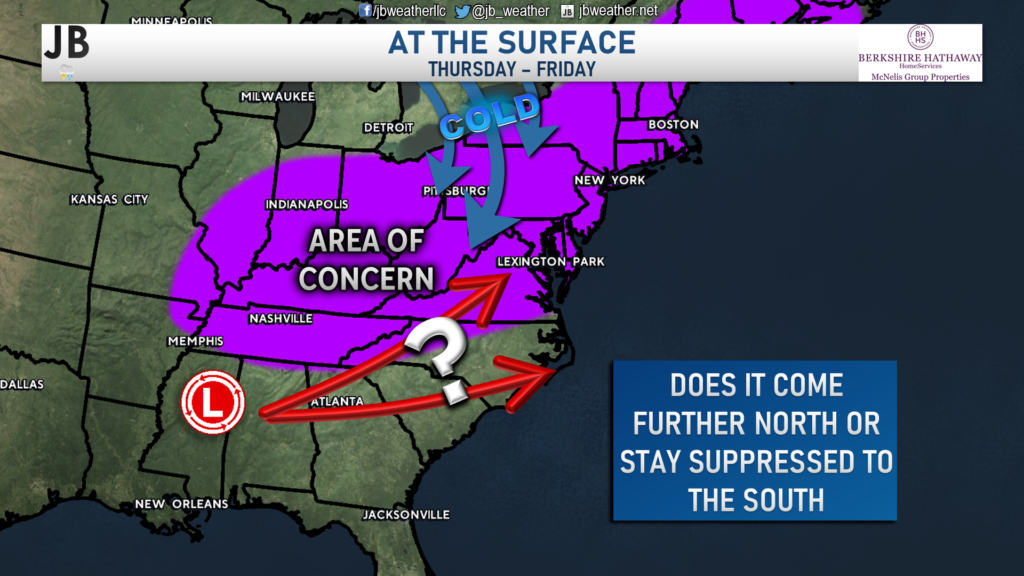
The storm that has eyes on the area will develop in the Mid-South during the middle of the week. The storm will head towards the coast so that by late Thursday night the storm’s low-pressure center should be getting close to the region. The biggest question that we have right now is: How far north will the storm track?
Right now, precipitation from this system would probably begin after midnight on Friday and could be a mix of precip at first. If the storm track stays suppressed, then that mix could over to snow. However, if the storm comes further northward, we may stay as a mix. As is typically the case, the exact track will determine who gets snow or a mix and how much. This storm looks to move out of the region by midday Friday. Shown below are the two scenarios we could see with this storm:
Scenario 1: Southern Track

Likelihood: 60% chance of happening
Overview: A fresh injection of cold air that will be moving in around the same time would be strong enough to push the storm track further south.
What We Would See: The southern track would help to transition any mix over to a pure snow. The mix zone would be held down to the south of our region. This could allow for light to moderate snow accumulations.
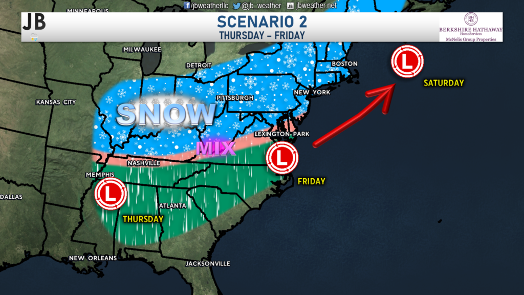
Scenario 2: Northern Track

Likelihood: 40% chance of happening
Overview: A fresh injection of cold air that will be moving in around the same time would not be as strong enough, and could allow the storm to track further north.
What We Would See: The northern track would prevent how cold we could be during the event. This would likely place the area of snow to the north, with a snow/sleet/rain mix south of DC.
As with any storm more than 48 hours away, any snow accumulation estimates are iffy at best. Impacts are likely on Friday morning regardless of the track. Granted, impacts would likely be higher with a southern and more snowy track. With that said, this storm does not look like it would bring Southern Maryland nearly as much snow as Monday’s event did. Right now, I do favor a more southern solution with this storm threat. The high pressure that would be supplying the fresh injection of cold air looks to be strong, which should keep the storm further south. However, I will not totally write off a more northern track just yet. We are still ~72 hours out, and a lot can change.
We will know more details about this threat as the week goes on. I have high confidence that we will see a storm move through on Friday. The confidence begins to drop a tad when figuring out where exactly the storm will track, and subsequently, what type & how much precipitation we will see. I typically do not issue accumulation maps more than 48 hours in advance of a system, which would mean that a First Call forecast would likely come tomorrow.
Stay with JB Weather for the latest information on impacts here in Southern Maryland. You can always access my forecasts and updates here on the website, on Facebook, on Twitter, and on YouTube. JB Weather is Southern Maryland’s Weather Leader, and I am working around the clock to keep you ahead of any storm!
-JB

Real Estate now! Not sure where to start? View our Southern Maryland inventory of homes, land, farms and commercial properties on mcnelisgroup.com. Engage with our planning tools to determine your next real estate lifestyle decision, choose your realtor as a trusted advisor. Experience the difference with service and support from real estate’s forever brand!

