Brought to you by Daisy May Boutique
After a chilly weekend, the threat for some light freezing drizzle may be in the cards for some early Monday morning. A weak storm system will be passing off the coast overnight tonight and will look to throw moisture back towards the coast. With enough cold air in place, this could lead to that light freezing drizzle. With that said, though, this does not look to be a widespread or highly-impactful event.

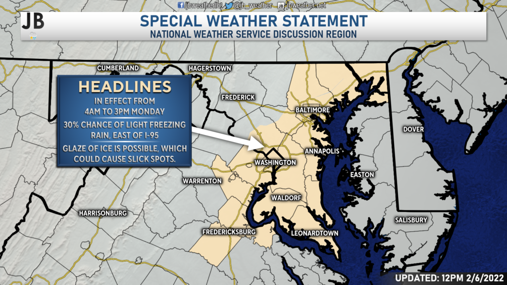
The National Weather Service has already gone ahead and issued a Special Weather Statement for the counties shaded in tan for tomorrow morning. This includes many counties along and east of I-95. These will be the zones with the highest chances, around 30%, of seeing the light freezing rain.
As the system slides off the coast tonight, we will see an increase in moisture. With enough moisture present, we may see some patchy freezing drizzle develop east of I-95. Above, I have a clip of Futurecast simulated radar through noon on Monday. This model is one of the only ones to show the freezing rain being somewhat widespread. Many of our other models show very limited precip across the region. This leads me to believe that any freezing drizzle will likely only be isolated to scattered in nature.
As mentioned previously, there is only a 30% chance that your specific location will see freezing rain. It is very possible that you see almost nothing tomorrow morning.

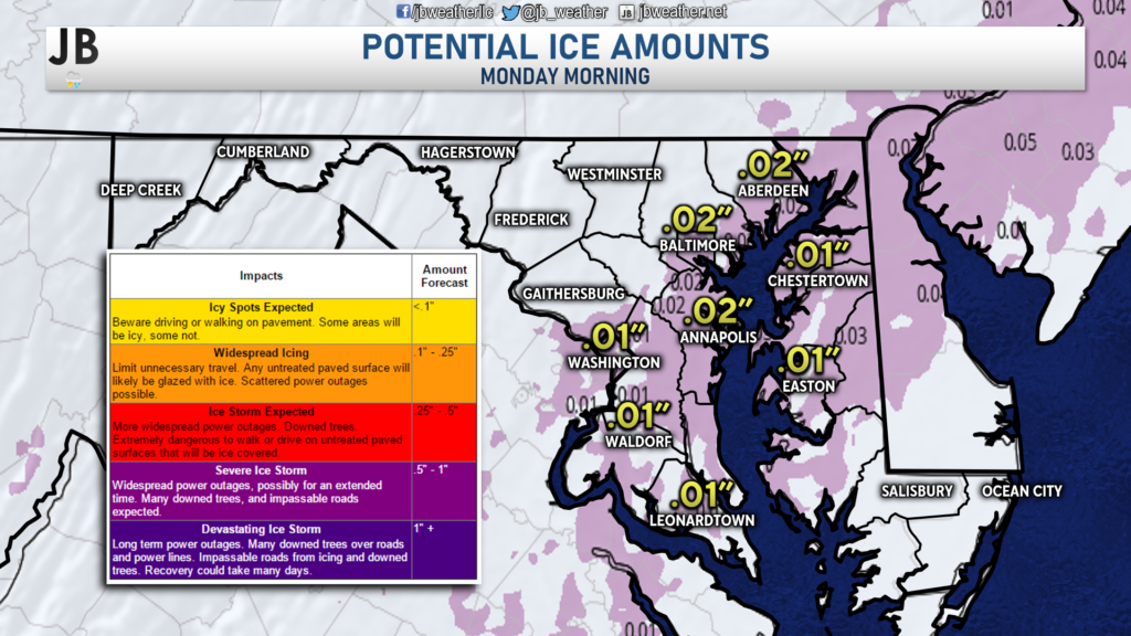
If we do indeed see freezing rain develop tomorrow morning, it is not likely to be widespread or impactful. The current National Weather Service forecast is for a couple of hundredths of an inch of ice accumulation, at most. This does not look to be an ice storm or an event that will lead to widespread power outages. At most, this could be an event that causes some slick spots on secondary roads.
After lunchtime tomorrow, with warming temperatures, it is possible that we see a zone of plain rain move through the region. Shown above is a separate clip of Futurecast depicting this threat. It is possible tomorrow afternoon that we see some heavier pockets of rain develop. Again, this is not a sure thing. With that said, I would be aware of the potential of scattered pockets of moderate to heavy rain moving through tomorrow afternoon, regardless of the morning ice threat.

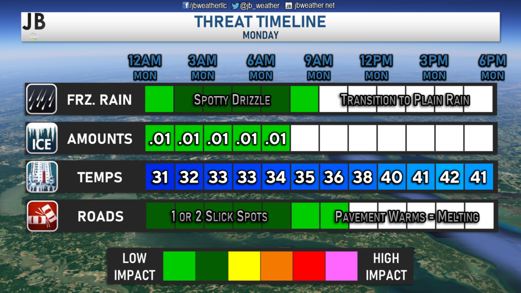
The timing for spotty freezing drizzle would likely be from midnight to 7am Monday morning. Again, I do not expect widespread freezing rain. I think it is very possible that many people seeing almost nothing tomorrow morning. However, those that do see some freezing drizzle could see slick spots develop. I do not expect this to have a high impact on the morning commute, thanks to how limited the freezing rain will be in nature. However, we could see some slick spots develop, primarily on secondary roads. As things stand now, I would only give local school systems about a 30% chance to delay. Temperatures will warm throughout the morning, which will help to melt away any ice accumulation. Additionally, the warming temps will allow any freezing rain to transition to plain rain by mid-morning.
This event does not look like something you should be overly worried about. However, I do think that this is something you will want to monitor. Check-in with JB Weather tomorrow morning before heading out, to see what is going on and what to expect.
Stay with JB Weather for the latest information on this potential event and its impacts here in Southern Maryland. You can always access my forecasts and updates here on the website, on Facebook, on Twitter, and on YouTube. JB Weather is Southern Maryland’s Weather Leader, and I am working around the clock to keep you ahead of the storm!
-JB

Daisy May Boutique is a womens boutique local here in St. Mary’s county. We are predominately online but have open houses and private shopping experiences often. Be sure to check us out on Facebook for upcoming open house dates and shop us online at www.daisymayclothing.com
2 thoughts on “Forecast: Patchy Freezing Drizzle Possible Monday AM”
Comments are closed.


When we’re looking at the future cast, why does it look like the precipitation pops up and swells and then disappears?and continues to do that over and over? Is this really what happens?
Good morning, Nicole! Your eyes are not deceiving you– that is indeed what happens with some of our Futurecast models. This normally happens because some of our models, like the one used here, actually only have radar frames for every two or three hours. That’s to say, this model will have a depiction of radar for 8am and 10am, but not its own frame for 9am. What our system does to composite that, and to produce an animation, is that it will pulse down the precip in between 8am and 10am, causing the bubbling animation. Thankfully, this only happens with a select few of our models!