Brought to you by Chesapeake Orthodontics
After a stormy evening last night, many areas have been allowed to dry out today. However, we will see a southern system push northward and bring our region additional rainfall throughout tonight and into Tuesday.
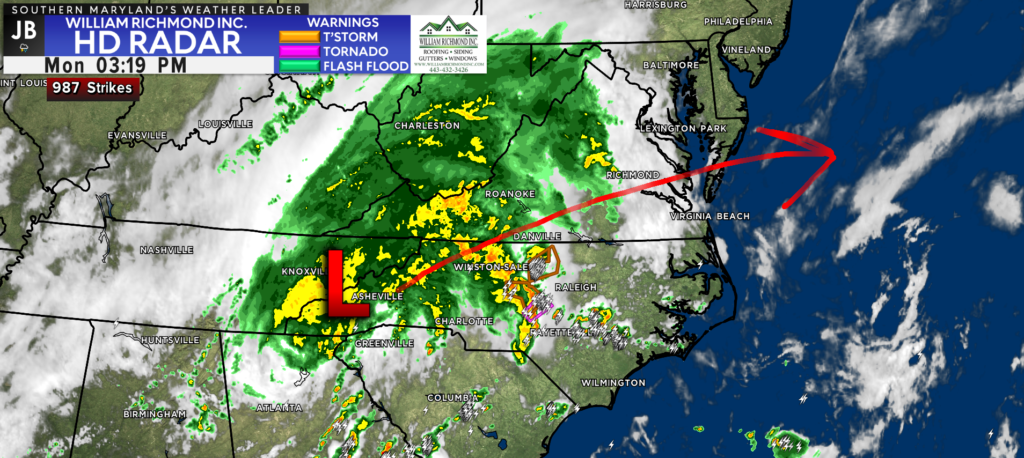
This afternoon, you can clearly see where our system is on the satellite and radar imagery. This system was a non-tropical disturbance that pushed onshore of the Gulf Coast late yesterday. This system has continued its northward progression, working through the Southeast. We will see this north/northeastward track continue through Tuesday before the system stalls off the coastline and eventually dies out.
We will see the bulk of the rain with this system overnight tonight. The heaviest rains will be focused across Virginia, with a gradual drop off in the rain as your approach the Mason Dixon Line. Rain will push into our region during the evening rush hour.
After sunset, we may see steady to moderate rain bands develop across portions of our region. We should see the rain begin to break up some after sunrise tomorrow. However, our model wants to keep the chance of scattered showers around throughout the day tomorrow. It is unclear how widespread or heavy tomorrow’s rain showers will be. I would expect hit-and-miss showers throughout the day, but we may see a couple of pockets of sustained rain develop south of DC. I would definitely have the umbrella ready to go for tomorrow.
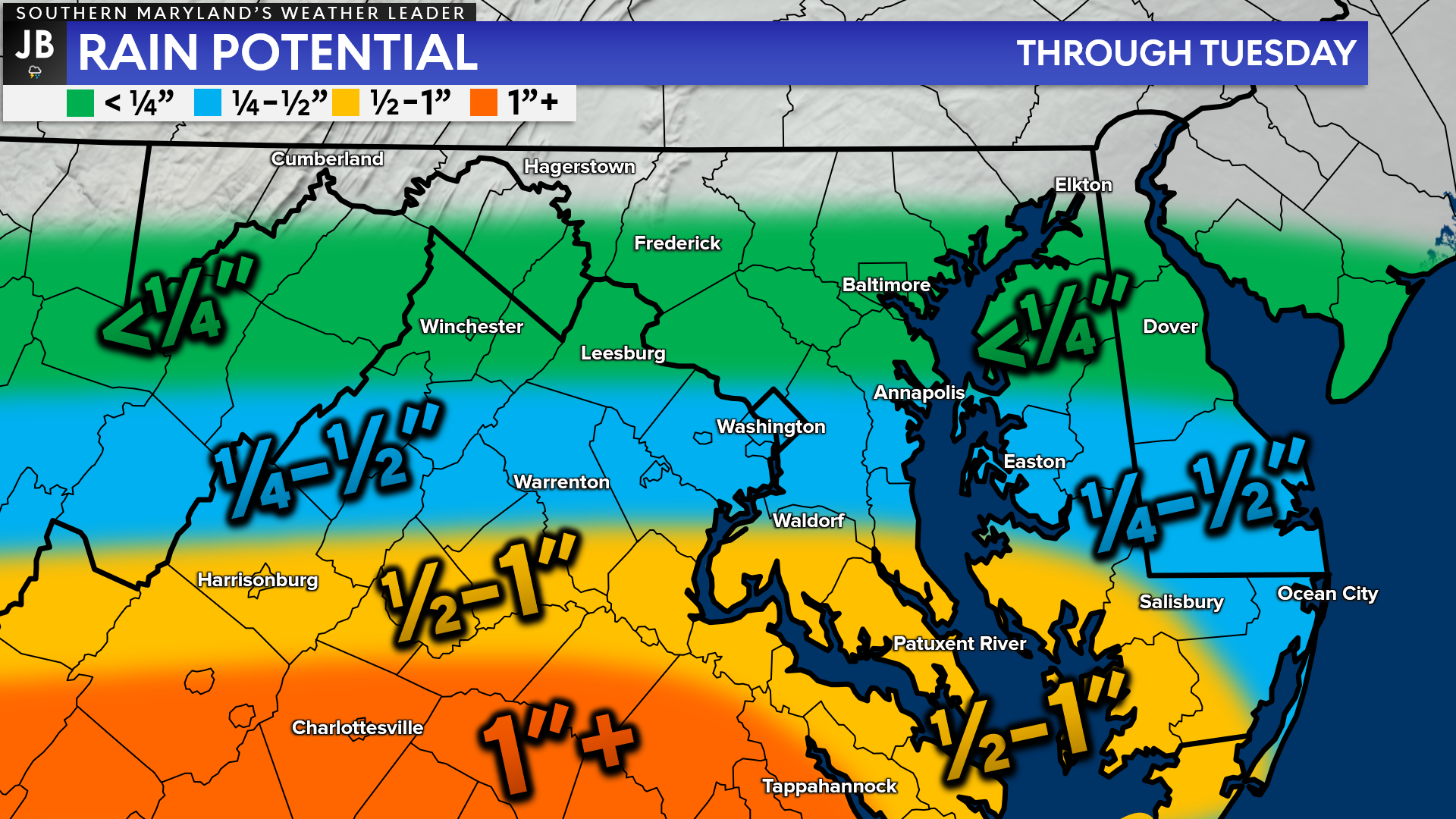
My current expectation would be for our region to see between a half-inch to an inch of rain over the next 36-48 hours. The highest rainfall totals will be found further to the south, where the steadiest rains are likely to set up for a prolonged period of time. Localized areas may see more or less than I show here– thanks to the spotty nature of rainfall!
There are a couple of different scenarios with how this system, and the subsequent rainfall totals, play out.
Less rain
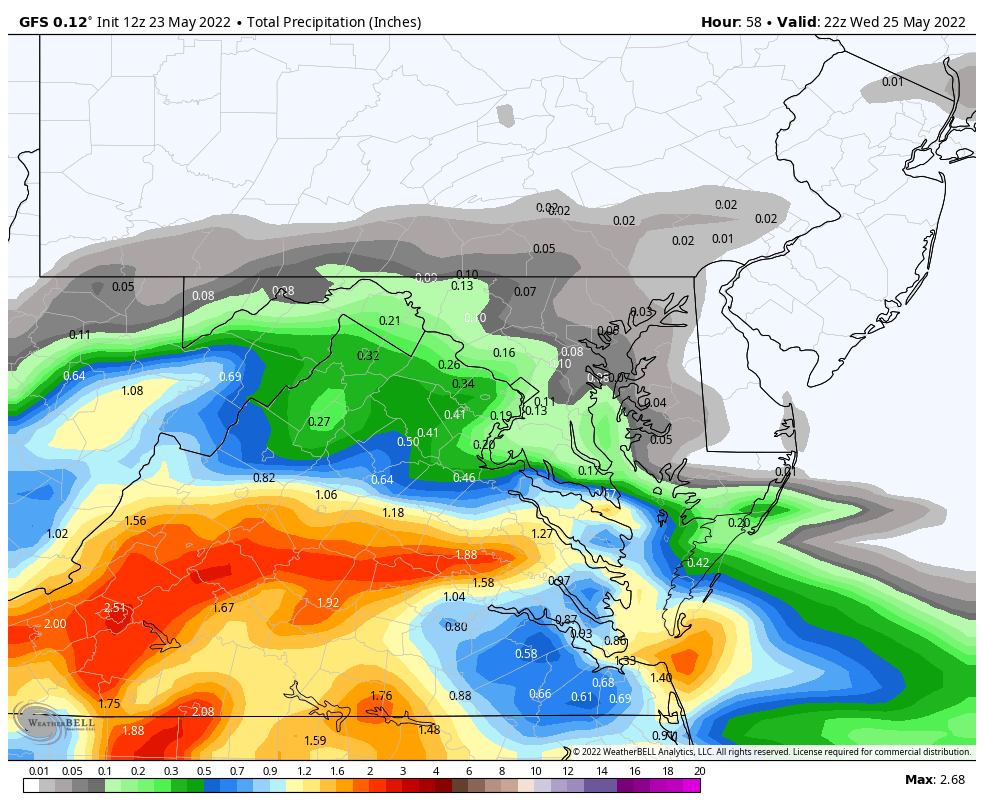
Shown above is the American (GFS) Model. It is far less aggressive with the rainfall potential in our region. It keeps the low pressure to our south weaker and suppressed. The result is that our region ends up on the edge of measurable rainfall, which would result in a largely dry Tuesday.
MORE RAIN
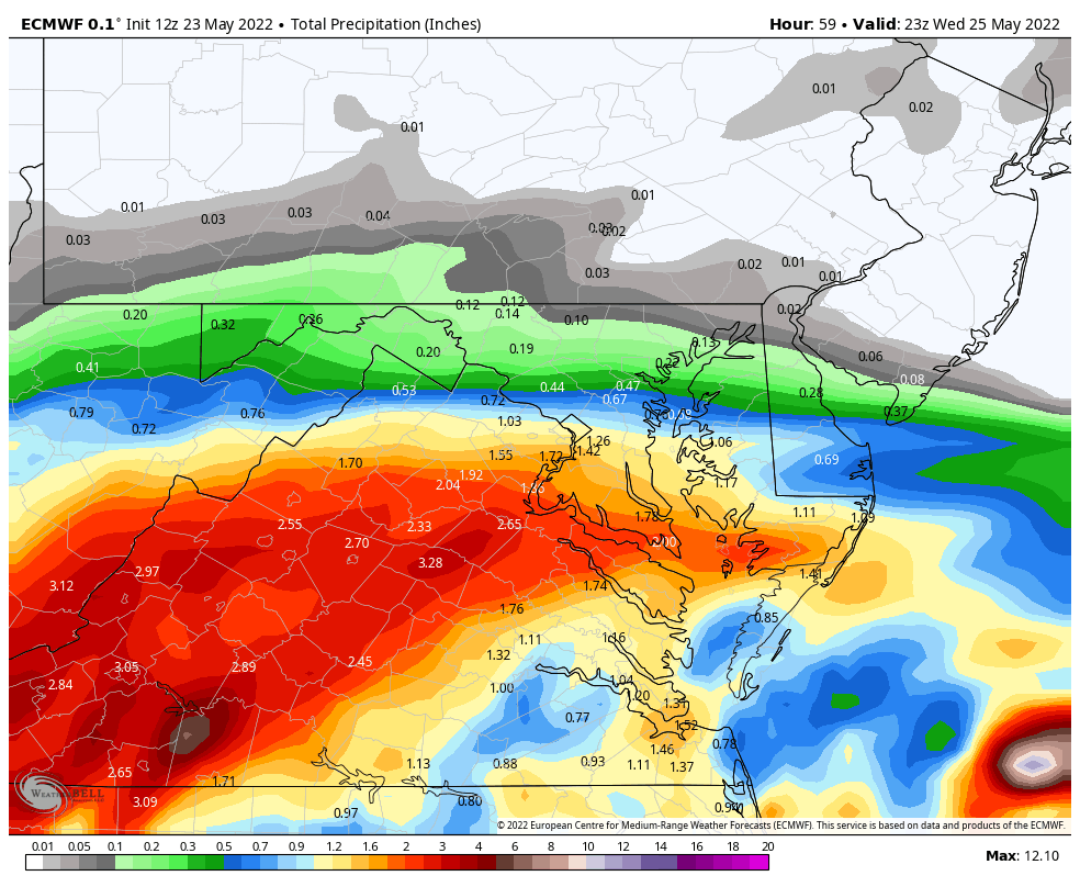
Shown above is the European Model, which is far more aggressive with the rain potential. It keeps our system a tad stronger and nudges it further north. This allows for Southern MD to get in on the 1″+ rainfall potential as rainfall would linger throughout the day on Tuesday before clearing up early Wednesday.
It is unclear which one of these outlier possibilities is more probable. I could see either solution playing out given today’s trends. With that said, I would plan on a wet night tonight with lingering showers possible tomorrow, especially in the morning.
Afternoon and evening plans tomorrow will be largely dependent on how long this system sticks around off the coast. The quicker it can move out, the quicker we can dry out.
At this time, I am not expecting thunderstorms or overly heavy rain with this event. With that said, though, bands of moderate rain will be possible this evening. This could lead to some ponding on area roadways and minor flooding in the zones that saw the most rain yesterday.
Stay with JB Weather for the latest information on Southern Maryland weather. You can always access my forecasts and updates here on the website, on Facebook, on Twitter, on Instagram, and on YouTube.
-JB
Dr. Thomas Hao and Dr. Dylan Schneider offer comprehensive orthodontic services for all ages. Schedule your free consultation today. Visit www.SOMDBraces.com today for more information!
John Bordash
View More PostsJB Weather forecaster John Bordash is working around the clock to provide Southern Maryland, and neighboring communities, with accurate and reliable weather information.