Brought to you by Row House
Here we go again– we are tracking another winter weather threat! As I mentioned in last night’s update, we are tracking multiple threats for winter weather over the next week. The first one comes late Wednesday night into Thursday. While this does not look like a big storm, but any stretch of the imagination, this could be an impactful event because of its timing.
The Setup
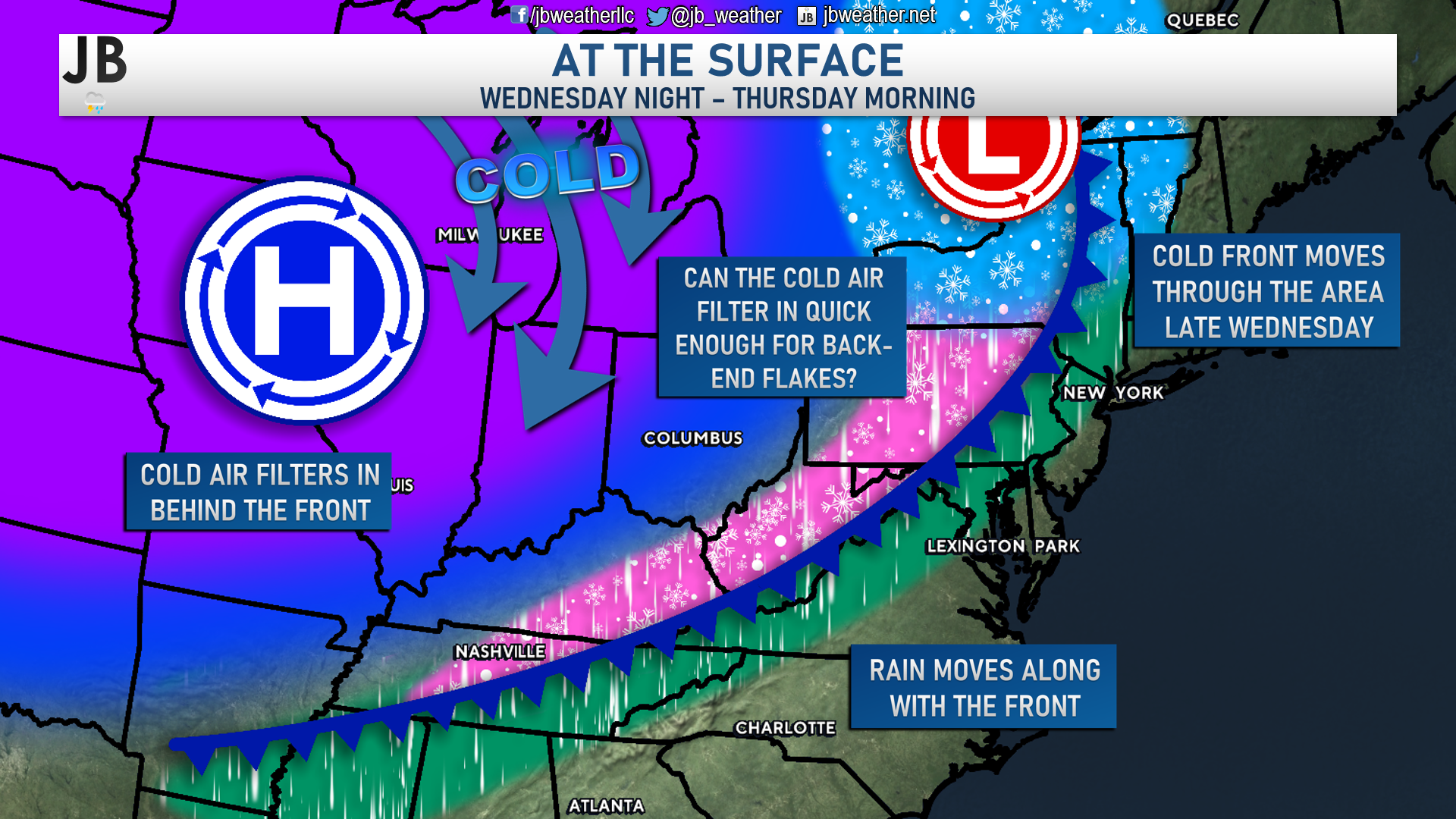
After a seasonally warm day on Wednesday, with temperatures in the middle to upper 40s, we will see a cold front swing through after sunset. This cold front will bring some moisture along with it, in addition to the cold air behind it. We should see this start as rain across much of the region. However, if the cold air can move in quick enough behind this front, we could see the precip end as a period of wintry weather.
This is not necessarily a setup that I am too fond of. Typically in these setups, the cold air lags behind just a tad too much, and the precipitation has a way of not being nearly as robust as shown several days in advance. With that said, though, our guidance has been relatively consistent on this potential to see some light back-end flakes.
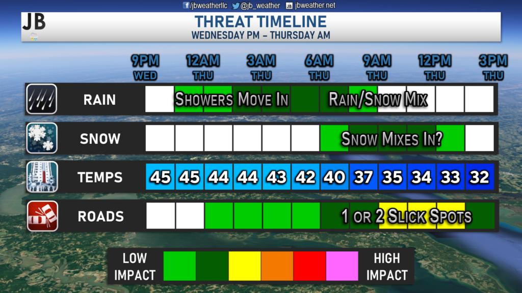
Timing
Shown above is the latest run of our Chesapeake’s Bounty Futurecast, which shows rain starting across much of the region after sunset Wednesday. We may even see a more moderate rain in some locations for a period. This model has the cold air just barely catching up with the moisture and switching some areas over to snow by sunrise. This wouldn’t be a lot. However, our model suggests that this switch over to a couple of hours of snow could occur around the morning rush on Thursday. That timing is what could make this impactful, even though it wouldn’t
Potential Accumulations
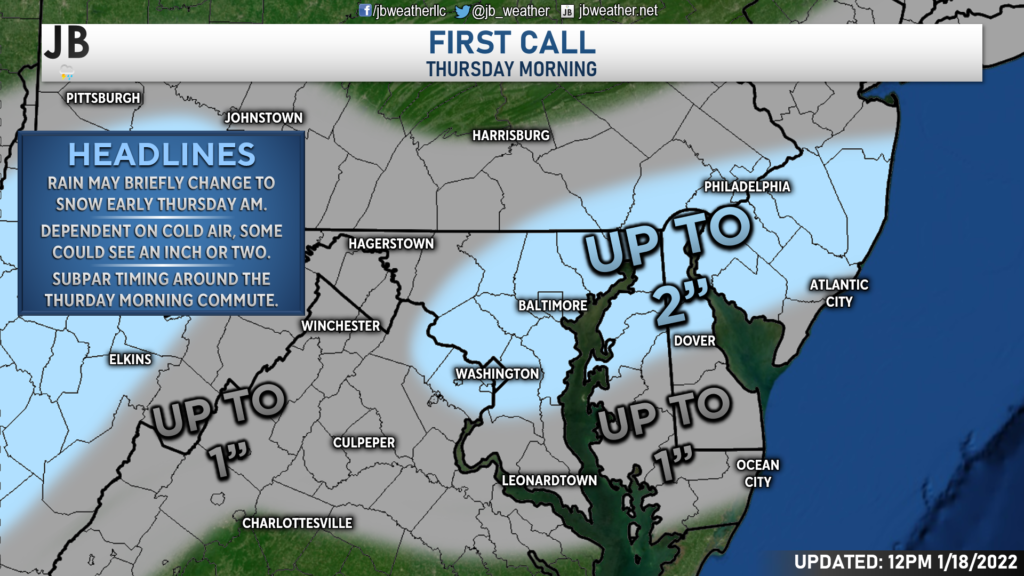
How much snow could we be talking about in the Mid-Atlantic? Likely not much. If the cold air is indeed able to catch up to the moisture in time to cause a transition to snow, we could see a slushy inch or two across the region. I think the highest chances of seeing up to two inches of slushy accumulation would be from about Route 50 (going from DC to Annapolis) up to the Mason Dixon Line. This is where the cold air may rush in quick enough to allow for a couple of hours of snow. North of that region, into southern Pennsylvania, the moisture may be moving out when the cold air comes, hence the lower totals up there. Across Central Virginia and Southern Maryland, totals may be lower due to the cold air potentially lagging too far behind.
We shall see how this works out! This is all largely dependent on that cold air coming in time. If the cold air does not come in on time, there will be very little accumulation, which is totally possible. If the cold air is in time, you could see a little more than I have shown here. We will refine these probabilities on Wednesday when we know more information. With that said, this forecast is low-confidence.
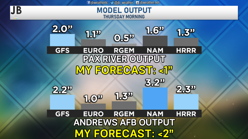
What do our models say? Well, most of our guidance does show accumulating snowfall across Southern Maryland. However, amounts do vary from model to model. I worry that these models may be overestimating just how quickly the cold air is to arrive, hence why my forecast is lower than most of the numbers shown. With that said, though, I think this also shows the wide variety in potential accumulations.
Additionally, I don’t have one model that puts down a lot of snow. All of these totals are not major. The timing of the potential snow burst is what could lead to more moderate impacts.
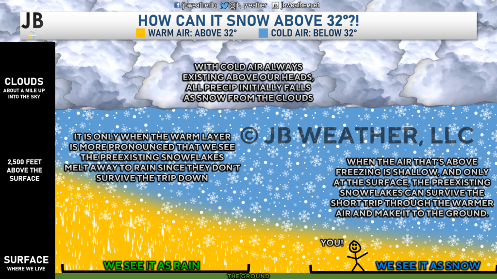
Temperatures will not likely get below freezing for this event. Temperatures will probably start off in the lower to middle 40s before cooling into the lower to middle 30s. One might say in response to that, “Well of course it won’t snow if it’s above freezing! It’ll just be rain.” To that, I say, not too fast! It can snow in the middle to upper 30s, and we have seen it happen many times before. As the diagram above shows, if the cold air layer above our heads is thick enough, then snow will be able to survive the short trip through the warmer air and reach the ground. The game we are playing Thursday morning is how quickly the air above our heads can cool. If a decent chunk of the atmosphere can cool quickly enough, we can see snow.
Impacts
It is difficult to say at this time what exact impacts across the region would be. That is primarily because of how low-confidence it is. With that in mind, it does look like some minor to moderate impacts could be felt Thursday morning in the regions that do flip to snow. Again, this is not likely to be a lot of snow. It is the timing of the potential snow that could lead to problems.
It is hard to speculate on how bad/good area roads would be and if we could see business/school closures/delays. I should have a better idea of all of that tomorrow. I would say right now that some travel and school impacts are certainly possible Thursday morning. It will be essential to stay tuned for additional forecast updates as the picture comes into better focus.
Storm FAQs
How confident are you in your forecast? I am confident that we will have precipitation in the region Wednesday night into Thursday morning. What I feel less confident about is whether or not we see that precipitation flip to snow Thursday morning. I hope to have more answers on this threat Wednesday morning, but the details are still likely to be sketchy, at best. This forecast is very much a low-confidence one.
How much snow will I get at my house? Check out the accumulation map. Generally, I’m expecting less than an inch for much of the region. Some spots from DC to Baltimore, and out towards the Philadelphia region, could see up to two inches.
Could more or less snow fall than currently forecast? Absolutely. In order for more snow to happen, we would need to see the cold air really rush in here Wednesday night to allow for a longer period of potential snow. Additionally, heavier precipitation could lead to more snow. On the flip side, if the cold air lags behind too much, we will see our snow chances fizzle out and just leave us wet.
30% chance: Nothing
40% chance: Less than an inch
20% chance: 1-2″
10% chance: 2-3″
As you can see, there is a greater chance of us seeing nothing as opposed to seeing widespread 1-3″ accumulation. With that said, the category with the highest probability is seeing less than an inch. There is a high bust potential here.
Will we see any of the dreaded wintry mix? That does not appear too likely, right now. While we may see a brief transition to sleet before going to snow, I would not expect a prolonged duration of it.
When will this event start? Rain likely moves in late Wednesday night, between sunset and midnight. A transition to snow may occur around, or just after, sunrise on Thursday.
When will the heaviest fall? Most likely during the mid-morning hours, but we’re likely not talking about heavy snow.
Will the snow stick? If snow does indeed fall, we should see at least some accumulation on colder surfaces, such as decks, car tops, and the grass. Roadway accumulation may be tricky to do. However, if we see more snow than I am forecasting, which noted above has a 30% chance of happening, then we could see some minor accumulation on secondary roads.
Will this be heavy, wet snow or dry, powdery snow? With temperatures hovering right around freezing throughout this event, we are likely to see more of a wet snow.
What will conditions be like after the event? We could likely see the precip wrap up between late morning and early afternoon on Thursday. We will likely be left with a mix of sun and clouds with temperatures around freezing. Thursday night looks cold, with temperatures going into the 20s! This could cause 1 or 2 slick spots to form by Friday morning.
Summary
The forecast for Wednesday night into Thursday morning is a difficult one! We are playing a game of how quickly cold air can get in here while moisture is around. This is not a game that I am too fond of. We have seen this type of setup lead to busted forecasts before. With that said, many of our models do like the idea of a period of a couple of hours around/after sunrise on Thursday to see some snow. Temperatures will be marginal at best. Right now, I am forecasting up to an inch of snow for most. However, that could change either way, depending on the timing of the cold air. As a result, this is a low-confidence forecast with high bust potential. However, if we do see snow, we could see some impacts on the Thursday morning commute.
Stay with JB Weather for the latest information on impacts here in Southern Maryland. You can always access my forecasts and updates here on the website, on Facebook, on Twitter, and on YouTube. JB Weather is Southern Maryland’s Weather Leader, and I am working around the clock to keep you ahead of any storm!
-JB

Row House SOMD is more than just a workout; it’s about people, connection, strength and community. Our classes offer varied programming, helping you progress your workout and avoid plateaus. In our boat there’s a seat for everyone, so contact us TODAY at 301.686.7788 and mention JB Weather to schedule a FREE introductory class. Also receive a FREE GIFT when you sign up for a membership.
John Bordash
View More PostsJB Weather forecaster John Bordash is working around the clock to provide Southern Maryland, and neighboring communities, with accurate and reliable weather information.
1 thought on “Forecast: Winter Weather Possible Thursday Morning”
Comments are closed.
[…] [ January 18, 2022 ] Forecast: Winter Weather Possible Thursday Morning Top Stories […]