Brought to you by Chesapeake Orthodontics
February has featured an active pattern across the Mid-Atlantic and Northeast! Saturday will look to offer another shot of rain for all with mix and snow possibly for northwestern zones. This comes as a system cuts to our northwest to deliver a weekend warm-up before another arctic plunge next week.
Our Cedar Point Federal Credit Union Futureview model shows moisture overspreading the region Saturday morning and midday. Temperatures look to be cool enough to allow for an initial bout of snow and wintry mix west of I-95. However, the warm air will eventually win out, and transition everyone to rain. The rain will continue into Sunday and could be heavy at times.
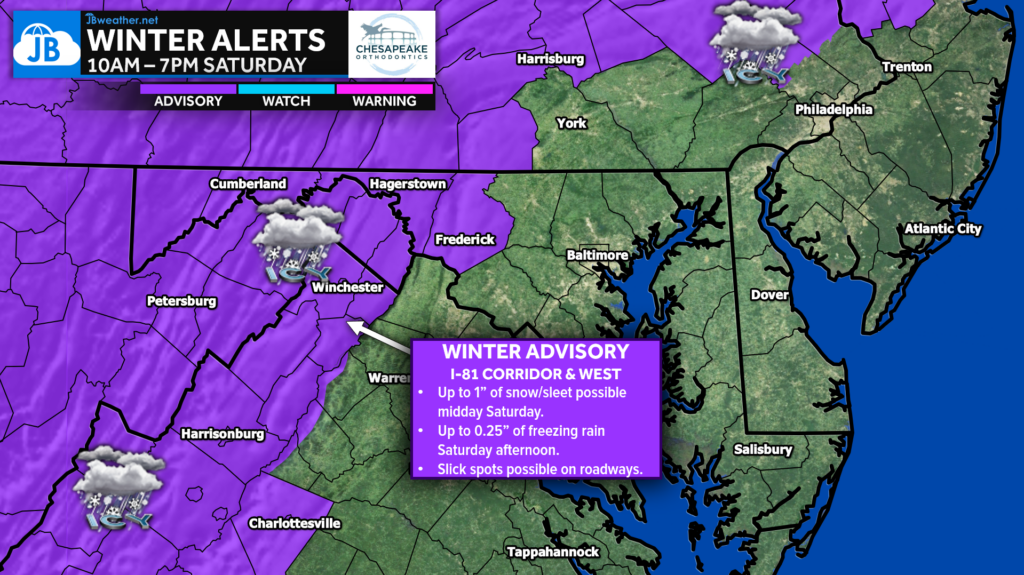
Winter Weather Advisories have been issued for the western zones, shaded in purple, from 10am through 7pm Saturday. These regions are the most likely to see a period of wintry mix that could cause elevated impacts. Slick spots on area roadways will be possible.
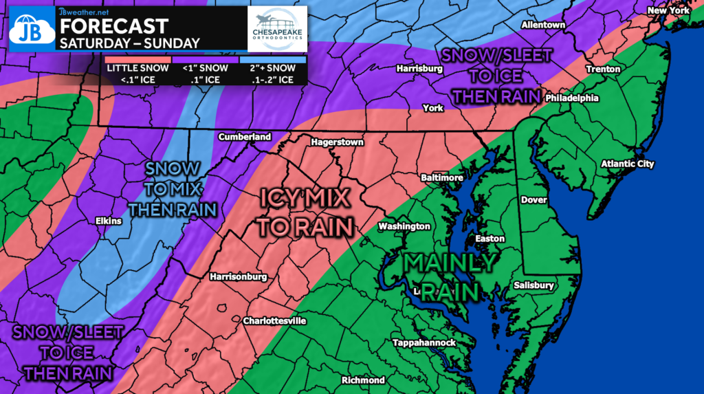
Up to 2″+ of snow looks possible for the Appalachian mountains and northern Pennsylvania before going to mix then rain. The Highlands and southern PA look prime to see some snow/sleet before seeing up to a tenth of an inch of ice before going to rain. The Piedmont will see a quick bout of an icy mix before prolonged rain. The coastal plain will see almost all rain that could be heavy at times.

Our Futureview model suggests that the coastal plain could see upwards of 1-2″+ of rain! This could lead to some flooding for prone locations. More importantly, this will help out with the ongoing drought that developed this fall.
All-in-all, expect a weather-impacted weekend across the Mid-Atlantic. Expect a round of wintry mix if you have interests northwest of I-95. You will see more winter weather impacts the further north and west you head. This will set us up for a warm Sunday with temperatures potentially making a run at 60°. However, the cold air will come crashing back in behind this system. That cold air could set up the threat of winter weather by mid next-week!
Stay with JB Weather for the latest information on impacts here in Southern Maryland and across the Mid-Atlantic. You can always access my forecasts and updates here on the website, on Facebook, on Twitter, on Instagram, and on YouTube. JB Weather is the Mid-Atlantic’s Weather Leader, and I am working around the clock to keep you ahead of any storm!
Dr. Thomas Hao and Dr. Dylan Schneider offer comprehensive orthodontic services for all ages. Schedule your free consultation today. Visit www.SOMDBraces.com today for more information!
John Bordash
View More PostsJB Weather forecaster John Bordash is working around the clock to provide Southern Maryland, and neighboring communities, with accurate and reliable weather information.
1 thought on “Forecast: Wintry Mix Possible Saturday West of I-95”
Comments are closed.
[…] Forecast: Wintry Mix Possible Saturday West of I-95 […]