Brought to you by Berkshire Hathaway HomeServices PenFed Realty
Today is shaping up to be an active day as many people look to get their Memorial Day Weekend started. An incoming cold front will look to bring a few rounds of heavy rain and severe storms to the region throughout the afternoon and evening. Moderate to high impacts will be possible across the Mid-Atlantic today, as a result.
We are off to a mild start this morning with temperatures already in the middle to upper 60s and dewpoints also in the 60s before sunrise. These conditions will set the stage for storm energy to develop throughout the atmosphere to support the potential of strong storms later today as the front moves through.
Our Chesapeake’s Bounty Futuercast has been quite aggressive with the potential of storms today. Thanks to the warm and humid conditions, we could see two or three different lines of storms work through today.
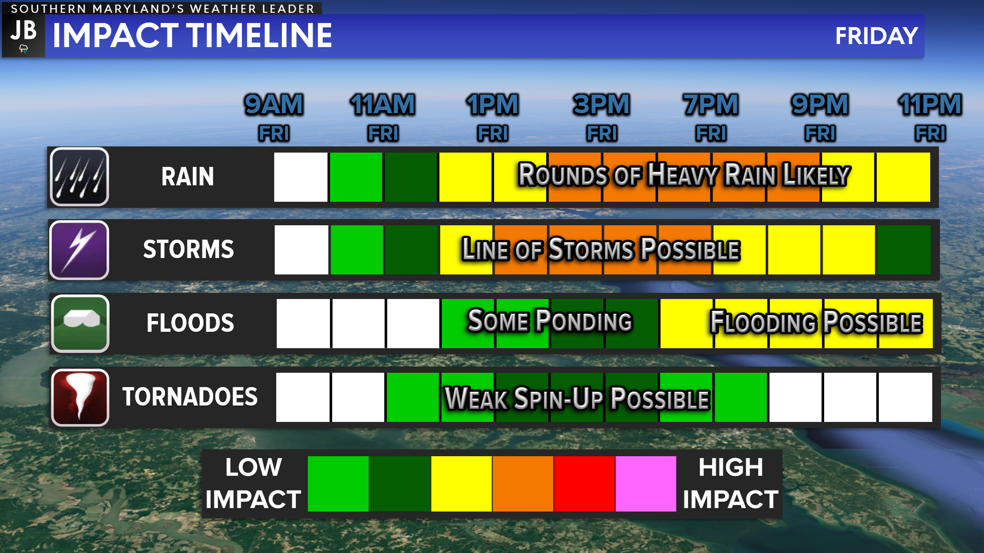
The first line of storms is likely to move through around lunchtime today, between 11am-2pm. This initial line will likely have the highest severe weather potential. These initial storms will race eastward across the region, and will have the most amount of storm energy and atmospheric shear to tap into. This means that heavy rain, damaging winds, and even a brief spin-up tornado or two will be possible as this initial line works through.
Behind this first line, we may see additional storms fire up just behind it. These subsequent storms should not be as severe as they move through between 2-5pm. The tornado risk will be lower with these storms, but heavy rain and damaging winds will remain possible.
Our last round of weather will move through this evening, after 7pm. Another band of heavy rain is likely to work through the region. Since the earlier storms will have used up much of the storm energy we are generating this morning, the vast majority of this last round should not be severe. However, given the heavy rain from earlier rounds, the additional rain from this last round could spark off flooding.
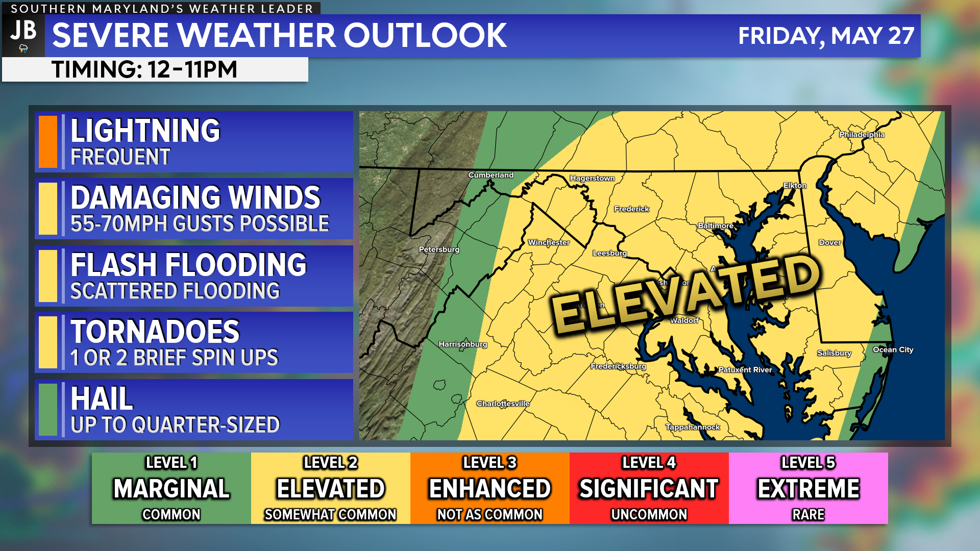
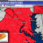
This morning, most of our region has been placed under a Level 2 “Elevated Risk” of severe weather throughout the afternoon and evening. Damaging winds and flash flooding will be the primary risks. However, we will also have to monitor the threat of a brief spin-up tornado or two with the first round of storms this afternoon!
Overall, the greatest severe weather risk will be along and east of I-95 this afternoon and evening.
ughout the day tomorrow.
Keep in mind that severe weather forecasting is far from a guarantee of anything. The goal of these forecasts is to alert you to the potential of storms, not a promise of storms.
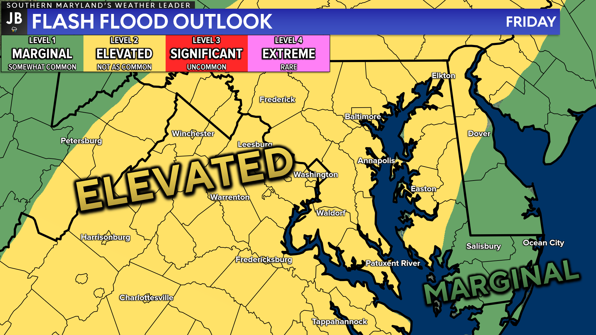
As mentioned before, there will be a threat of flooding across the region today. The National Weather Service has placed our region as being under a Level 2 “Elevated Risk” of flash flooding. This scale is a bit different than the severe risk scale. We only use 4 risk categories with flooding, whereas 5 categories are used to assess severe weather risks. This means that a Level 2 risk is much more substantial and worrisome than you may assume.
The atmosphere will possess a high content of water in it today. This could allow for any storms to put down a lot of rain in a short amount of time. This could lead to several instances of flash flooding across the region! This is the most likely to become an issue the further into the evening we head. Therefore, it will be important to stay aware if you are traveling tomorrow evening.
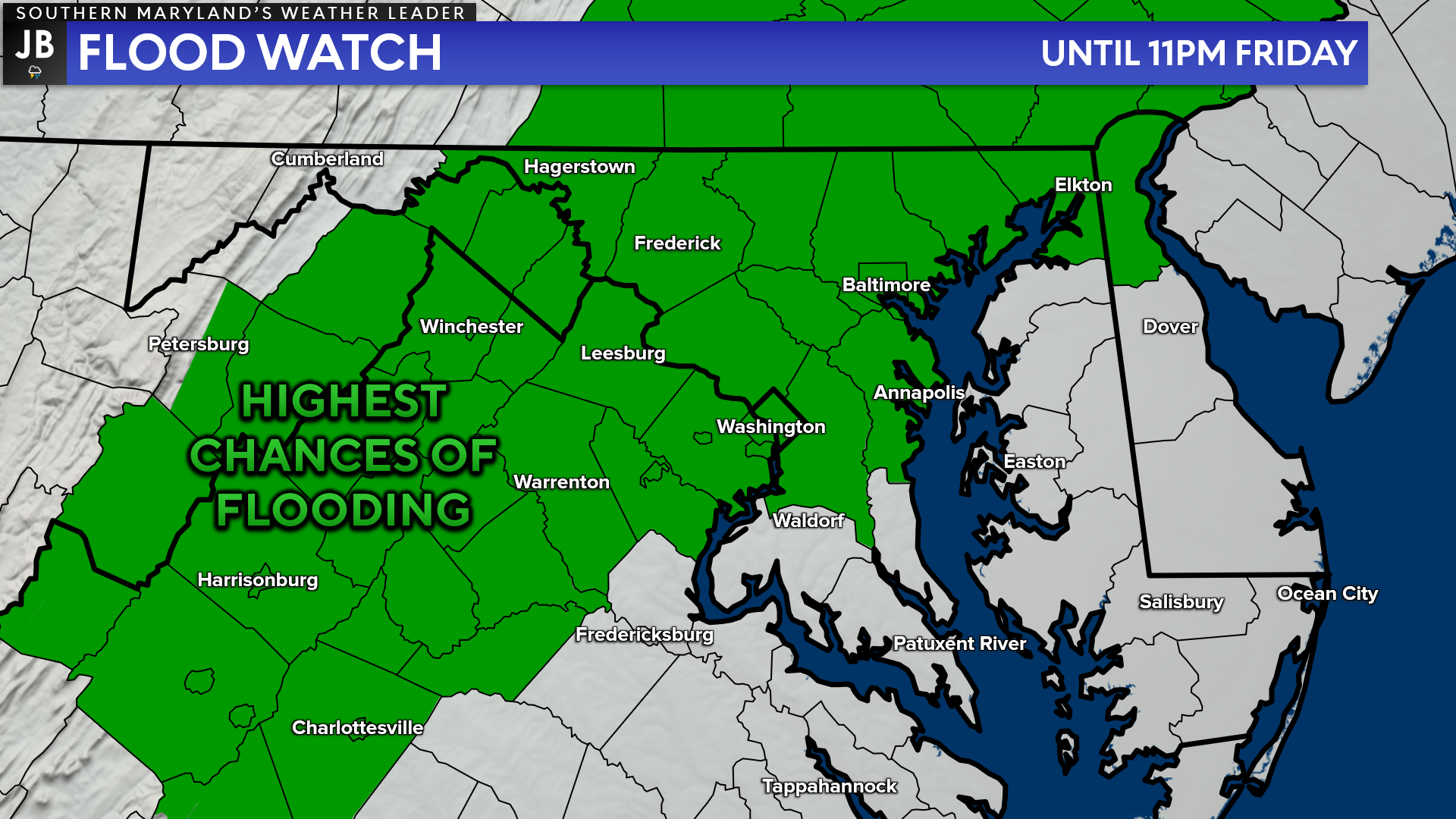
With this threat of flooding, many northwestern zones have been placed under a FLOOD WATCH until 11pm Friday night. While this green shaded zone is where the flooding risk will be the highest, I believe that everyone will have the threat of flooding today. Some locations that see consistent rounds of heavy rain could see up to 1-2″ of rain!
All in all, today will be a day to stay weather aware. The risk of severe storms and flooding this afternoon and evening is elevated. Several rounds of storms will work through the region beginning around lunchtime. This will likely impact the evening commute and travel plans you have! I would suggest against voluntary travel this evening, as you are likely to encounter instances of flooding and storms! We will see the weather begin to clear up overnight tonight and into tomorrow morning.
It will be important to stay weather aware and to be prepared for weather conditions that could change quickly! We may see severe weather alerts get issued throughout the afternoon and evening, so you will want to have a way to get those alerts (JB Weather is a great choice)! I will have an update to this forecast later on this morning, likely around 9am.
Stay with JB Weather for the latest information on impacts here in Southern Maryland. You can always access my forecasts and updates here on the website, on Facebook, on Twitter, on Instagram, and on YouTube. JB Weather is Southern Maryland’s Weather Leader, and I am working around the clock to keep you ahead of the storm!
-JB

Real Estate now! Not sure where to start? View our Southern Maryland inventory of homes, land, farms and commercial properties on penfedrealty.com. Engage with our planning tools to determine your next real estate lifestyle decision, choose your realtor as a trusted advisor. Experience the difference with service and support from real estate’s forever brand!
John Bordash
View More PostsJB Weather forecaster John Bordash is working around the clock to provide Southern Maryland, and neighboring communities, with accurate and reliable weather information.

1 thought on “Friday’s Forecast: Strong Storms & Flooding Possible”
Comments are closed.
Thanks for the great forecast!!