Brought to you by Calvert Title Company
Alright, folks, we’re getting close to that time of the year again! Hurricane Season in the Atlantic Basin officially starts in less than a month– on June 1st. While tropical systems can form any time of the year, June 1st – November 30th is often regarded as the most likely time to have a tropical system develop in our part of the world.
To get you ready for Hurricane Season, the National Oceanic and Atmospheric Administration (NOAA) has deemed this week Hurricane Preparedness Week. In partnership with our federal partners and agencies, I want to use this week to help prepare our communities for Hurricane Season. Each day this week we will be covering a different topic to help you get ready for the upcoming season. Today, we are talking about Evacuation Zones!
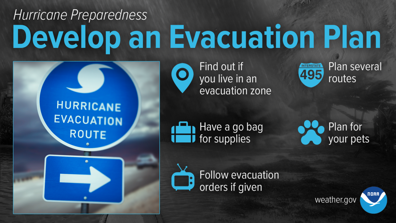
A tropical system can form suddenly and with very little notice. Many of us know that it does not take much for our region to experience high impacts from tropical systems, even low-rated ones. Knowing if you live in a hurricane evacuation zone, and where to go if you do, is one of the key pieces of knowledge you must know.
Find out if you live in a hurricane evacuation zone. You may also need to leave if you live in a flood-prone area or in a mobile home outside a hurricane evacuation zone. Now is the time to begin planning where you would go and how you would get there.
You do not need to travel hundreds of miles. Your destination could be a friend or relative who lives in a well-built home outside flood-prone areas. Remember, your safest place may be to remain home. Be sure to account for your pets in your plan.
Both the Maryland and Virginia Departments of Emergency Management have developed evacuation zones in the event of a tropical system. These zones are developed to target any evacuations to high-risk areas. Tiered evacuation zones were developed in close coordination with local emergency managers throughout those high-risk areas based on the most up-to date engineering data for the region. In Maryland, zones are designated A through C. In Virginia, zones are designated A through D. They provide residents with clarity on whether they should evacuate in an emergency or shelter at home, based on their physical street address and the nature of the emergency event.
You can find both plans linked below. Both sites have interactive maps that allow you to search and zoom in/out to see who is included.
In addition to these links, I have also provided general outlines of which communities in our local areas are under what evacuation zone, below. The format of the lists below is- Evacuation Zone: Town/Area
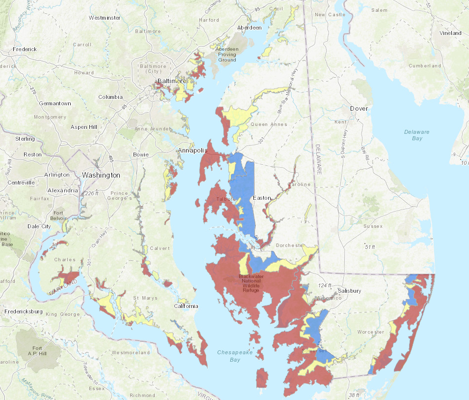
Anne Arundel County
- A: Beverly Beach
- A: Mayo
- A: Shady Side
- A: Shelby-on-the Bay
- B: Parts of Annapolis
- B: Deale
- B: Edgewater
- B: Churchton
- B: Galesville
- B: Highland Beach
- B: Hillsmere Shores
- B: Londontowne
- B: Rose Haven
- B: Skidmore
- B: Springdale
- B: Woodland Beach
Calvert County
- A: Parts of Broomes Island
- A: Parts of Chesapeake Beach
- A: Cove Point
- A: Parts of North Beach
- A: Solomons Island
- B: Parts of Broomes Island
- B: Parts of Chesapeake Beach
- B: Dowell
- B: Parts of Hallowing Point
- B: Parts of Lusby
Charles County
- A: Along Allens Fresh Run
- A: Benedict
- A: Parts of Bryans Road
- A: Cedar Point Neck
- A: Cobb Island
- A: Parts of Indian Head
- A: Parts of Marbury
- A: Morgantown
- A: Parts of Nanjemoy
- A: Parts of Newport
- A: Parts of Pisgah
- A: Along Popes Creek
- A: Parts of Port Tobacco
- A: Swan Point
- B: Parts of Bryans Road
- B: Issue
- B: Parts of Port Tobacco
- B: Mt. Victoria
- B: Parts of Nanjemoy
Prince George’s County County
- A: Parts of Accokeek
- A: Parts of Aquasco
- A: Parts of Eagle Harbor
- A: Parts of Fort Washington
- A: Along the Patuxent River
- A: Parts of Piscataway
- B: Parts of Accokeek
- B: Parts of Aquasco
- B: Parts of Eagle Harbor
- B: Parts of Fort Washington
- B: Along the Patuxent River
- B: Parts of Piscataway
St. Mary’s County
- A: Coltons Point
- A: Parts of Chaptico
- A: Dameron
- A: Golden Beach
- A: Parts of Ridge
- A: Scotland
- A: Parts of St. Inigoes
- A: Piney Point
- A: St. George Island
- A: St. Mary’s City
- A: Tall Timbers
- A: Whites Neck
- B: Abell
- B: Avenue
- B: Along Brenton Bay
- B: Parts of Bushwood
- B: Along St. Clement Bay
- B: Parts of Valley Lee
- B: Parts of Wicomico Shores
- C: Parts of Callaway
- C: Parts of Great Mills
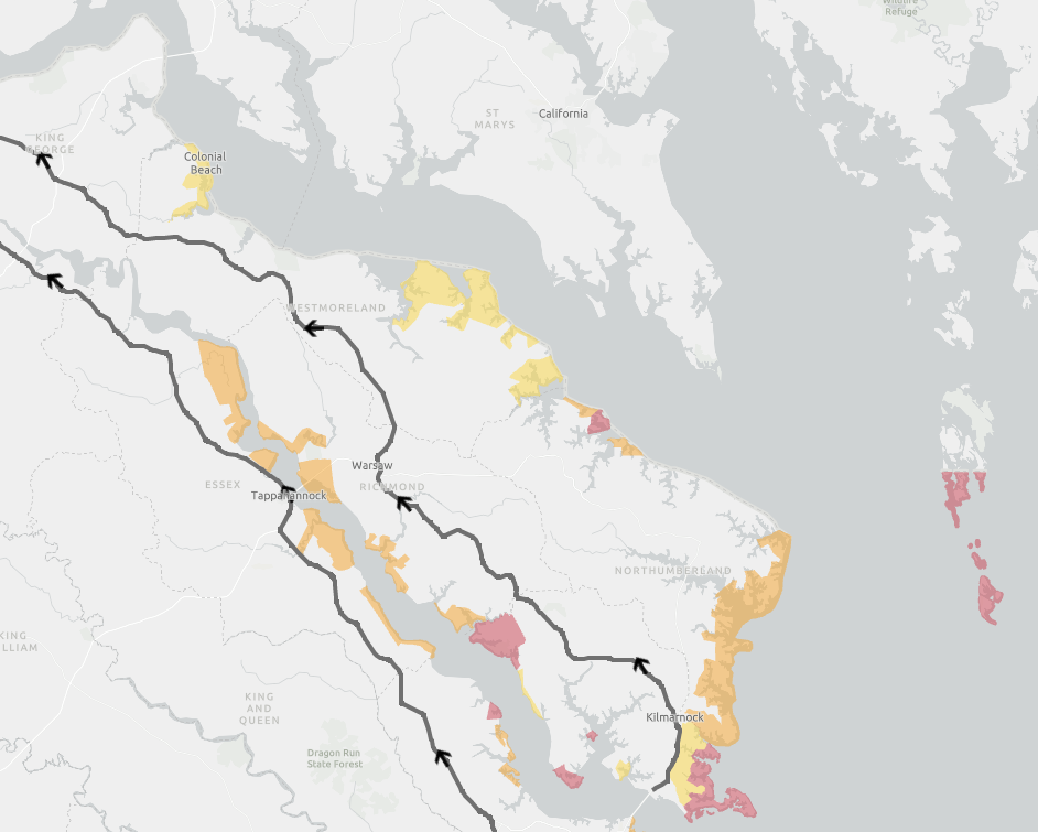
Westmoreland County
- C: Coles Point
- C: Colonial Beach
- C: Erica
- C: Parts of Kinsale
- C: Meter
- C: Sandy Point
- C: Meter
Be ready for hurricane season. Today you can determine your personal hurricane risk, find out if you live in a hurricane evacuation zone, and review/update insurance policies. You can also make a list of items to replenish hurricane emergency supplies and start thinking about how you will prepare your home for the coming hurricane season. If you live in hurricane-prone areas, you are encouraged to complete these simple preparations before hurricane season begins on June 1.
Stay with JB Weather for the latest information on Southern Maryland weather. You can always access my forecasts and updates here on the website, on Facebook, on Twitter, on Instagram, and on YouTube.
-JB
Brought to you by Calvert Title Company. Calvert Title Company is guiding you HOME one closing at a time! Check out https://calverttitle.com/ today!
John Bordash
View More PostsJB Weather forecaster John Bordash is working around the clock to provide Southern Maryland, and neighboring communities, with accurate and reliable weather information.