Brought to you by Chesapeake’s Bounty
Yesterday we saw Hurricane Ian make landfall near Punta Gorda, Florida as a strong Category 4 hurricane. Ian has been moving across the Florida peninsula over the last 18 hours and has weakened significantly thanks to the lack of warm water. However, Ian is not done bringing impacts to the US.
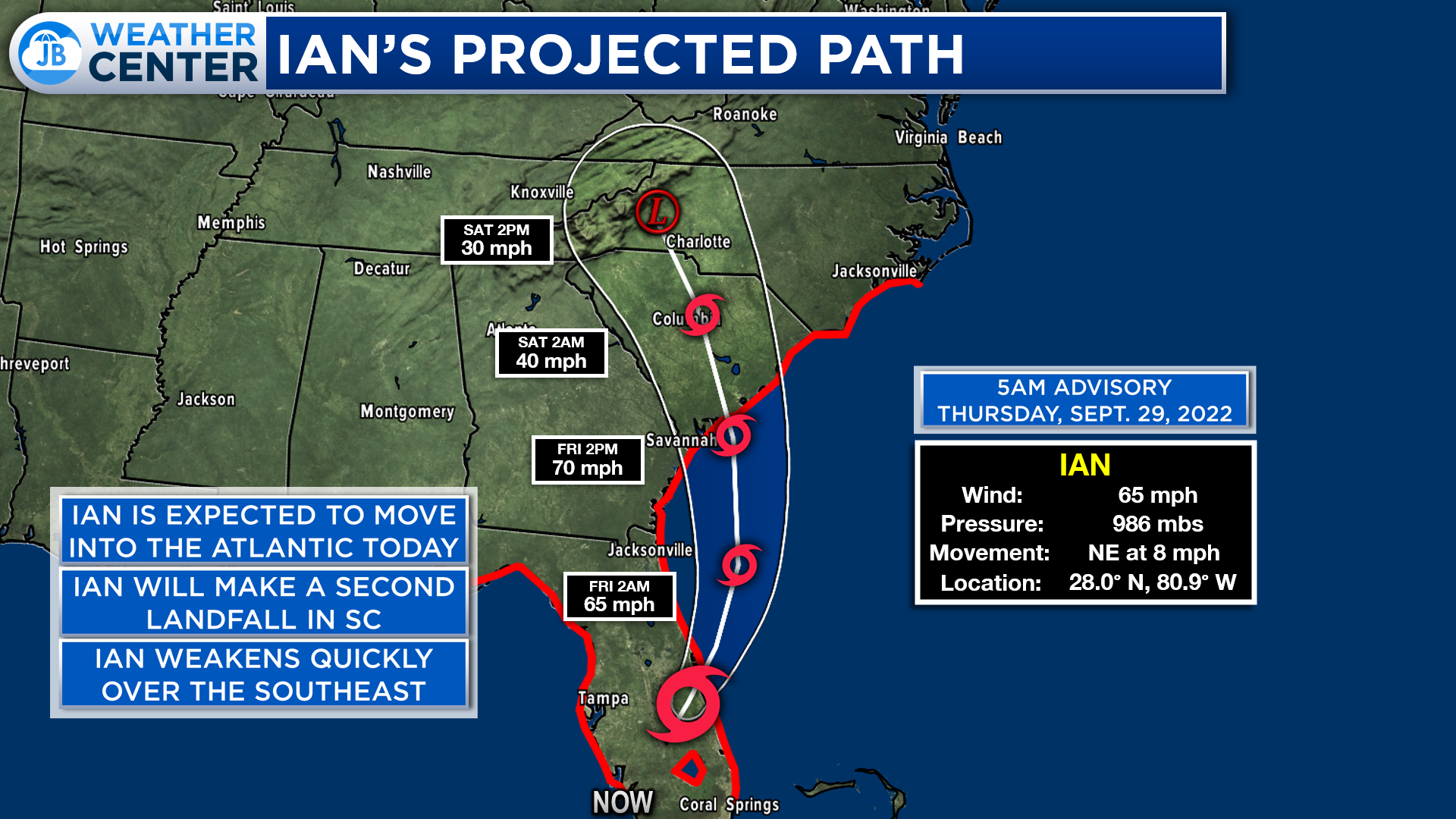
With Ian’s weakening, the storm has been downgraded to tropical storm status. We are likely to see Ian emerge back over the waters of the Atlantic later today as it exits Florida. We will see the storm take a northward turn and look to make landfall in South Carolina late Friday. Some additional strengthening is possible before Ian makes its second landfall. However, Ian will quickly weaken as he moves inland, over the Southeast.
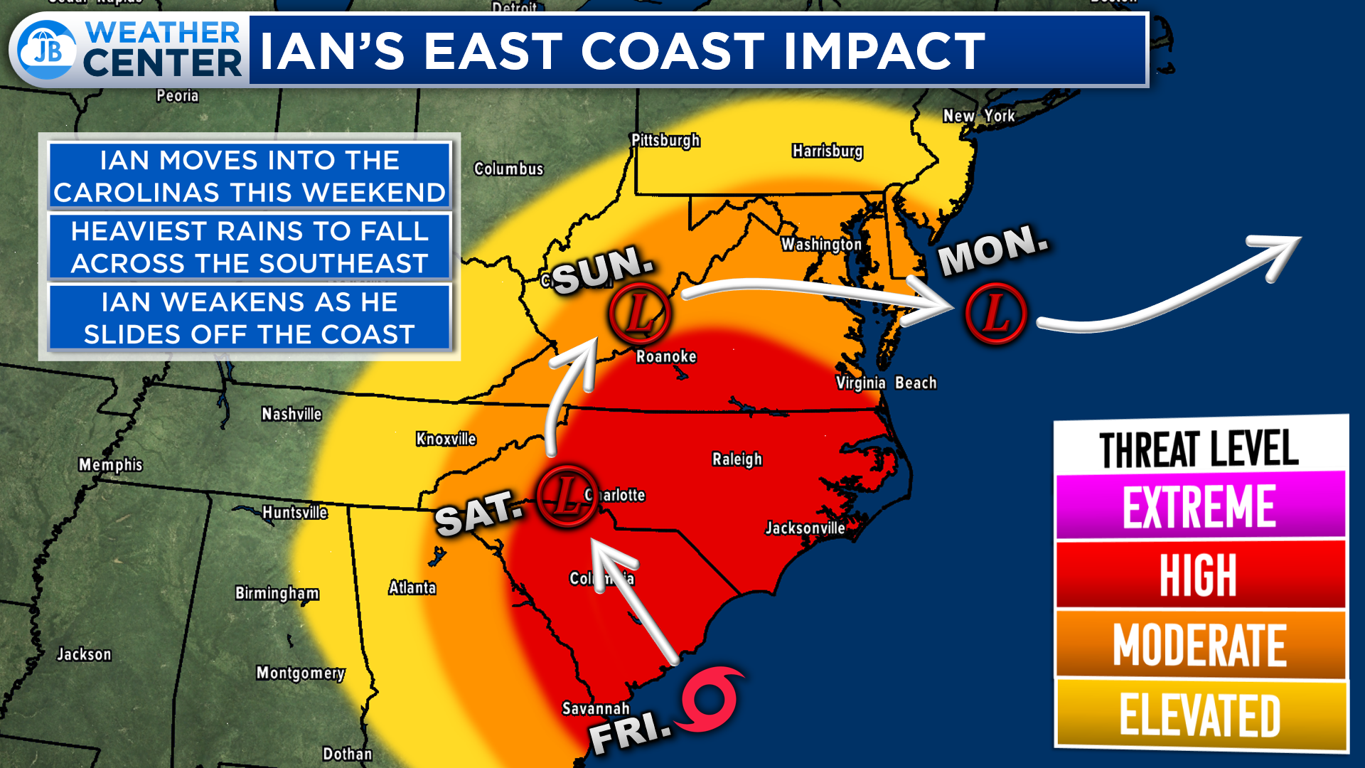
Even though we will see Ian weaken over the Southeast, we are likely to see impacts from the storm spread across much of the Southeast and Mid-Atlantic. The highest impacts will be felt near the point of his second landfall. Moderate impacts will encompass a wide area, including Southern MD, as Ian works inland.
After moving inland, we will likely see Ian move northward along the Appalachian Mountains before sliding back out to see next week. It will take a few days though to get Ian out of our hair.
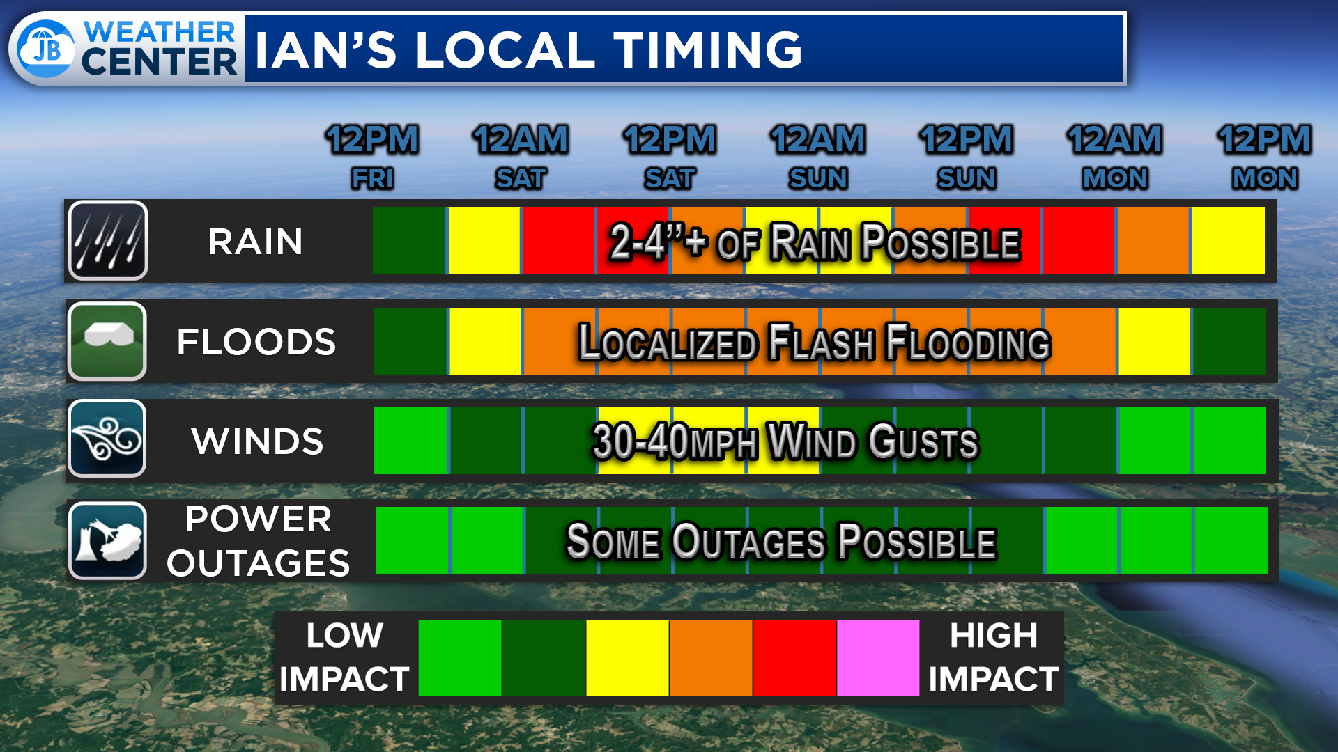
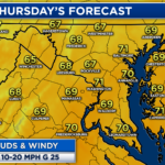
In Southern MD, we are likely to see rain from Ian move in as soon as Friday afternoon. The initial push of rain will pick up after sunset on Friday, and continue through Saturday afternoon. This rain is likely to be heavy at times. We will then likely see the rain break up somewhat, becoming more scattered throughout the rest of the weekend. Another push of heavy rain is possible during the second half of Sunday, into Monday. Flooding could become a concern. We could see wind gusts as high as 40mph at times, but they will not be sustained there throughout the event. However, we could see some outages.
I have said over the last few days, I do not think that we will see the high-end impacts that we saw with other tropical systems over the last few years (like Ida and Isaias). We will see a high rain impact, but the wind and severe weather threats are quite low.
Futurecast largely agrees with my general timing of things. You can see the rain kicking off during the day on Friday and turning heavier overnight. I do think that Futurecast is underplaying how heavy the rain could be. We should, though, see a break in the action by later in the day Saturday, with just scattered periods of rain (which could still be heavy). We likely see the rain pick back up on Sunday.
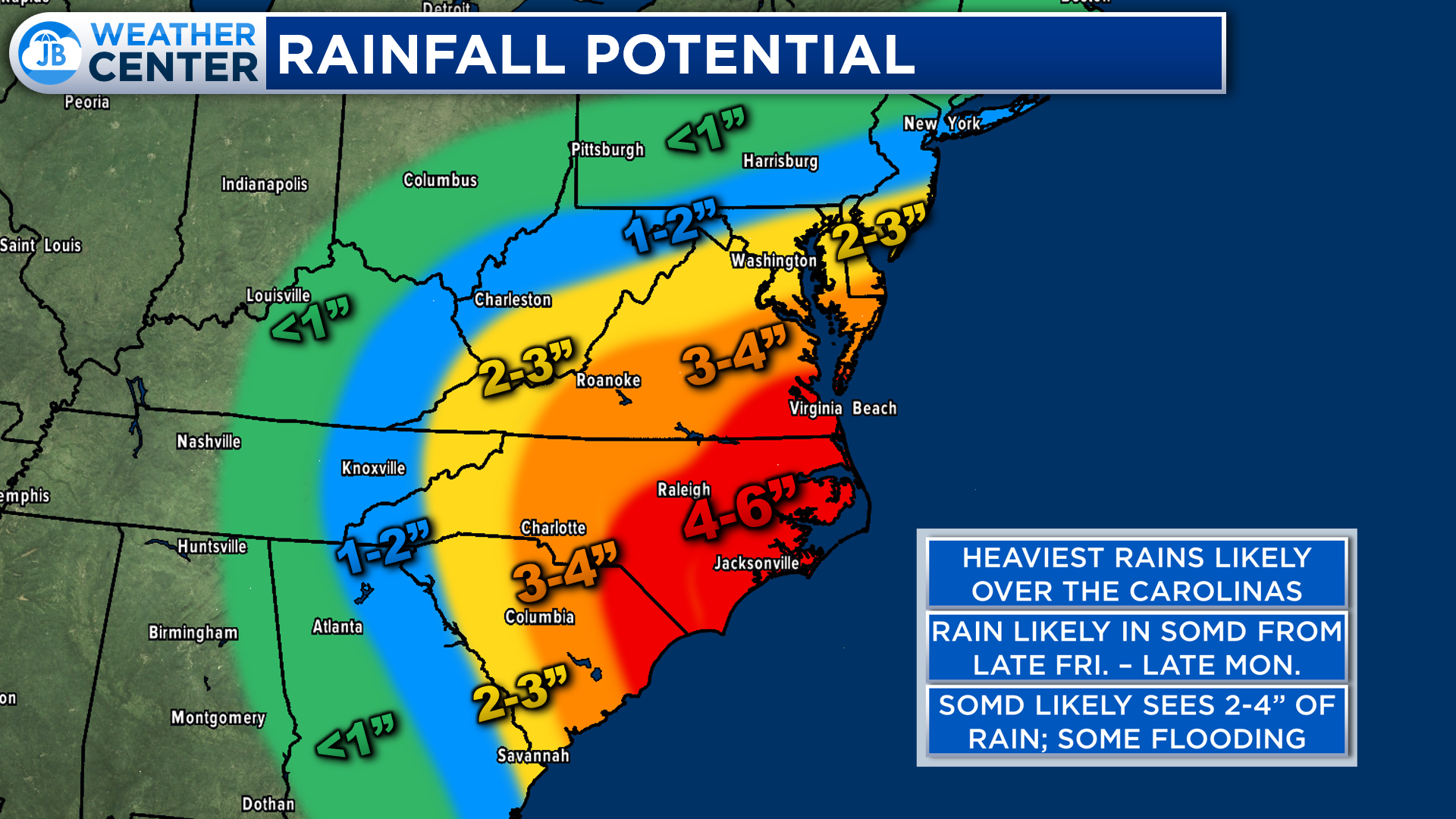
The heaviest rains from Ian are likely to fall across the Southeast, in the Carolinas. We will see that axis of heavy rain includes parts of the Mid-Atlantic, too. Southern MD could see as much as 2-4″+ of rain between Friday and Monday. Rain totals will gradually lessen the further north you head.
We have been dry recently, which does tamper down the flooding threat somewhat. However, we could still see localized flash flooding, especially if we end up on the higher side of that range. I would be prepared for the possibility of seeing flash flooding, just in case.
Thankfully, the severe weather threat with this storm is quite low in our region. Unlike other tropical systems over the years, I do not think that we will see a high tornado threat, at all. With that said, it is something I will monitor. But, I really don’t see this aspect of the forecast becoming a high-impact thing.
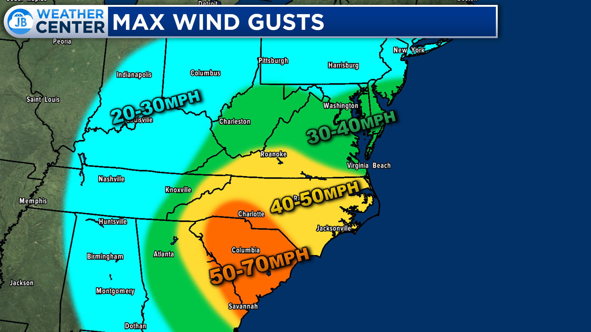
The highest winds from this storm will be felt down in the Carolinas. That is where 50-70mph gusts will be possible, which could cause widespread outages. Our region will likely only get in on 30-40mph gusts. While that is still elevated, and something to take seriously, these will be nothing like the wind gusts we saw with prior systems. Those 30-40mph gusts will not be sustained over the 4-day period. They are likely to be just that, gusts. However, some power outages could be possible.
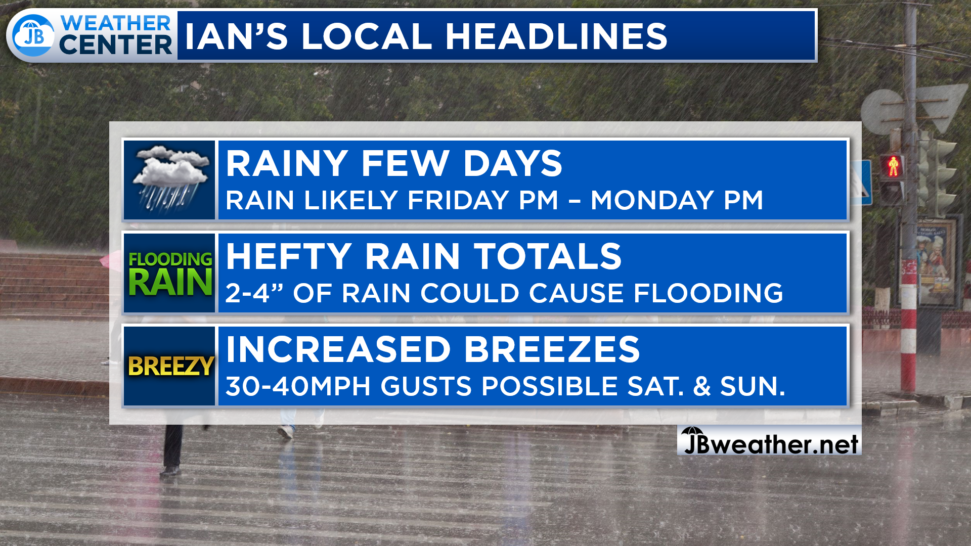
All in all, the biggest impact we are likely to see from Ian is likely to come from rain. We could see 2-4″+ of rainfall between midday Friday and late day Monday. This could cause some flooding issues. We could also see 30-40mph gusts at times, which could lead to some power outages. Storm surge and tornadoes do not look to be big factors at all. Of course, we will monitor any embedded rain area of rotation and we could see some minor coastal tidal rise, but these threats will be much diminished from what we saw with prior tropical systems.
Stay weather aware over the next few days. While it may not rain every minute over that time, there will be periods of heavy rain that are likely. Avoid flooded roadways, and stay tuned for JB Weather for the latest.
Stay with JB Weather for the latest information on Southern Maryland weather. You can always access my forecasts and updates here on the website, on Facebook, on Twitter, on Instagram, and on YouTube.
-JB

Chesapeake’s Bounty is providing our community farm-fresh foods from the Chesapeake Bay region. Local seafood, produce, meats, dairy and more! Locations in Saint Leonard and North Beach. Make sure to stop by and also check out www.chesapeakesbounty.com
John Bordash
View More PostsJB Weather forecaster John Bordash is working around the clock to provide Southern Maryland, and neighboring communities, with accurate and reliable weather information.