Brought to you by Gragan & Sons Glass Company, Inc.
There has been plenty of hype over the last several days about snow in Southern Maryland for Friday night into Saturday morning. I have said very little about this over the last few days, aside from saying that a window did exist for some snow. While the potential for some snow still does exist for Friday night, it does not look nearly as intimidating as some weather forecasters had hyped it up to be.
If you are looking for information about the Wednesday night into Thursday morning snow threat, check out my latest forecast! I have linked it below. But, let’s get into the Friday night forecast.
The Setup
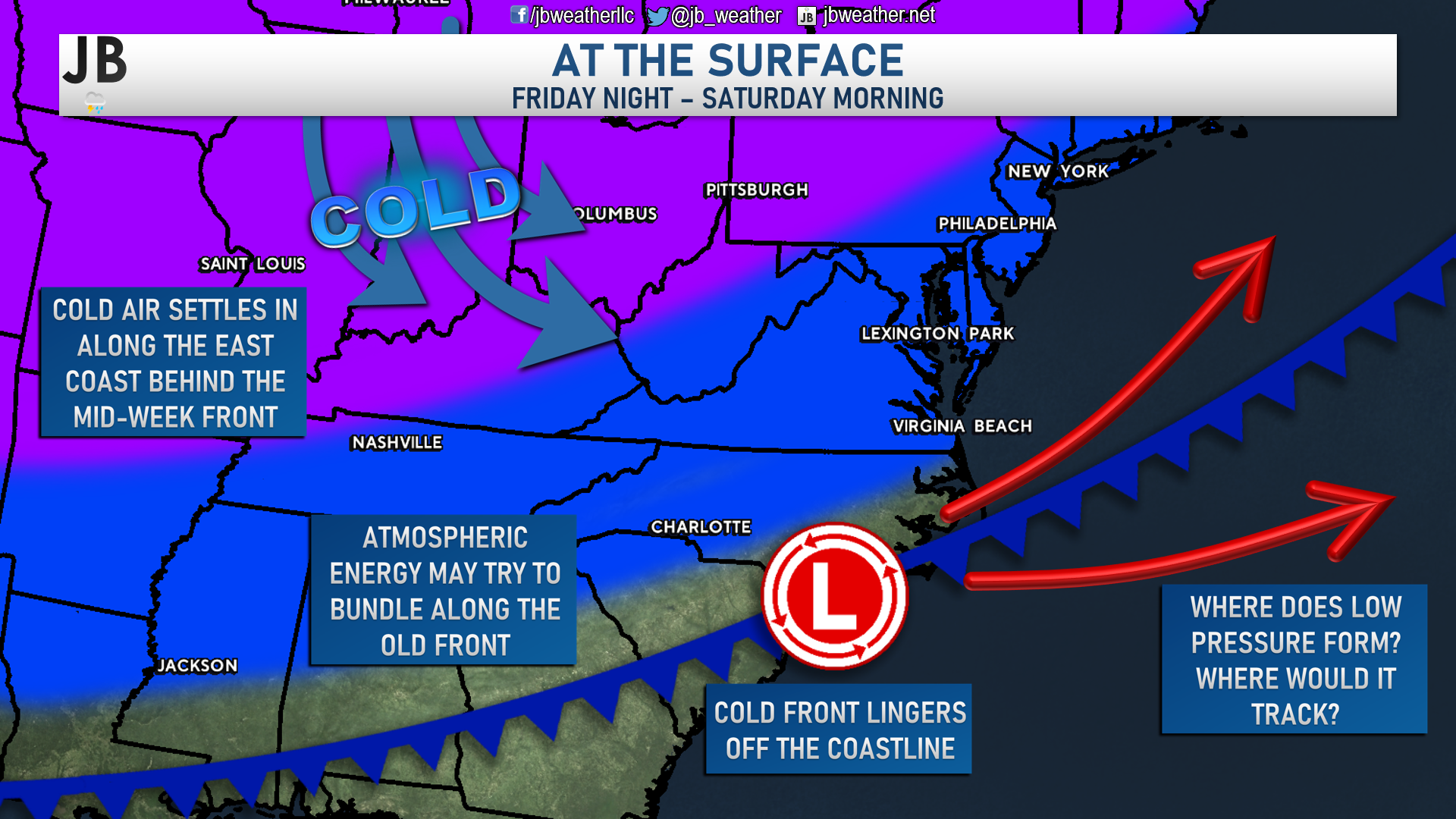
The cold front that is poised to move through the region Thursday morning will likely linger across the Southeast Friday, and into Saturday. We will see energy move along this dying frontal boundary. That energy will look to consolidate off the Carolina coastline into a storm system. The question I have had for the last few days is, “how far north will this track?” Our American model has not been very impressed with this system, taking it well to the southeast. The European model, on the other hand, has been more aggressive with taking it further north. Over the last day or so, we have seen the European model trend towards the American model, with a solution that is further southeast.
Timing
Precip will look to begin falling across the Carolinas and Southeast Virginia by midday Friday. With cold air filtering into the region, this will likely be snow across Virginia and northern parts of North Carolina, with more of an icy mix for southern Northern Carolina and parts of South Carolina. As the developing storm system begins to form, and push off the coastline, we will likely see the precip bump northward. How far northward can we get it to bump though? This model keeps the majority of the precip confined to Southeast VA and the Carolinas, placing our region right on the northern edge. If we were to see precip move through, it would likely be between sunset Friday and sunrise on Saturday. However, it does not look heavy, and would favor southern communities.
Forecast Maps
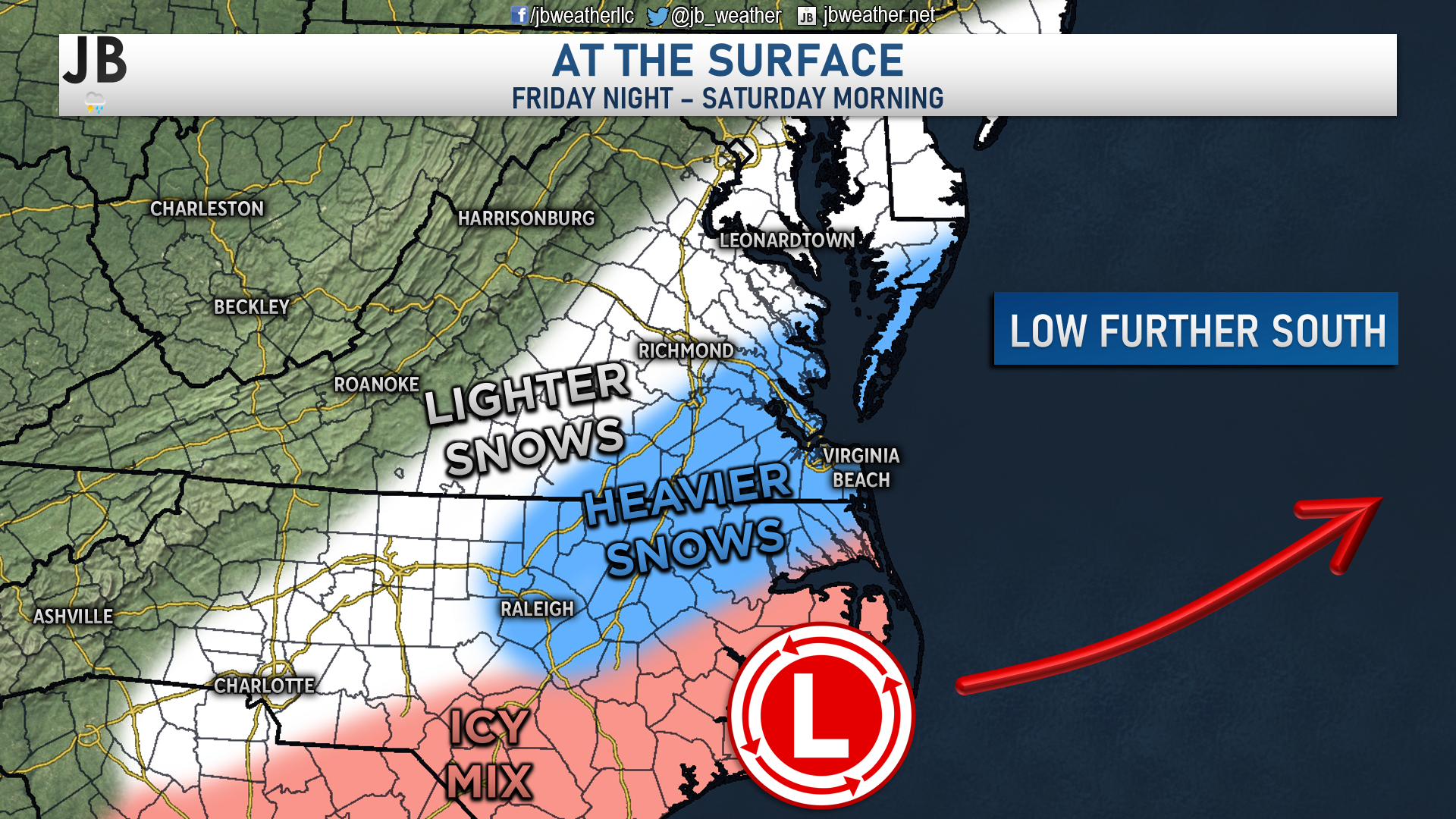
I do believe that this southern trend with this storm is correct. I think that the heavier snows will stay south of Richmond. I do think that we could see the precip shield expand just enough to get parts of southern Maryland and the Northern Neck in on some light snow. However, this would likely be a close call between some light snow and nothing at all.
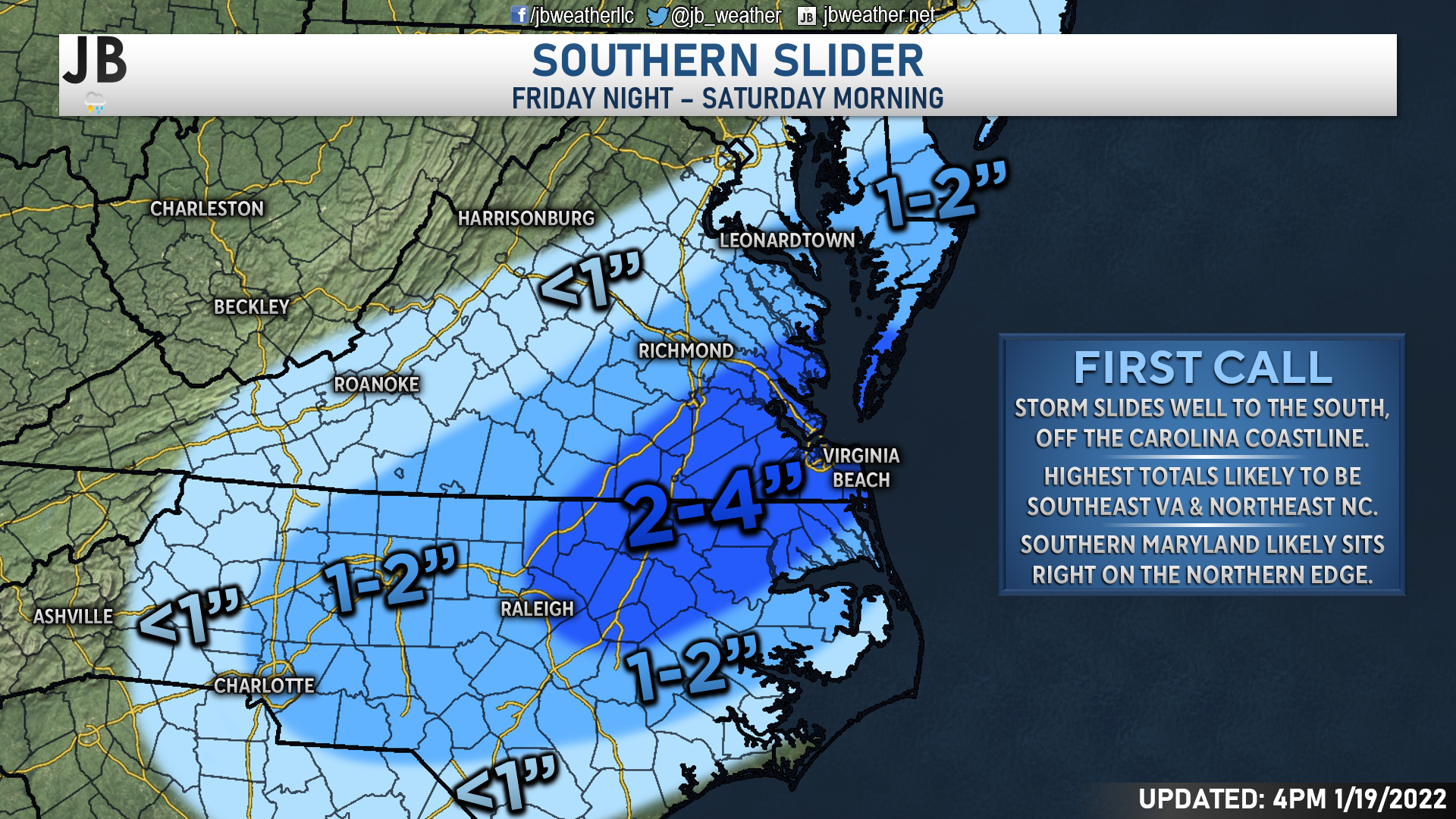
Right now, I believe that southeastern Virginia and northeastern North Carolina have the best chance to pick up several inches of snow from this system. This is where the precip is the most likely to be, and it could get moderate at times. Now, any northward or southward trend with this system and the cold front would have big implications on the forecast, and where the snow could potentially be centered.
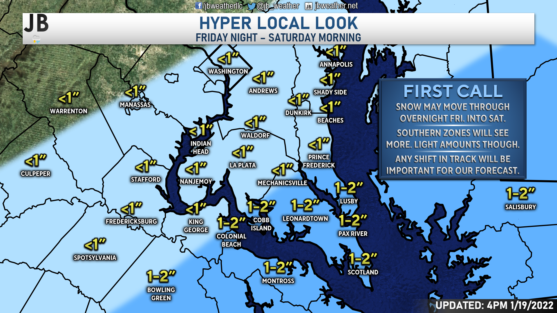
As I noted, Southern Maryland will be sitting right on the edge of this system. Communities south of Prince Frederick, Mechanicsville, and Colonial Beach will have the best chance to pick up an inch or two from this system. Areas northwest of that zone may not see much at all, likely under an inch. Again, any small shifts will alter this forecast greatly. There is a higher than normal chance that we see this system remain so far south that we may not see much.
Impacts
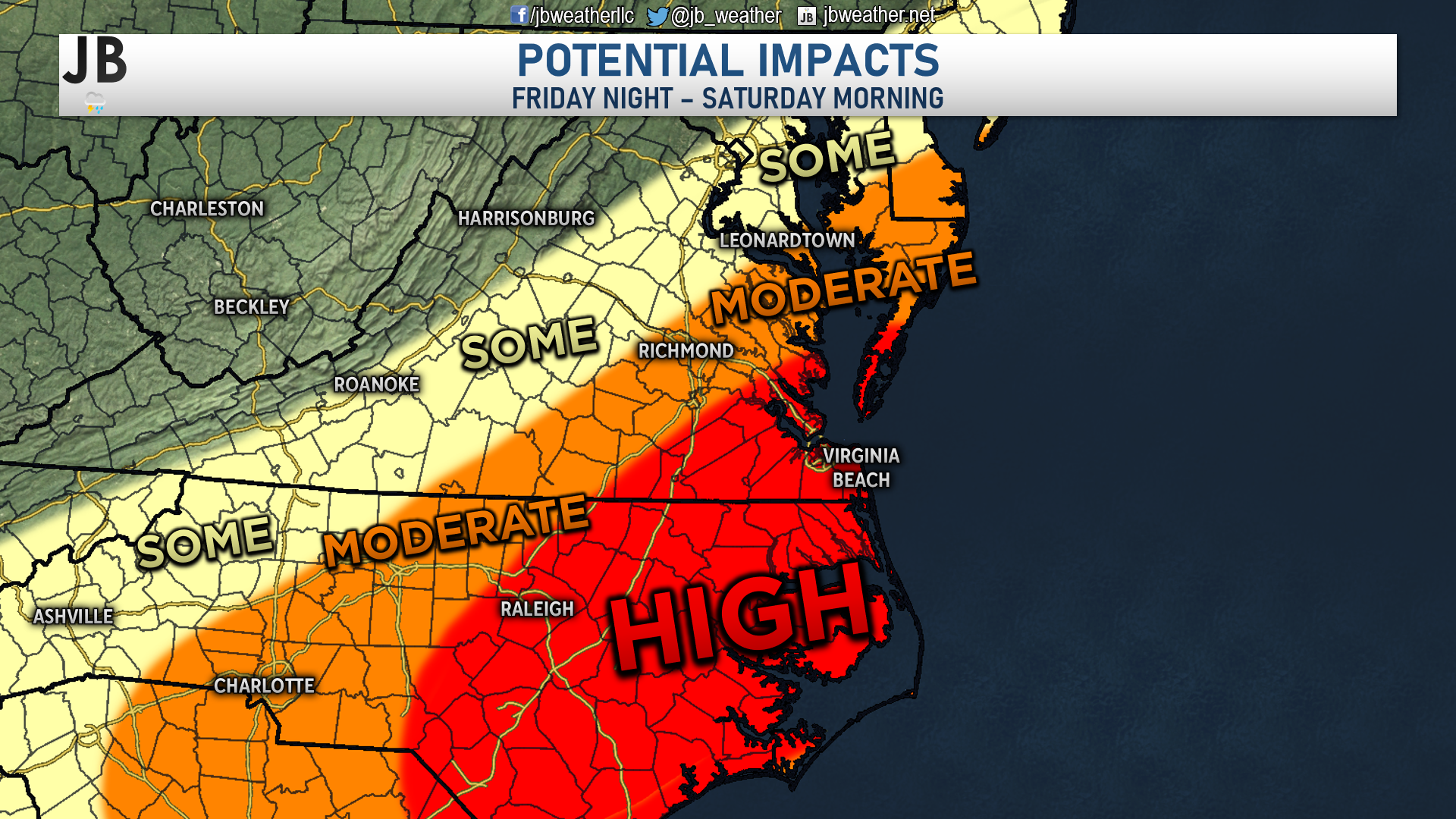
The highest impacts are likely to be felt across southeastern Virginia and northwestern North Carolina. This is where roadways and travel are likely to be the most impacted. Locally, we could see some travel impacts by Saturday morning, with souther communities potentially seeing more moderate impacts if the snow does indeed fall.
Storm FAQs
How confident are you in your forecast? My confidence with this forecast sits below average. There are some big questions about how far north the heaviest precip gets. Small shifts with the track will lead to big differences.
Where will the heaviest snow fall? The highest snow totals will be south of Richmond, closest to the area of the low pressure. Some spots near Virginia Beach may pick up several inches, with Southern MD likely being on the edge of snowfall and just conversational flakes.
When will the snow start? Current guidance shows that the snow may begin after sunset on Friday, close to midnight.
When will the heaviest snow fall? Likely during the predawn hours of Saturday. While I am not forecasting “heavy” snow per se, I would say that we could see some steady during this time, especially in southern St. Mary’s County.
When will the snow end? The snow should be winding down around sunrise on Saturday.
How much snow will I get at my house? Check out the accumulation map. Generally, I’m expecting less than an inch of snow across much of the region, but southernmost zones could see an inch or two from this system.
Could more or less snow fall than currently forecast? Absolutely. In order for more snow to happen, we would need the storm to track further northwest, which would allow heavy precipitation to develop over Southern MD. On the other hand, if the storm takes a slight jog to the south many areas will struggle to see much. In light of these plausible scenarios, here’s my assessment of snowfall probabilities:
20% chance: Nothing
40% chance: Coating to an inch
30% chance: 1-3″
10% chance: 3-6″+
As you can see, we have near equal chances of seeing nothing or of seeing a coating to 3″ of snow in our area. There is an outside chance that we see more than 3″, but I think that chance is very low.
Will the snow stick? If it does snow, I believe that it would stick. Temperatures on Thursday and Friday will be around/below freezing, allowing for the ground and road to be mighty cold.
Any chance of a wintry mix of freezing rain or sleet? The chances of that are very low with this storm. The southern storm track should keep the ice threat across the Carolinas
Summary
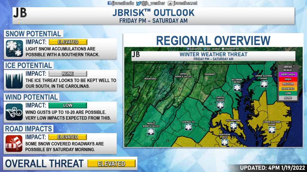
All in all, this does not look to be an overly big event Friday night into Saturday morning. We have a weak system sliding to our south as cold air filters into the region. Areas south of DC are the areas that could see snow out of this setup. Accumulation and impacts are possible across Southern MD Saturdaymorning. Right now, accumulation looks minor with only a few impacts. However, any shifts to the northwest with this storm would lead to higher totals and higher impacts.
Stay with JB Weather for the latest information on impacts here in Southern Maryland. You can always access my forecasts and updates here on the website, on Facebook, on Twitter, and on YouTube. JB Weather is Southern Maryland’s Weather Leader, and I am working around the clock to keep you ahead of any storm!
-JB

Gragan & Sons Glass Co., has been serving the Southern Maryland area since 1978. Contact them for all of your residential, commercial and automotive glass, they also specialize in CUSTOM glass shower enclosures & doors
John Bordash
View More PostsJB Weather forecaster John Bordash is working around the clock to provide Southern Maryland, and neighboring communities, with accurate and reliable weather information.

1 thought on “Looking Ahead: Light Snow Looks Possible Friday Night”
Comments are closed.
[…] [ January 19, 2022 ] Looking Ahead: Light Snow Looks Possible Friday Night Top Stories […]