Brought to you by Cedar Point Federal Credit Union
The last few days have featured wild swings in our weather! We’ve gone from the 70s last week, to rain and gusty winds with temps in the 40s/30s this weekend, just to go back into the 60s to kick off this week. Unfortunately, the wild swings will look to continue.
We have seen periods of rain move through the region today as a system passed to our northwest. While the rain has not been overly heavy, it is a definite change from yesterday’s amazing weather. We should see the rain showers get out of here overnight.
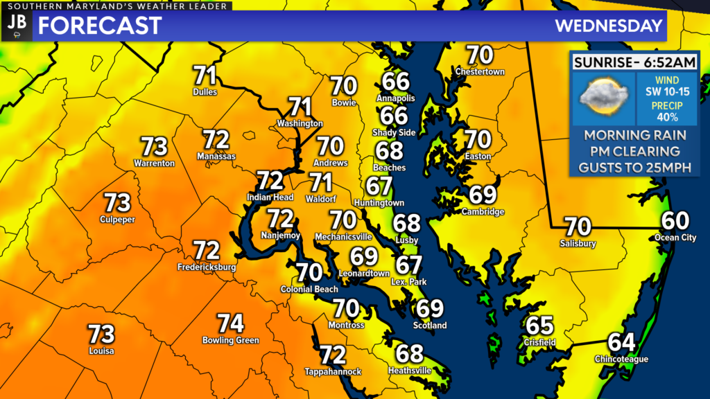
Southerly winds tomorrow will set Wednesday up as the warmest day this week! Much of the daylight hours tomorrow should be spent dry as temperatures surge into the 70s! You will want to make sure you get out and enjoy this nice weather because it will not be long-lived.
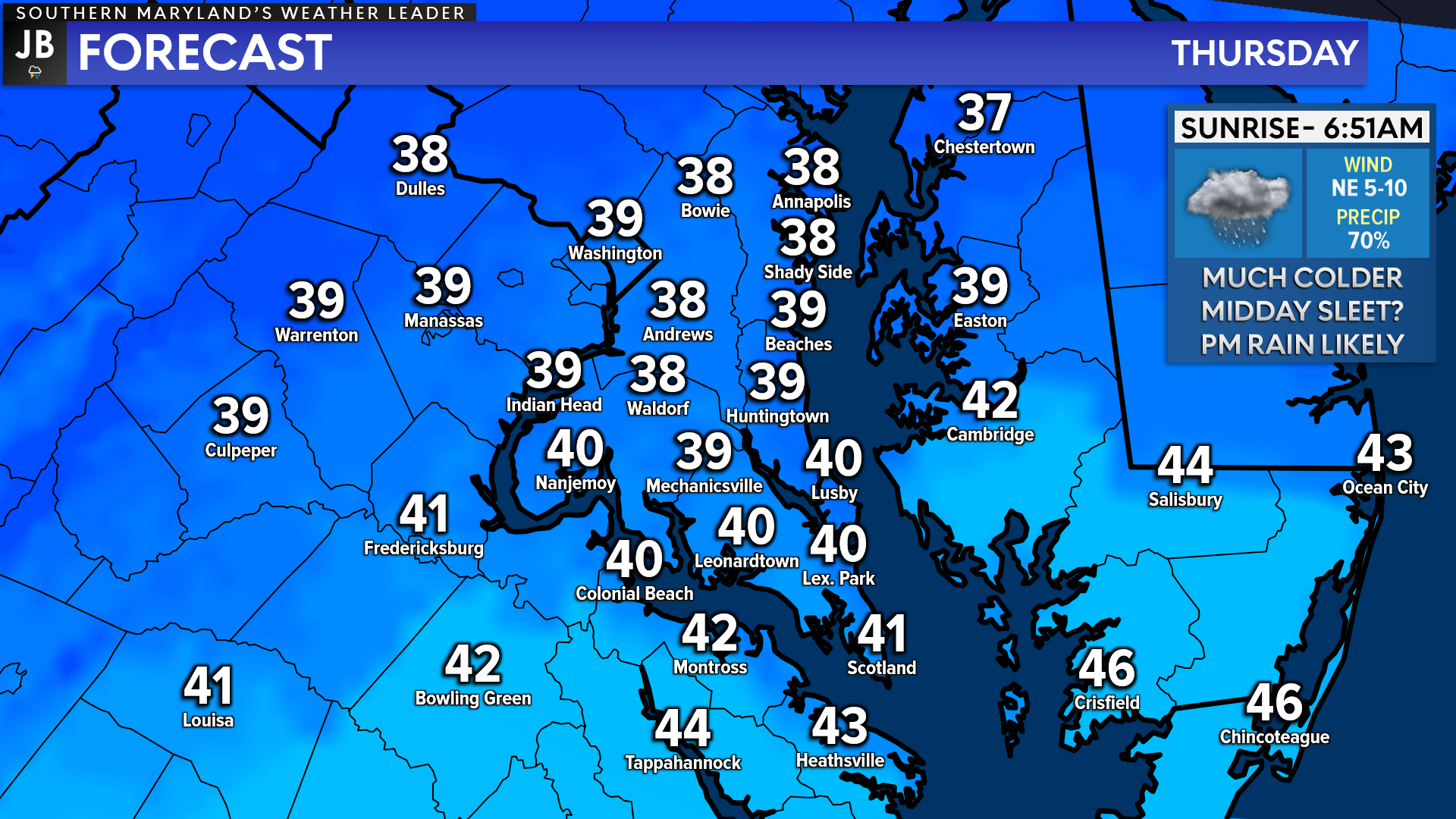
Colder air will work back into the region Wednesday night, thanks to a northerly flow. This will cool our temperatures by 30-40°! While Wednesday will feel like April, Thursday will feel a lot more like January, with highs likely only getting into the 30s/40s! This sets the stage for our next weather maker…
Another storm system will pass by the region on Thursday as the cold air filters into the region. As this system passes by the region, we will see moisture and warm air move northward. This complex setup could lead to a wintry mix across parts of the Mid-Atlantic on Thursday, before a changeover to all rain.
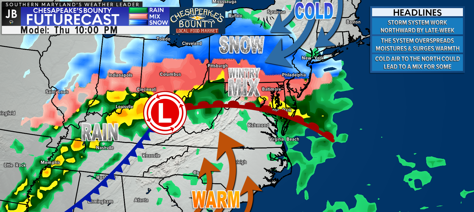
I believe that our long-range Chesapeake’s Bounty Futurecast model is doing a good job at depicting this potential set-up. The game we are playing on Thursday is to see how early the precip can get in here, and how cold temperatures will be. Our model has the precip moving in by midday with temperatures slowly warming into the upper 30s. If this were to happen, that would lead to just a cold rain south of DC, with any wintry mix being held to our north.
If the precip moves in quicker, or the air is colder, then we could see a period of icing be possible across much of the region. It is important to note that a few of our computer models do show that potential. With that said though, I am not sure I totally buy that solution. Nevertheless, this would not be a big ice storm.
We will see warm air surge northward throughout the day, which would switch any ice over to rain for Thursday night and Friday morning. We could see highs in the 50s on Friday as the rain pushes out, before another blast of cold air works in for the weekend.
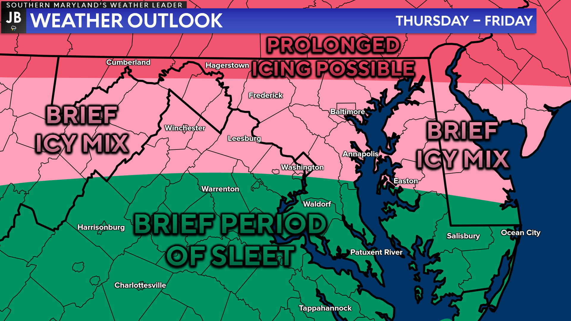
Right now, I do expect mainly a cold rain south of DC on Thursday. With that said though, we could see an hour or two of sleet initially. The warm temps on Wednesday should prevent us from seeing any high impacts. The time frame to watch for potential sleet is 10am-3pm. It is too early to say what, if any, impacts this would have on travel or schools. I suspect that it would be minor, but we will need to watch and see how this forecast changes.
The areas that will have a higher threat of icing will be north of DC, especially as you head towards the Mason Dixon Line. That is where several hours of icing is possible, which could lead to higher-end ice amounts. While Southern MD should transition over to rain easily, it will take longer for these northern areas.
Despite warming into the 50s on Friday, yet another blast of cold air will work in to kick off the weekend, cooling us back down in the 30s and 40s. A weak system may pass south of our region on Sunday, which will need to be watched, as it may try to interact with our cold air. It’s far too early to speculate too much on it, but it is something I will be watching.
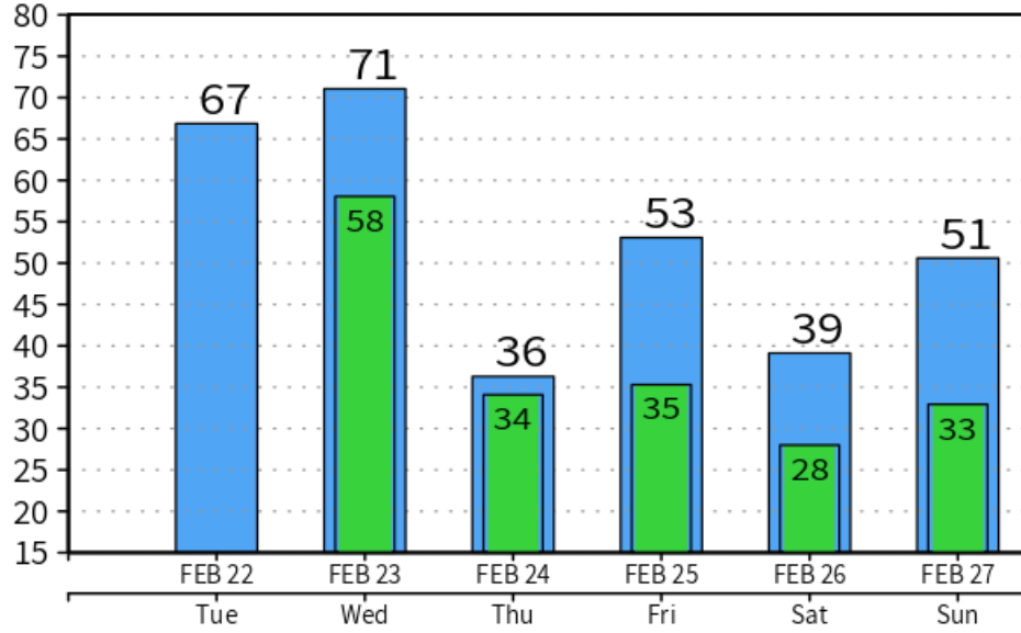
All-in-all, the rest of the weather week will remain very active! The image above is the high/low-temperature output from one of our models, which really does tell the story. We will see wild temperatures swings over the next few days. We could see a chance of sleet on Thursday before transitioning to all rain.
This is a forecast that you will want to stay updated on! This forecast is prone to change over the coming days. Make sure you check back for updates.
Stay with JB Weather for the latest information on Southern Maryland weather. You can always access my forecasts and updates here on the website, on Facebook, on Twitter, and on YouTube.
-JB
Cedar Point has been providing trusted banking, lending and personal finance solutions to the Southern Maryland Community since 1945. Visit the credit union at any of its 6 locations in St. Mary’s, Charles and Calvert counties or online at www.cpfcu.com.
John Bordash
View More PostsJB Weather forecaster John Bordash is working around the clock to provide Southern Maryland, and neighboring communities, with accurate and reliable weather information.
1 thought on “Our Streak of Active Weather Continues On…”
Comments are closed.
[…] [ February 22, 2022 ] Our Streak of Active Weather Continues On… Top Stories […]