Brought to you by Dugan, McKissick and Longmore, LLC
A weak front is slowly drifting southward towards our region today, which is helping to kick up some widely scattered storms to our northwest. We will see that front continue to drift southward tomorrow, and this should help to create more widespread chances for rain. The front will look to park itself just south of our region, across Central Virginia. This should bring decent rain chances to the Richmond and Virginia Beach areas. However, we could see that threat for rain and storms reach up into our region tomorrow afternoon and evening. Our Chesapeake’s Bounty Futurecast does a good job of depicting this potential.
The threat is there for widespread showers and storms, especially south of our region. If this front parks itself too far south, we likely won’t see much rain, and highs tomorrow will get into the lower to middle 90s. If this front parks itself further north we could see some decent rains, and our temperatures could be kept down in the 80s. With that said, the severe threat does not look overly high, but 1 or 2 strong storms are possible.
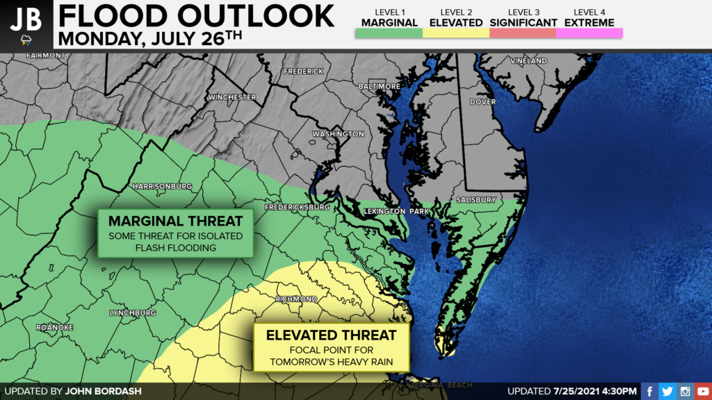
There will be plenty of moisture in the air for any potential thunderstorms to squeeze out tomorrow. We can measure this potential through a metric we call PWATs, or Precipitable Water values. This gives us an idea of how much water exists in the atmosphere, and how much rain could fall if perfect conditions existed. PWAT values in Central and Southern Virginia look to exceed 2″ with values across Southern Maryland looking to hang out in the 1-2″ range. The 1-2″ range is not abnormally high, but does suggest the potential for some heavy rain that could lead to localized flooding. Values over 2″ can suggest the potential for a more widespread flooding threat. With all of this in mind, the Weather Prediction Center has put southern parts of Charles, St. Mary’s, and Calvert Counties in a Level 1 Marginal Flood Threat. Areas to our south are under a Level 2 Elevated Flood Threat.

In Summary, I do not think that everyone will see rain tomorrow, and not everyone is guaranteed rain. However, we do have around a 50% chance of rain in Southern Maryland for tomorrow, with our southern communities really holding the best chance for rain. I think that a few scattered to widespread thunderstorms are possible. The main risk tomorrow will really come from an isolated flooding threat rather than a severe weather threat. The time frame to watch seems to be anytime after lunch tomorrow
Stay weather aware and stay with JB Weather for the latest information on Southern Maryland weather. You can always access my forecasts and updates here on the website, on Facebook, on Twitter, and on YouTube.
-JB

Dugan, McKissick & Longmore, LLC has served our Southern Maryland community for over 25 years. Our trusted attorneys are here to handle your unique case from beginning to end. To schedule an appointment, call us today at 301-862-3764 or visit our website at www.paxlawyers.com.

