Brought to you by Sonder Studios
Our forecast is coming into better focus as confidence grows that a significant coastal storm will develop and strengthen Sunday night. While some uncertainty remains in the exact storm track, accumulating snow and widespread impacts are increasingly likely across the region.
TIMING
Precipitation will begin moving into the region Sunday morning, with temperatures in the 30s and 40s. This will be mild enough for rain southeast of DC and a rain/snow mix northwest of DC at the start. Colder air will gradually work in through the afternoon, allowing snow to take over from northwest to southeast after lunch. Because of the marginal daytime temperatures and recent warmth, little accumulation is expected during the day.
The main snow and accumulation window still looks to be Sunday night into Monday morning as the coastal storm strengthens offshore.
FORECAST AMOUNTS
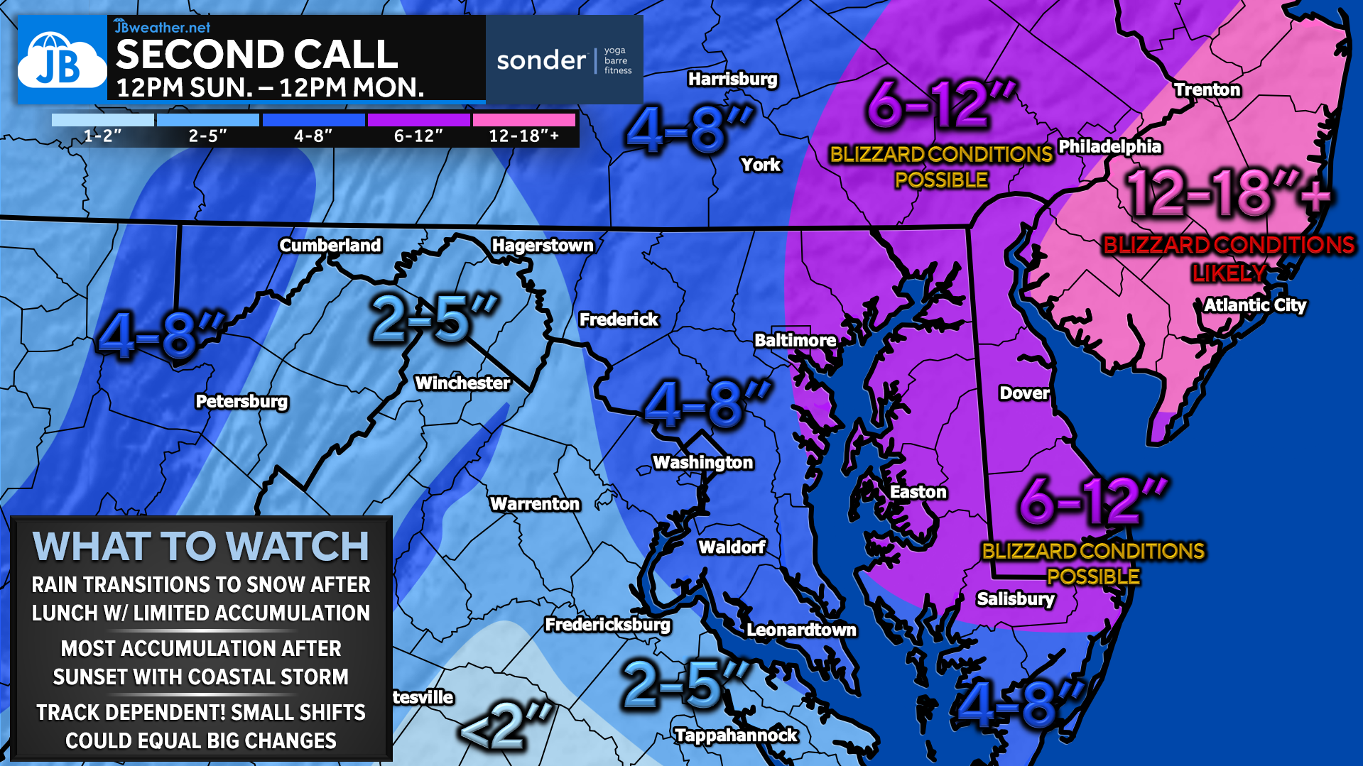
Most areas from southern Maryland through the DC and Baltimore corridor into southern Pennsylvania should see several inches of snow, with a general 4–8″ expected. While snow may fall during the day on Sunday, espically northwest of I-95, much of this will likely accumulate after sunset on Sunday.
Higher totals of 6–12″ are most likely east of the Bay and northeast toward Philadelphia, where the storm track will be closer. Along the Atlantic beaches, the combination of heavy snow and strong winds could push totals into the double digit,s with localized higher amounts possible. Blizzard conditions are possible along the coast, closest to the track of the storm!
IMPACTS
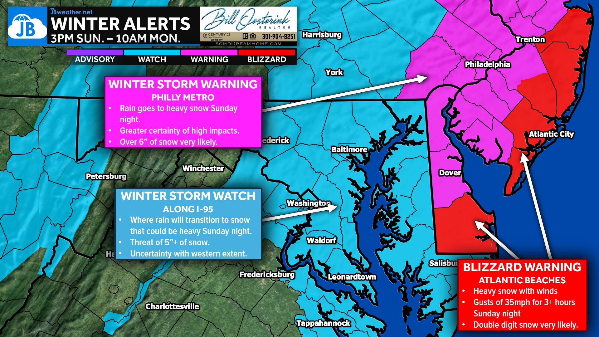
IMPACTS: Travel conditions are likely to deteriorate Sunday night as snowfall rates increase, with the greatest impacts expected into the Monday morning commute. Strong winds near the coast could lead to blowing snow and reduced visibility. Expect widespread impacts and closures Monday into Tuesday, especially where totals are highest.
KEY TAKEAWAYS
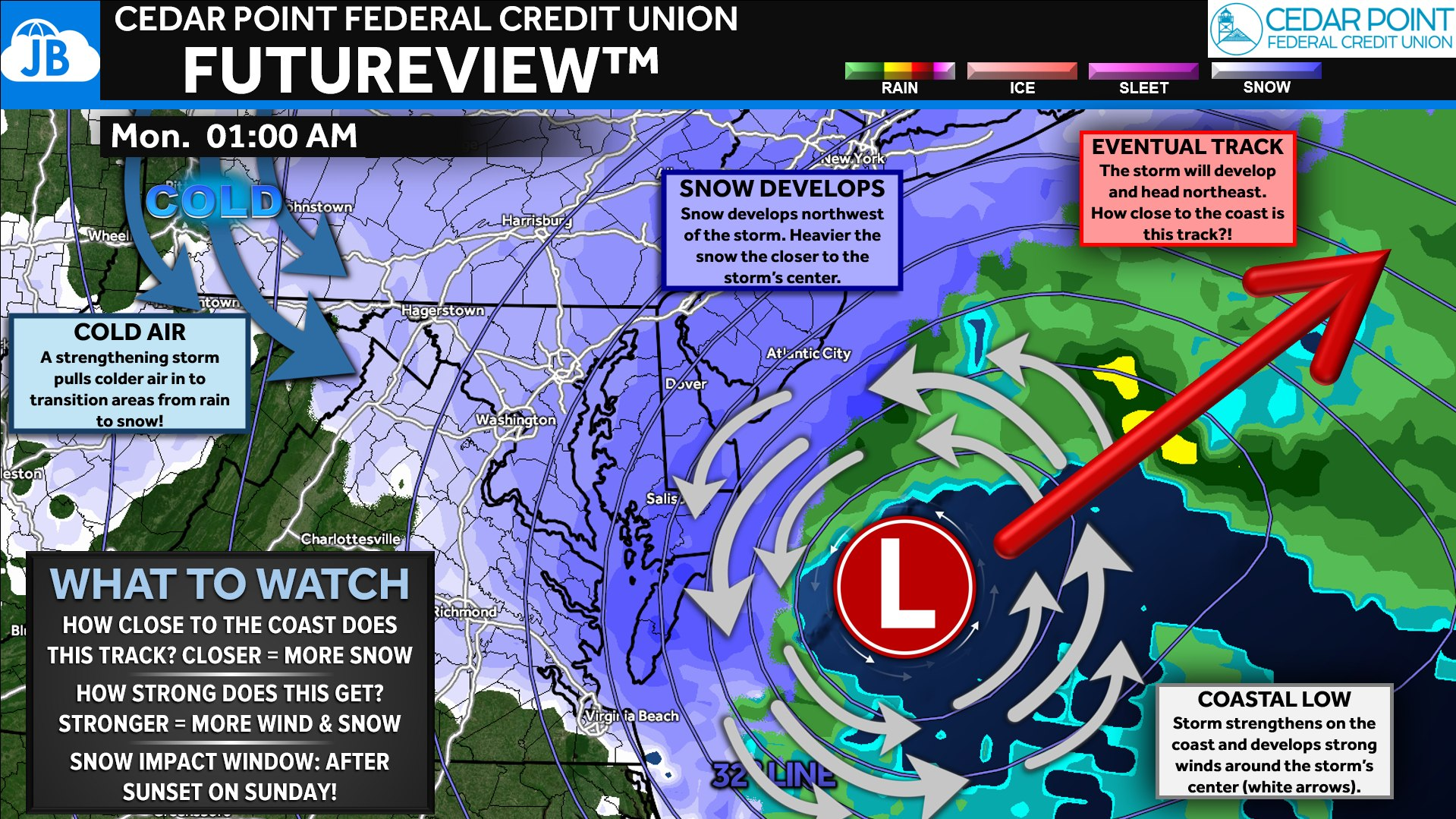
While confidence in accumulating snow is increasing, small shifts in the storm’s track could still change where the heaviest snow band sets up. It is possible that this could still shift 50–100 miles west or east — something we’ve seen before with storms like March 2017 and January 2015. I am very much on guard for that. With this in mind, additional adjustments to totals remain possible, and a rare third call may be needed tonight or tomorrow morning as new data arrives.
5-BULLET SUMMARY
🌧️ Rain or a mix to start Sunday before colder air flips most areas to snow after lunch
🌙 Heaviest snow expected Sunday night into Monday morning as the storm strengthens offshore
📍 4–8″ for the DC/Baltimore corridor, 6–12″ east of the Bay, higher along the coast
⚠️ Additional forecasts upgrades possible if the storm continues to trend west!
🚗 Travel impacts are likely on Monday with blowing snow near the coast and possible closures
Stay with JB Weather for the latest information on impacts here in Southern Maryland and across the Mid-Atlantic. You can always access my forecasts and updates here on the website, on Facebook, on Twitter, on Instagram, and on YouTube. JB Weather is the Mid-Atlantic’s Weather Leader, and I am working around the clock to keep you ahead of any storm!

SONDER℠ Yoga studio. Barre studio. Fitness Studio. Classes, events & education for being well. Sonder is a mindful community, and you are invited. 5+ years in Calvert County, MD. We are grateful for your trust.
John Bordash
View More PostsJB Weather forecaster John Bordash is working around the clock to provide Southern Maryland, and neighboring communities, with accurate and reliable weather information.