After a relatively quiet weekend, attention now turns to a strengthening storm system that will move from the Ohio Valley into the Northeast on Monday. The Storm Prediction Center continues to place much of the Mid-Atlantic under an Elevated Risk (Level 2 of 5) for severe weather, with damaging winds expected to be the primary threat.
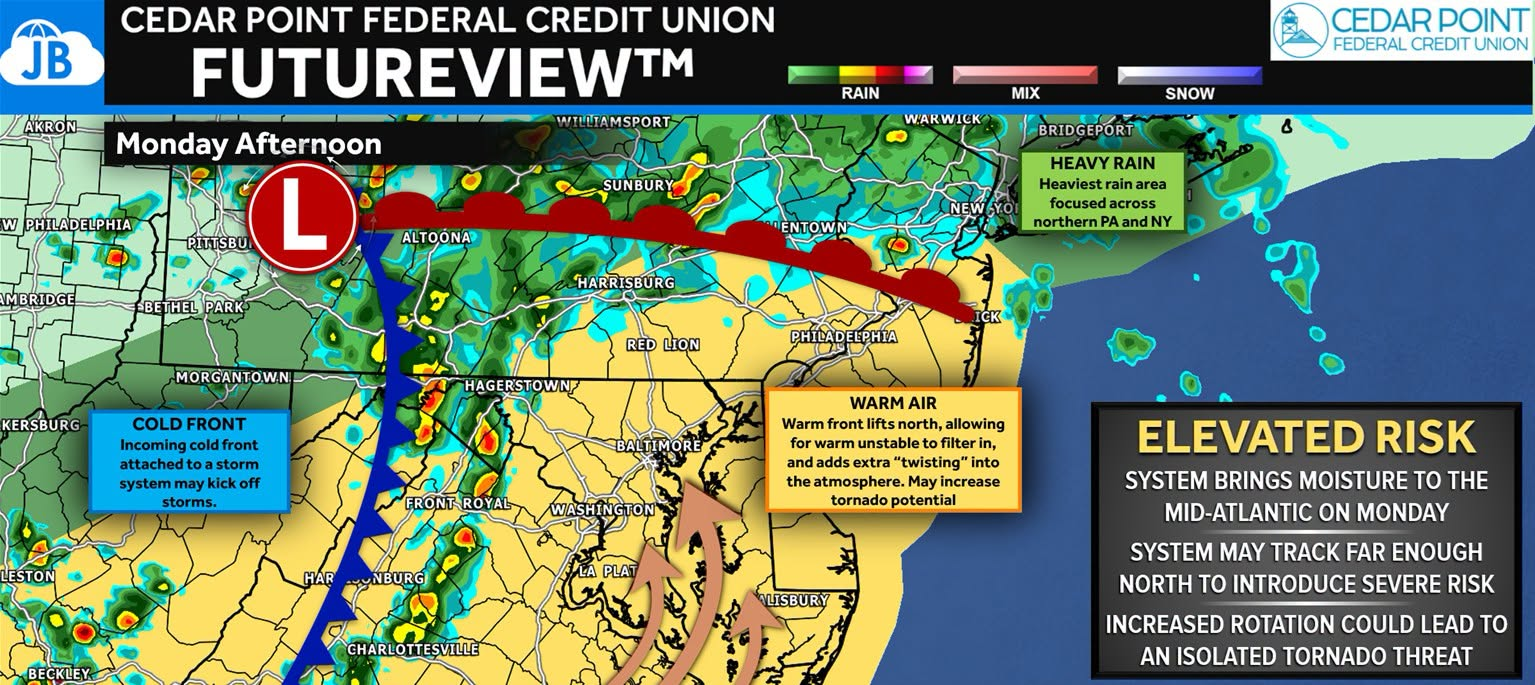
While this is not a classic severe weather setup, it is one that deserves attention. The combination of a northward-moving warm front, increasing wind shear, and abundant moisture could support strong to severe thunderstorms Monday afternoon and evening.
Why This Setup Has Our Attention
The same storm system currently producing severe weather across portions of the Midwest will be moving into our region on Monday. As it approaches, a warm front will lift northward through the Mid-Atlantic, allowing warm, humid air to spread into the area.
Warm fronts are often areas where the atmosphere can develop additional low-level rotation. While not every warm-front setup produces tornadoes, these boundaries can create localized zones where thunderstorms become more organized and capable of rotating.
This is one reason I am keeping a close eye on the potential for isolated tornadoes, particularly near and south of wherever the warm front ultimately sets up.
Main Threats
🌬️ Damaging Winds: Damaging straight-line winds remain the greatest concern. Increasing wind shear and high moisture levels could allow storms to organize into clusters capable of producing strong wind gusts that may bring down trees and power lines.
🌪️ Isolated Tornadoes: An isolated tornado threat exists across parts of the region. The risk appears conditional and will depend heavily on how much instability develops and where the warm front is positioned during the afternoon. While widespread tornado activity is not expected, this is a threat that cannot be ignored.
🌧️ Heavy Rain & Localized Flooding: The atmosphere will contain plenty of moisture, with precipitable water values approaching tropical levels. Some forecast guidance suggests multiple rounds of thunderstorms may occur, which could lead to localized flooding, especially in poor-drainage and urban areas.
Timing
Morning: Periods of showers and a few thunderstorms are possible, especially across Pennsylvania and areas north of the region.
Afternoon: The warm front lifts northward and instability increases. Thunderstorms begin developing and intensifying.
Afternoon Into Evening: Highest risk for severe weather, including damaging winds, heavy rainfall, and isolated tornadoes.
Understanding the Tornado Threat
While damaging winds remain the primary concern Monday, an isolated tornado threat does exist. The graphic below shows where the Nadocast Tornado Forecast believes atmospheric conditions may be most favorable for tornado development. Notice the corridor extending from the Delmarva into New Jersey, which closely matches where we expect the warm front to be located.
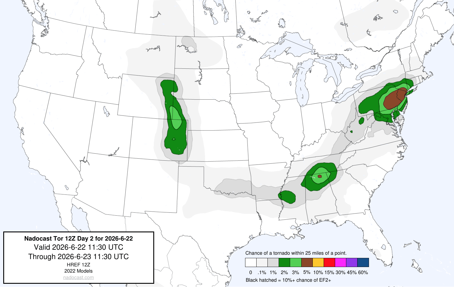
This does not mean tornadoes are expected everywhere in the shaded area. Instead, it highlights where a few storms could rotate if enough instability develops.
At this time, the tornado threat appears isolated, but it is something we’ll be watching closely as the warm front lifts north through the region Monday afternoon.
Forecast Challenges
The biggest uncertainty remains how the atmosphere recovers from any morning rainfall and exactly where the warm front sets up during the afternoon. Small shifts in the front’s position could significantly impact where the strongest storms develop.
That means not everyone will see severe weather, but those who do could experience rapidly changing conditions.
Bottom Line
Monday is shaping up to be an active weather day across the Mid-Atlantic. Damaging winds remain the primary concern, but the combination of a warm front, increasing wind shear, and abundant moisture means isolated tornadoes and localized flooding are also possible.
This is not expected to be a major outbreak, but it is one of those setups where subtle changes can make a big difference. We’ll be monitoring trends closely throughout the day and providing updates as confidence increases.
Quick Takeaways
⚠️ Strong to severe thunderstorms are possible Monday afternoon and evening.
🌬️ Damaging winds are the primary threat.
🌪️ Isolated tornadoes cannot be ruled out, especially near the warm front.
🌧️ Heavy rainfall may lead to localized flooding.
📍 The position of the warm front will likely determine where the greatest severe weather risk develops.
Stay with JB Weather for the latest information on impacts here in Southern Maryland and across the Mid-Atlantic. You can always access my forecasts and updates here on the website, on Facebook, on Twitter, on Instagram, and on YouTube. JB Weather is the Mid-Atlantic’s Weather Leader, and I am working around the clock to keep you ahead of any storm!
John Bordash
View More PostsJB Weather forecaster John Bordash is working around the clock to provide Southern Maryland, and neighboring communities, with accurate and reliable weather information.