Brought to you by G&H Jewelers, Inc.
Light to occasionally moderate snow has continued this afternoon as our snowstorm finally moves out. We have seen the snow and gusty winds work together to create near impossible driving conditions and widespread power outages. SMECO has been working hard to reconnect customers without power, but these conditions are working against them. At one point, we were averaging 1 out of every 4 SMECO customers being without power.
Since early this morning, many spots have recorded between 6-12″ of heavy snow. I will have a full forecast review with a map of actual snow totals published later, but here is a look at some of the snow totals that have been reported by the National Weather Service:
- 2 SSE Glendie [Stafford Co, VA]: 14.6″
- 4 ESE Chancellorsville [Spotsylvania Co, VA]: 14.5″
- 2 SSW Dunkirk [Calvert Co, MD]: 13.0″
- 1 ENE Churchton [Anne Arundel Co, MD]: 12.5″
- 1 WSW Marlton [Prince Georges Co, MD]: 11.5″
- 2 WNW Welcome [Charles Co, MD]: 10.5″
- 3 ENE LA Plata [Charles Co, MD]: 10.2″
- 1 SW Huntingtown [Calvert Co, MD]: 10.1″
- 2 ENE Hughesville [Charles Co, MD]: 10.0″
- Prince Frederick [Calvert Co, MD]: 10.0″
- 1 SW Dentsville [Charles Co, MD]: 10.0″
- Odenton Anne Arundel Co, MD]: 8.5″
- 2 W Callaway [St. Marys Co, MD]: 6.5″
- 1 NNE Park Hall [St. Marys Co, MD]: 6.0″
- 1 SSE Leonardtown [St. Marys Co, MD]: 6.0″
You can submit your totals to JB Weather by filling out the form below:
Light snow is pulling out of the region this afternoon, and we will be left with mainly clear skies as head into tonight. Tonight we’ll end up with the coldest temperatures of the season to date. Lows range from the middle teens to lower 20s regionwide. While winds will gradually calm down throughout the afternoon and evening, we will still be with some stiff NW breezes tonight, up to 25mph.
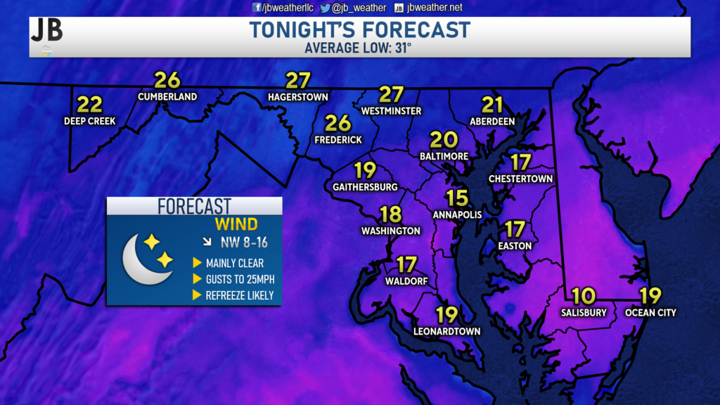
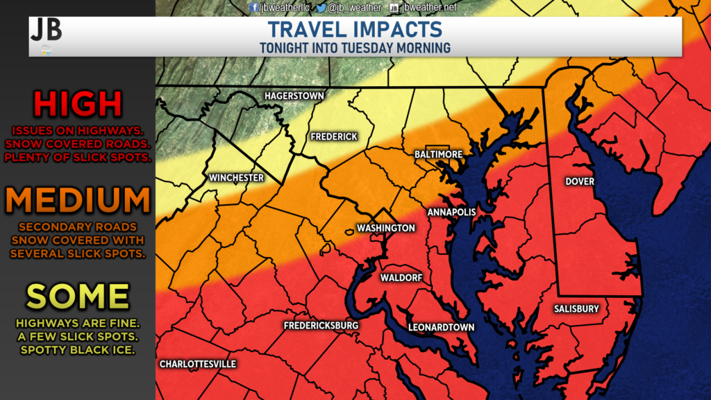
These cold temperatures will allow not allow for our snow to melt overnight and will cause any currently wet or slushy spots to freeze up. I would expect high travel impacts to linger into tonight and for tomorrow morning’s commute. Area highways will likely still have some snow on them with secondary & back roads remaining snow-covered. Slick spots and black ice will be plentiful as well. Road conditions will improve as you head to the northwest, as those regions saw far less snow than we did.
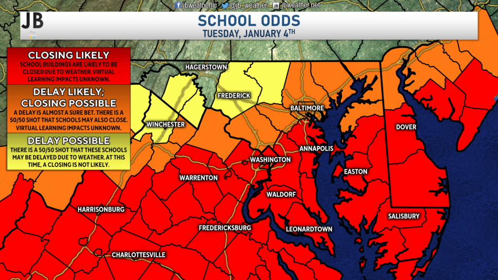
It is because of these high travel impacts that I expect school buildings to closed throughout our local region, as well as for many schools south of DC. School districts just north of DC that did see some snow today are likely to delay tomorrow due to slick travel conditions and may end closing too. School systems well to the northwest have a 50/50 shot of a delay, but a closing looks unlikely there. Stay in contact with your local school district about the policies and procedures that would be in play during a 2-hour delay or closing, and if that would lead to virtual learning instead (unfortunately, I do not have all of those answers).
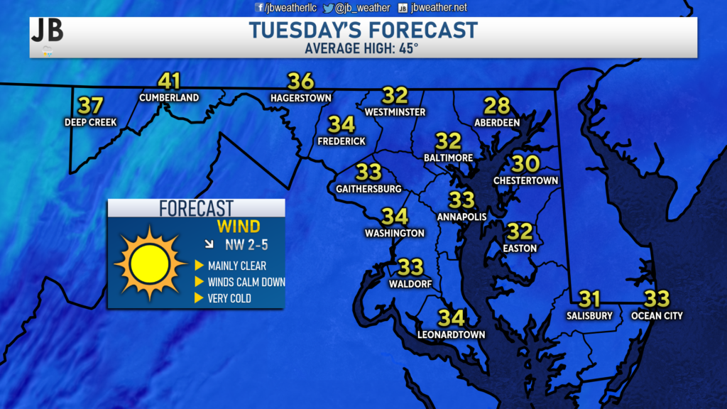
Highs tomorrow will only look to max out in the lower to middle 30s, barely getting above freezing. This will not help melt a lot of the snow we saw today. However, the clear conditions and calm winds will allow for snowplows to get out there and do their thing. The calm winds will also allow for power crews to get out there and work on restoring power too. Do keep in mind that every night this week has a low below freezing, so another refreeze could be in play for Wednesday morning as well.
What a storm it has been for snow lovers, full of heavy snow and over-performing totals! It sure has been a busy day in the weather center. Thank you for staying with JB Weather throughout the day on the website, on Facebook, on Twitter, and on YouTube. JB Weather is Southern Maryland’s Weather Leader, and I am working around the clock to keep you ahead of any storm! I will continue to have coverage throughout the cleanup process of this storm.
-JB

Shop G&H Jewelers Today for Loose Diamonds, Fine Diamond & Colored Gemstone Jewelry, On-site Custom Jewelry Design (CAD) & Manufacturing, Jewelry Repair and GIA Graduate Gemologist Appraisal Services. Third Generation Family Owned & Operated Since 1965.

