Brought to you by Sonder Studios
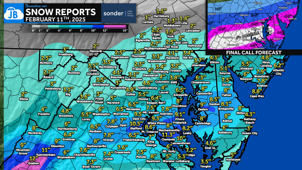
For the most part, I am very pleased with the way that this forecast worked out. Almost all areas fell within their projected ranges per my final call forecast. We did indeed see that band of 6″+ develop from Central VA to Southern MD. 4″+ fell south of Baltimore with that 2″ line making it to York, PA. I try to be modest, but I would rate this forecast darn near an A. While it was impactful, the snow from this storm will not stick around long.
********************STORM TOTAL SNOWFALL********************

LOCATION                TOTAL      TIME/DATE  COMMENTS
                     SNOWFALL       MEASURED
                     (inches)
...Anne Arundel County...
  Cape St. Claire         8.0   552 AM  2/12  Trained Spotter
  Churchton  ENE          8.0   700 AM  2/12  Trained Spotter
  Londontowne 1 SSE       7.0   739 AM  2/12  NWS Employee
  Londontowne 3 SW        6.5   707 AM  2/12  CoCoRaHS
  Annapolis 1 S           6.5   800 AM  2/12  Trained Spotter
  Eastport 1 SSW          6.5   730 AM  2/12  Trained Spotter
  Crownsville 3 SSW       6.2   700 AM  2/12  Trained Spotter
  Parole                  6.0   800 AM  2/12  Dept of Highways
  Riva 2 WNW              6.0   800 AM  2/12  Trained Spotter
  Crofton 2 NNE           5.5   700 AM  2/12  NWS Employee
  Crofton 1 SSE           5.1   817 AM  2/12  NWS Employee
  Chelsea Beach           4.8   315 AM  2/12  Trained Spotter
  Cape St. Claire 3 SE    4.5   800 AM  2/12  Dept of Highways
  Baltmore-Washington     4.0   800 AM  2/12  Dept of Highways
  Green Haven 1 ESE       4.0   600 AM  2/12  Trained Spotter
  Bwi Airport             3.8   700 AM  2/12  Official NWS Obs
...Baltimore County...
  Edgemere  SE            4.9   730 AM  2/12  Trained Spotter
  Bentley Springs 6 S     4.1   800 AM  2/12  Dept of Highways
  North Point State Pa    4.0   645 AM  2/12  Trained Spotter
  Rosedale 1 E            3.8   800 AM  2/12  Dept of Highways
  White Marsh 2 E         3.7   600 AM  2/12  Trained Spotter
  Owings Mills            3.6   800 AM  2/12  Dept of Highways
  Randallstown 2 NW       3.5   914 AM  2/12  Trained Spotter
  Perry Hall 1 NNE        3.5   758 AM  2/12  Trained Spotter
  Fullerton 1 N           3.5   900 AM  2/12  Trained Spotter
  Timonium                3.4   213 AM  2/12  Public
  Glyndon 1 WSW           3.3   451 AM  2/12  Trained Spotter
  Upper Falls 1 NNE       3.3   530 AM  2/12  Trained Spotter
  Hampton 1 NE            3.2   729 AM  2/12  Public
  Long Green 2 NW         3.0   600 AM  2/12  Trained Spotter
  Cockeysville 1 N        2.5   113 AM  2/12  Broadcast Media
  Bentley Springs 1 E     2.3   600 AM  2/12  Trained Spotter
...Calvert County...
  Huntingtown  SW         9.3   650 AM  2/12  Trained Spotter
  Prince Frederick 1 S    9.1   430 AM  2/12  Trained Spotter
  Dowell 2 NE             8.2   630 AM  2/12  Trained Spotter
...Charles County...
  Waldorf 2 W             8.8   610 AM  2/12  Trained Spotter
  Dentsville 1 SW         8.7   130 AM  2/12  Trained Spotter
  La Plata 3 E            8.1   646 AM  2/12  Public
  La Plata 2 NNW          8.0   800 AM  2/12  Dept of Highways
  Charlotte Hall 2 NW     7.5   600 AM  2/12  Trained Spotter
  Welcome 2 WNW           7.2   700 AM  2/12  Trained Spotter
  Wicomico 2 N            7.0   720 AM  2/12  Public
  Dahlgren 5 ENE          5.5   800 AM  2/12  Dept of Highways
...Prince Georges County...
  Andrews Afb 2 E         7.8   900 AM  2/12  Trained Spotter
  Marlton 1 WSW           7.0   730 AM  2/12  Trained Spotter
  New Carrollton 1 E      5.4   131 AM  2/12  Public
  Upper Marlboro 1 S      5.3   800 AM  2/12  Dept of Highways
  College Park 1 S        4.7   900 AM  2/12  Trained Spotter
  Laurel 1 E              4.0   800 AM  2/12  Dept of Highways
...St. Marys County...
  Clements 3 E           11.3   800 AM  2/12  Dept of Highways
  Callaway 2 W            8.0   345 AM  2/12  Trained Spotter
  Ridge 1 ENE             7.2   700 AM  2/12  Trained Spotter
  California 1 E          7.0  1100 AM  2/12  Trained Spotter
  California 3 W          6.8   745 AM  2/12  Trained Spotter
VIRGINIA
...King George County...
  King George 1 NE        7.0   400 AM  2/12  Trained Spotter
...Northumberland County...
3 ESE Howland                6.0 in    0700 AM 02/12   37.86N/76.41W
Lottsburg                    5.3 in    0643 PM 02/11   37.96N/76.52W
Edwardsville                 5.0 in    0611 PM 02/11   37.91N/76.36W
...Prince William County...
  Lake Ridge 1 SW         8.5   430 AM  2/12  Trained Spotter
  Independent Hill 3 N    8.4   500 AM  2/12  Trained Spotter
  Dale City 1 W           8.3   730 AM  2/12  Trained Spotter
  Dumfries 1 ENE          7.8   140 AM  2/12  Trained Spotter
  Woolsey 1 SW            6.0   735 AM  2/12  Trained Spotter
  Woolsey 2 W             5.4   639 AM  2/12  Public
  Woolsey 2 SSW           5.2   504 AM  2/12  Trained Spotter
…Richmond County…
Warsaw 6.0 in 0546 PM 02/11 37.96N/76.76W
Kennard 5.5 in 0734 PM 02/11 37.92N/76.75W
Emmerton 4.5 in 0540 PM 02/11 37.90N/76.68W
...Spotsylvania County...
  White Oak 4 SSW         6.4   723 AM  2/12  Trained Spotter
  Spotsylvania Courtho    6.0  1113 AM  2/12  Trained Spotter
  Spotsylvania Courtho    5.3   900 AM  2/12  Trained Spotter

...Stafford County...
  Glendie 1 N             8.6   627 AM  2/12  Trained Spotter
  Falmouth 3 NW           8.5   815 AM  2/12  Trained Spotter
  Holly Corner 2 E        8.0   700 AM  2/12  Trained Spotter
  Ramoth 1 W              7.8   715 AM  2/12  Trained Spotter
  Brooke 1 ESE            7.5  1130 AM  2/12  Trained Spotter
  Holly Corner 1 ENE      7.5   815 AM  2/12  NWS Employee
  Arkendale 2 WNW         7.0   720 AM  2/12  Trained Spotter


...Westmoreland County...
Mount Holly                  6.0 in    0543 PM 02/11   38.09N/76.72W
1 NW Montross                4.2 in    0621 PM 02/11   38.10N/76.83W
Montross                     4.0 in    0531 PM 02/11   38.09N/76.82W
Stay with JB Weather for the latest information on impacts here in Southern Maryland and across the Mid-Atlantic. You can always access my forecasts and updates here on the website, on Facebook, on Twitter, on Instagram, and on YouTube. JB Weather is the Mid-Atlantic’s Weather Leader, and I am working around the clock to keep you ahead of any storm!

SONDER℠ Yoga studio. Barre studio. Fitness Studio. Classes, events & education for being well. Sonder is a mindful community, and you are invited. 5+ years in Calvert County, MD. We are grateful for your trust. Check out sonderstudios.us!
John Bordash
View More PostsJB Weather forecaster John Bordash is working around the clock to provide Southern Maryland, and neighboring communities, with accurate and reliable weather information.