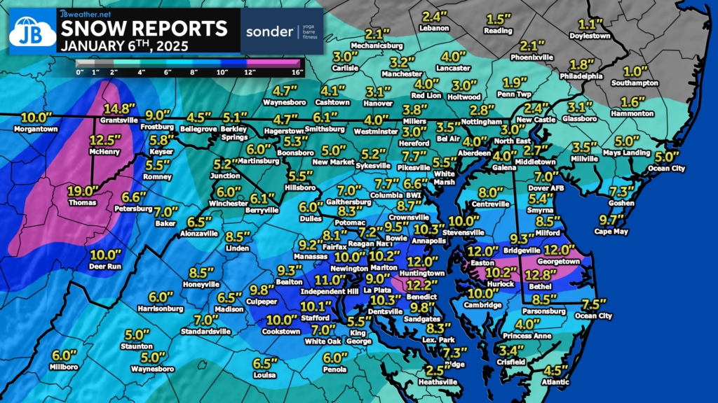
On Monday, we saw widespread heavy snow impact much of the Mid-Atlantic. This wasn’t an easy storm to predict with so many variables at play. My forecast was for 6-10″ of snow through the DC area with 4-8″ in Northern MD and Southern MD. At the end of the day, we saw northern zones stay on the lower side of my forecast and southern zones stay on the higher side of my forecast (and in some spots, they greatly performed)! This is thanks to less sleet in southern zones and the heavy snow band focusing south instead of north. All in all, I would grade my forecast a B-.
Below is a look at our general snow totals

********************STORM TOTAL SNOWFALL********************

LOCATION                TOTAL      TIME/DATE  COMMENTS
                  SNOWFALL       MEASURED (inches)

DISTRICT OF COLUMBIA

...District of Columbia...
Washington 3 NE         8.3   700 AM  1/07  CoCoRaHS
Anacostia 1 N           7.7   343 PM  1/06  Public
Washington 1 E          6.8  1000 PM  1/06  Trained Spotter
Anacostia SSE           6.5   515 PM  1/06  Trained Spotter
Adams Morgan 1 SSE      6.5   730 PM  1/06  Trained Spotter
Anacostia 1 S           6.5   930 PM  1/06  Trained Spotter
American University     6.3  1224 PM  1/06  Broadcast Media


MARYLAND

...Anne Arundel County...
Londontowne 1 SSE      10.3  1130 PM  1/06  NWS Employee
Crownsville 3 SSW       9.7   700 AM  1/07  Trained Spotter
Galesville 1 W          9.5   908 AM  1/07  NWS Employee
Annapolis 2 SW          9.5   445 PM  1/06  NWS Employee
Annapolis 1 S           9.2   630 AM  1/07  Trained Spotter
Birdsville WSW          9.1   700 AM  1/07  CoCoRaHS
Birdsville              9.1  1200 AM  1/07  NWS Employee
Severn 2 SSW            9.0   821 AM  1/07  CoCoRaHS
Parole 2 NE             9.0   700 AM  1/07  Trained Spotter
Annapolis 1 SE          9.0   815 AM  1/07  CoCoRaHS
Deale 1 SE              9.0   700 AM  1/07  CoCoRaHS
Annapolis 2 S           8.5   445 PM  1/06  NWS Employee
Cape St. Claire         8.3  1150 AM  1/06  Trained Spotter
Crofton 2 NNE           7.9   700 AM  1/07  NWS Employee
Crofton 1 SSE           7.8   700 AM  1/07  CoCoRaHS
Green Haven 1 ESE       7.5   615 AM  1/07  Trained Spotter
Churchton ENE           7.5   130 PM  1/06  Trained Spotter
Riva 1 NE               7.5   411 PM  1/06  Public
Hillsmere Shores 1 N    7.4   404 PM  1/06  Trained Spotter
Chelsea Beach           7.4  1100 PM  1/06  Trained Spotter
Pasadena 1 ENE          7.3   905 PM  1/06  Trained Spotter
Parole                  7.2   500 PM  1/06  Dept of Highways
Odenton 1 S             7.2  1100 AM  1/06  Trained Spotter
Baltmore-Washington     7.0   500 PM  1/06  Dept of Highways
Odenton 1 WNW           7.0   145 PM  1/06  Trained Spotter
Bwi Airport             6.6   100 AM  1/07  Official NWS Obs
Glen Burnie 1 WSW       6.1  1004 PM  1/06  Trained Spotter

...Calvert County...
Benedict 1 E           12.2   827 PM  1/06  Public
Huntingtown  SW        12.1  1115 PM  1/06  Trained Spotter
Chesapeake Beach       12.0   445 PM  1/06  NWS Employee
Prince Frederick 1 S   11.6  1010 PM  1/06  Trained Spotter
Huntingtown 3 NNW      11.0   700 AM  1/07  CoCoRaHS
North Beach 1 W        10.8  1230 PM  1/06  Trained Spotter
Prince Frederick 1 W   10.3   800 AM  1/07  CoCoRaHS
Huntingtown 3 SSW      10.0  1158 AM  1/06  Trained Spotter
Dunkirk 3.2NNE          9.7   800 AM  1/07  CoCoRaHS
Dowell 2 NE             8.5   400 PM  1/06  Trained Spotter
North Beach 2 WNW       7.0   800 AM  1/06  CoCoRaHS


...Charles County...
Waldorf 3 S            11.9   800 AM  1/07  CoCoRaHS
Dentsville 1 SW        10.1  1000 PM  1/06  Trained Spotter
Dentsville 3 WNW       10.0  1200 PM  1/06  Trained Spotter
Waldorf 2 W             9.3  1215 PM  1/06  Trained Spotter
Nanjemoy 5 S            9.0   700 AM  1/07  CoCoRaHS
Tompkinsville 4 WNW     9.0  1200 AM  1/07  Trained Spotter
Waldorf 8 ESE           9.0   800 AM  1/07  CoCoRaHS
La Plata 2 NNW          9.0   500 PM  1/06  Dept of Highways
Indian Head             9.0  1224 PM  1/06  Public
Bryantown 2 NE          8.9   700 AM  1/07  CoCoRaHS
La Plata 6 SE           8.5  1100 AM  1/06  CoCoRaHS
St. Charles 1 ENE       8.0  1229 PM  1/06  Trained Spotter
Welcome 2 WNW           7.8   735 AM  1/07  Trained Spotter
Charlotte Hall 2 NW     7.5   500 PM  1/06  Trained Spotter

...Prince Georges County...
Fort Washington 1 SS   10.5   700 AM  1/07  CoCoRaHS
Marlton 1 WSW          10.2   745 AM  1/07  Trained Spotter
Tantallon 3 SE          8.8   204 PM  1/06  Trained Spotter
Glenn Dale 1 NNE        8.5  1000 PM  1/06  NWS Employee
Beltsville 1 NNW        8.0   830 AM  1/07  CoCoRaHS
Bowie 2 SSE             8.0   510 PM  1/06  NWS Employee
Suitland 2 SE           7.5   700 AM  1/07  CoCoRaHS
University Park 1 E     7.2  1055 PM  1/06  NWS Office
Greenbelt 1 SE          7.0   958 AM  1/07  Trained Spotter
Greenbelt 1 N           7.0   700 AM  1/07  CoCoRaHS
Savage 1 WNW            6.2   445 PM  1/06  Trained Spotter
College Park 1 S        6.1   800 AM  1/07  Trained Spotter

...St. Marys County...
Sandgates 1 S           9.8   954 AM  1/07  Trained Spotter
California 2 W          9.8  1230 PM  1/06  Trained Spotter
Leonardtown             9.0  1130 AM  1/06  Trained Spotter
Callaway 2 W            8.5  1150 AM  1/06  Trained Spotter
Hollywood 3 S           8.3  1020 PM  1/06  Trained Spotter
Clements 3 E            8.0   500 PM  1/06  Dept of Highways
Leonardtown  SSE        7.5  1126 AM  1/06  Trained Spotter
Great Mills 1 NNE       7.5  1147 AM  1/06  Trained Spotter
Leonardtown 1 SW        7.4   828 AM  1/06  Trained Spotter
Ridge 1 N               7.3   700 AM  1/07  CoCoRaHS
Ridge 1 ENE             7.3   700 AM  1/07  Trained Spotter

VIRGINIA

...King George County...
King George 1 NE        5.5   500 PM  1/06  Trained Spotter

...Spotsylvania County...
Fredericksburg 5 SSW   10.0   600 AM  1/07  CoCoRaHS
Cookstown 1 W          10.0   442 PM  1/06  Trained Spotter
White Oak 4 SSW         7.0   747 AM  1/07  Trained Spotter
Fredericksburg 3 SW     7.0   700 AM  1/07  CoCoRaHS
Spotsylvania 3 N        6.7   810 PM  1/06  Trained Spotter

...Stafford County...
Stafford 6 WNW         10.3   700 AM  1/07  CoCoRaHS
Stafford 2 S           10.1   846 AM  1/07  Trained Spotter
Ramoth 1 W              9.7   945 PM  1/06  Trained Spotter
Holly Corner 2 E        9.3  1013 AM  1/07  Trained Spotter
Glendie 1 N             9.1  1005 PM  1/06  Trained Spotter
Brooke 1 ESE            8.0  1100 PM  1/06  Trained Spotter
Arkendale 2 WNW         8.0   812 AM  1/06  Trained Spotter
Stafford                7.5   937 AM  1/06  Trained Spotter
Fredericksburg 8 ESE    7.4   700 AM  1/07  CoCoRaHS
1 thought on “Snow Totals Following Monday’s Winter Storm”
Comments are closed.


[…] parts of the southern Mid-Atlantic just recorded 6-12″ of snow as our season’s first winter storm in nearly 2 years impacted the region on Monday. We will […]