Brought to you by Chesapeake’s Bounty
Over the last few days, there has been a decent amount of hype and attention brought to the potential storm risk that exists across the Great Lakes today. This is because a storm complex looks to move through that region, and then potentially eye our area tonight. While that threat is there, I fear that this potential is being blown out of the water. Let’s break this threat down and what is realistically on the table for our region.
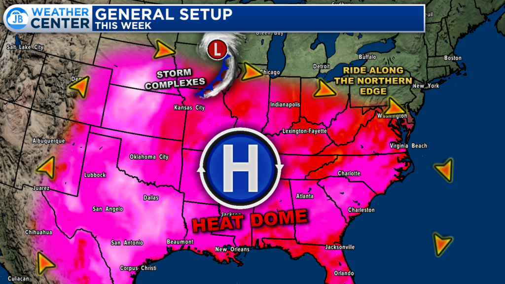
To set the stage, we have an area of high pressure developing across the southern US. This high pressure will act as a “heat dome”, bringing 90s and 100s to much of the Southeast and Great Plains. The flow around this area of high pressure is clockwise, and areas from the Great Lakes to Mid-Atlantic will be on the northern fringes of this “heat dome”
With such a stark contrast in temperatures on either side of the “heat dome” we can see storm complexes develop on the edges of them, and then ride eastward along this area of high pressure. We refer to these storm complexes as “Mesocale Convective Systems“, or “MCS” for short.
An MCS is a complex of thunderstorms that becomes organized on a scale larger than the individual thunderstorms and normally persists for several hours or more. MCSs may be round or linear in shape. We are likely to see one of these MCS complexes develop this afternoon on the northern edge of the “heat dome”.
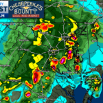
Our Chesapeake’s Bounty Futurecast shows that we are likely to see an MCS develop across eastern Iowa and western Wisconsin early this afternoon, as shown by the developing line of storms. This system will race eastward and will strengthen and organize as it does so. This MCS will work eastward, reaching peak intensity as it moves through the southern Great Lakes region this afternoon and evening.
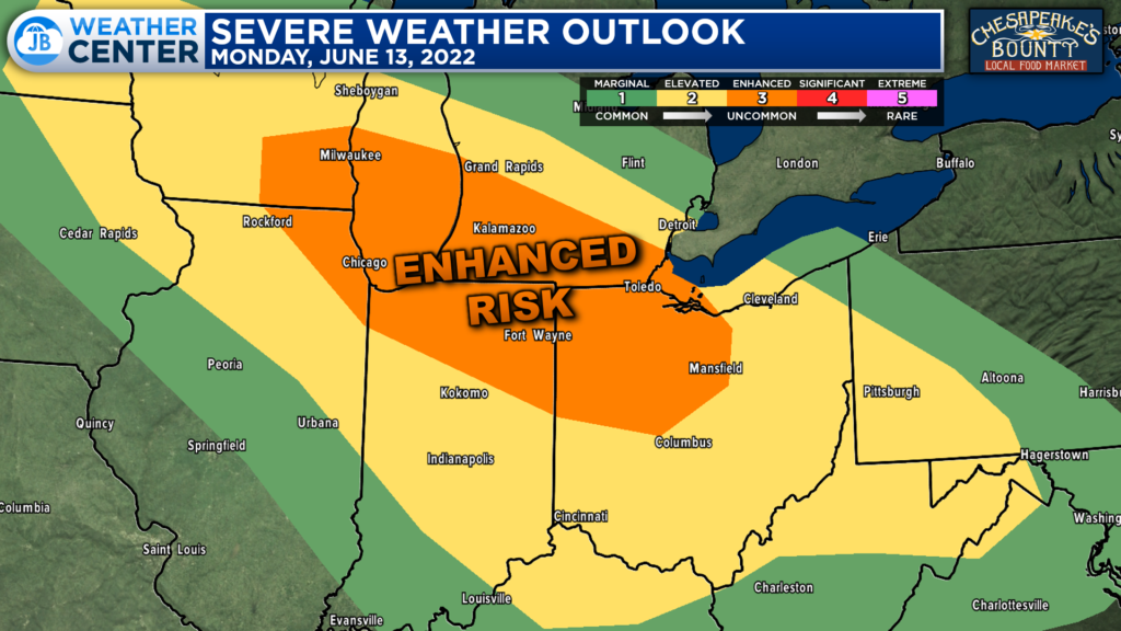
The Storm Prediction Center has already placed parts of the Great Lakes region under a Level 3 “Enhanced Risk” of severe weather for this afternoon and evening, due to the threat of this potential MCS. The primary risk that this system will bring is damaging winds between 60-70mph.
This part of the forecast makes some forecasters in our region wary. In the past, we have seen strong MCS systems make tracks like this, and bring moderate to high impacts to our region. One of the most notable times this happened was 10 years ago.
In June 2012, we saw a very strong MCS system move across the Great Lakes region and blast through our region bringing 70-90mph wind gusts and widespread power outages in the midst of a record-breaking heatwave. In post-storm analysis, the June 2012 MCS was declared to have been a derecho.
A “derecho” is a type of MCS. Derechos are a long-lived, rapidly moving line of intense thunderstorms that produces widespread damaging winds in a nearly continuous swath.
By definition, the term “derecho” applies to a complex line of thunderstorms that travels a minimum distance of 240 miles or more, and produces a nearly continuous and widespread swath of damaging winds over that distance, with concentrated areas of wind speeds over 58 mph.
The June 2012 example is a very extreme case of what a derecho is and an exceptionally rare example of an MCS. Most MCSs are not nearly as strong as the June 2012 derecho. This is similar to how Hurricane Katrina is an exceptionally rare example of what a Hurricane is.
The June 2012 derecho was a traumatizing event for our region, making many people anxious when they hear that word, or are alerted to that potential. As a result media organizations tend to prey on this anxiousness to drive up news reach. Yes, it is as despicable as it sounds.
“Derecho” is a term that has been thrown around a lot over the last 48 hours for this storm threat. Sure, this MCS is likely to bring damaging winds to the southern Great Lakes, and will take a path similar to the June 2012 derecho. However, that’s about where the similarities end. Let’s get back to the forecast.
The MCS will work through Ohio this evening. It will continue eastward and approach the Appalachian Mountains during the overnight hours. This is where a fork in the road occurs. I would say 4 times out of 5, the Appalachian Mountains will tear these systems apart, and that is what our Futurecast model has happening. With that said, there are a few occasions when these systems can survive the trip over the mountains.
If that happens this evening, this MCS may move through our region during the early morning hours of tomorrow. With limited storm energy (since the peak daytime heating would have been long gone) this line likely would not be overly strong. Sure, some showers and locally heavy downpours could be possible between 3-8am. However, this would not be like the wicked derecho of 10 years ago. And again, Futurecast has a hard time even getting this MCS over the mountains!
Nevertheless, this is something I will monitor. These forecasts can change quickly as we learn more, so we will need to stay aware. With that said, though, I have a hard time seeing this be on the magnitude of June 2012. The highest severe risk will be across the Great Lakes this afternoon and evening before generally tapering off as you get near the mountains.
Stay with JB Weather for the latest information on Southern Maryland weather. You can always access my forecasts and updates here on the website, on Facebook, on Twitter, on Instagram, and on YouTube.
-JB
1:40PM UPDATE: Much of our region has now been placed under a Level 2 “Elevated Risk” of severe weather for tomorrow morning. This comes a line of storms may try to push through between 3-8am.
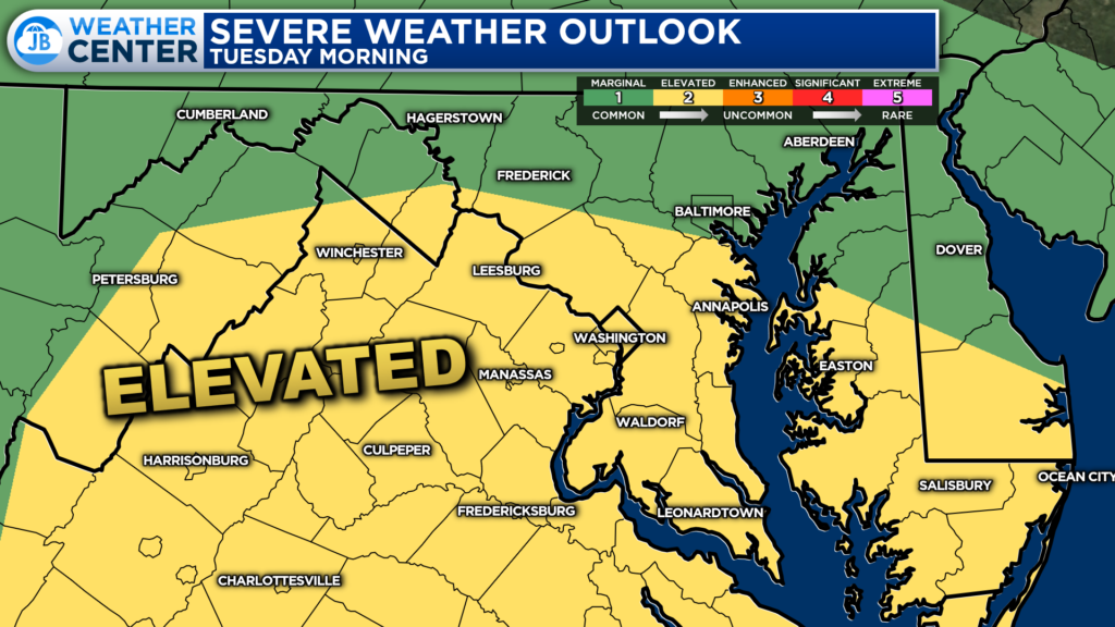
I will have more information out tonight/tomorrow morning’s forecast later this evening. In the meantime, I would suggest that you stray away from hype articles that are sounding alarms about an incoming derecho. These are similar to the 10-day snowfall maps we see every Winter. ![]()

Chesapeake’s Bounty is providing our community farm-fresh foods from the Chesapeake Bay region. Local seafood, produce, meats, dairy and more! Locations in Saint Leonard and North Beach. Make sure to stop by and also check out www.chesapeakesbounty.com
