Brought to you by All in One Tag & Title
On Tuesday, the National Oceanic and Atmospheric Administration, otherwise known as NOAA, released its initial forecast for the 2022 Atlantic Hurricane Season.
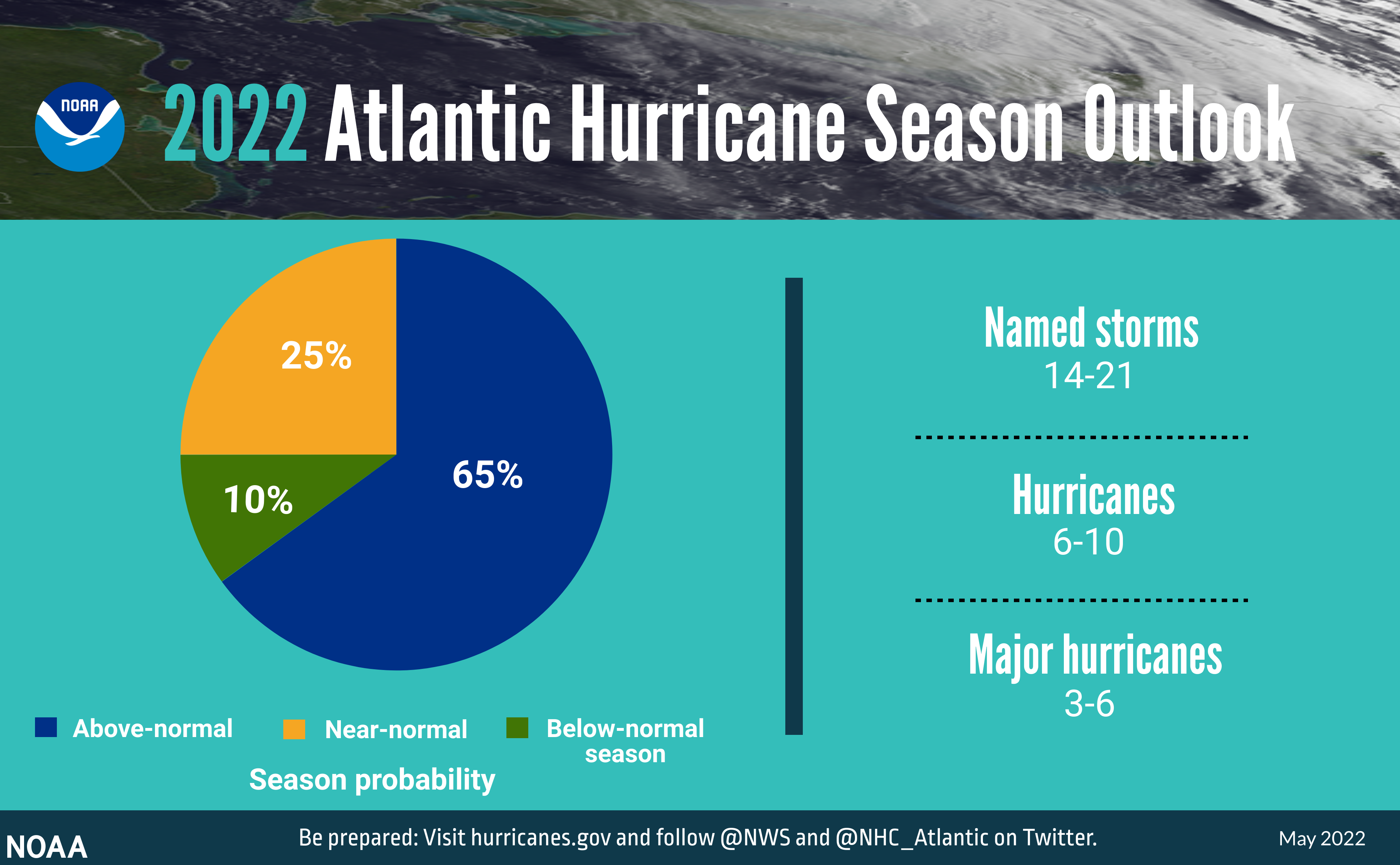
NOAA is predicting yet another above-normal Atlantic hurricane season. Forecasters predict a 65% chance of an above-normal season, a 25% chance of a near-normal season, and a 10% chance of a below-normal season.
NOAA is forecasting a likely range of 14-21 named storms (winds of 39 mph or higher), of which 6-10 could become hurricanes (winds of 74 mph or higher), including 3-6 major hurricanes (category 3, 4 or 5; with winds of 111 mph or higher). NOAA provides these ranges with a 70% confidence.
Our current seasonal averages for the Atlantic Basin, using 1991-2020 data, are 14 total Named Storms, 7 total Hurricanes, and 3 hurricanes of Category 3 strength or higher (also known as Major Hurricanes). If this forecast for above-normal activity is correct, this would be our seventh straight season in a row of above-normal activity. Shown below are the stats from the past six seasons.
| 2021 | 2020 | 2019 | 2018 | 2017 | 2016 | AVERAGE | |
|---|---|---|---|---|---|---|---|
| Named Storms | 21 | 30 (R) | 18 | 15 | 17 | 15 | 14 |
| Hurricanes | 7 | 14 | 6 | 8 | 10 | 7 | 7 |
| Major Hurricanes | 4 | 7 (R) | 3 | 2 | 6 | 4 | 3 |
This hurricane season’s increased activity can be attributed to several climate factors, including the ongoing La Niña that will likely persist throughout the hurricane season, warmer-than-average sea surface temperatures in the Atlantic Ocean and Caribbean Sea, weaker tropical Atlantic trade winds and an enhanced west African monsoon.
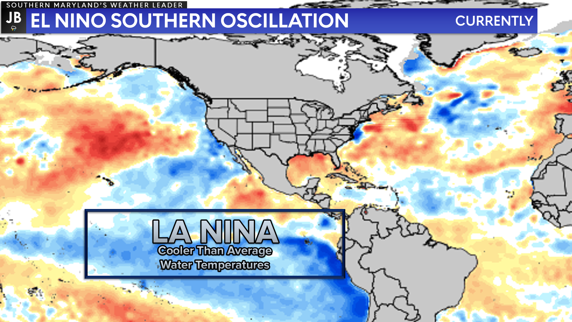
A La Niña pattern is when ocean waters in the equatorial Pacific Ocean are cooler than average. This pattern changes weather patterns across the world, including in the tropical Atlantic. In a La Niña cycle, wind shear reduces in the tropical Atlantic and stability. This results in more tropical storms and hurricanes forming, which leads to an above-average hurricane season.
Two things must be present for a hurricane to form: a weather disturbance, such as a thunderstorm that pulls in warm surface air from all directions, and water at the ocean’s surface that is at least 80° Fahrenheit. Hurricanes gain and lose wind speed based on the ocean water temperature below. It’s why they form in the tropics and break apart over cooler water and land. Widespread, persistent warm water can support increased tropical activity throughout the hurricane season.
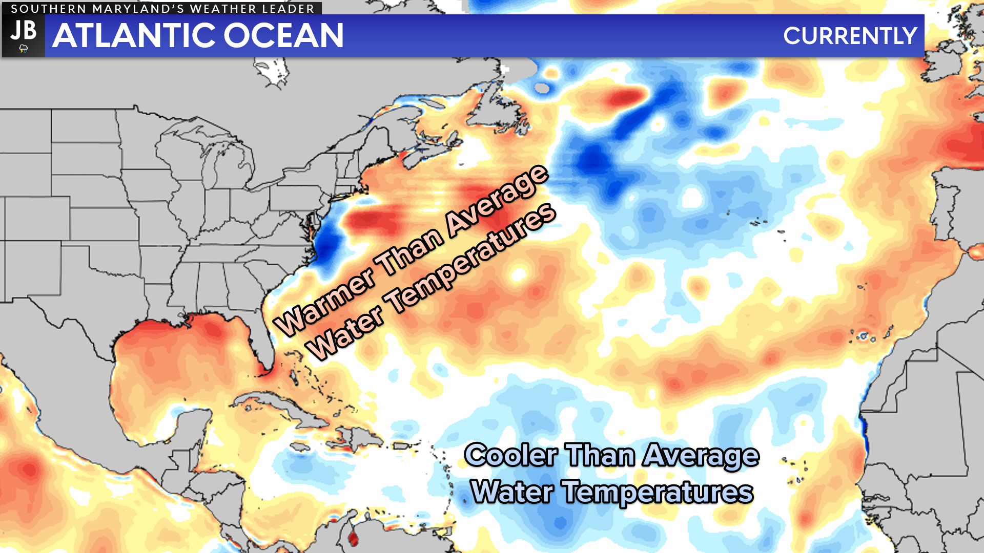
We have warmer waters across much of the Atlantic Basin this season, especially right off of the East Coast and in the Gulf of Mexico. However, we note that there is a pocket of cooler water temperatures off the coast of Africa, where many long-track hurricanes forms. This suggests that we may see an increase in “homegrown” tropical systems or tropical systems that develop and/or rapidly intensify close to the coastline. Water temperatures will continue to warm throughout the coming months across the Atlantic.
Additionally, an enhanced west African monsoon supports stronger African Easterly Waves, which seed many of the strongest and longest-lived hurricanes during most seasons. The way in which climate change impacts the strength and frequency of tropical cyclones is a continuous area of study for NOAA scientists.
It is important to note that this forecast does not represent the number of storms that could affect the coastline. There is no correlation between the number of storms or hurricanes that form and landfalls in the U.S. A quiet season can still produce a strong hurricane that makes landfall in the US. That’s why residents should prepare each year, no matter the forecast.
It will be important to stay weather aware throughout the hurricane season, which runs from June 1 to November 30.
Stay with JB Weather for the latest information on Southern Maryland weather. You can always access my forecasts and updates here on the website, on Facebook, on Twitter, on Instagram, and on YouTube.
-JB

At All In One Tag & Title, we make quick work of MVA Tag & Title Services! We are located in Owings, MD on the corner of Chaneyville Rd. Give us a call at 301-327-5081 or stop by, no appointment needed! Mention you saw us on JB Weather and get $5.00 off tag & title services. Check out www.allinonellc.net today!
John Bordash
View More PostsJB Weather forecaster John Bordash is working around the clock to provide Southern Maryland, and neighboring communities, with accurate and reliable weather information.