Brought to you by Cedar Point Federal Credit Union
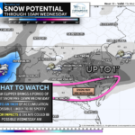
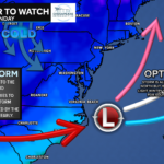
For the past week we’ve been watching the potential for a southern system to develop and track off the Southeast coast, and we’re finally within about 36 hours of the event. While confidence is increasing that most of the region sees precipitation Sunday evening (around 4 PM onward), the exact type of precipitation is still uncertain.

Right now, the most likely outcome is a cold rain for much of the area, with up to around an inch possible south of Baltimore. However, temperatures north and west of DC will be hovering near freezing. Both the American and European global models suggest snow could mix in northwest of I-95. Short-range models are less impressed with the cold air, which is why confidence remains lower than we’d normally like this close to an event.
If the colder solution verifies, even a brief window of steady snow Sunday night could put down a quick inch or two in colder northwest spots. If not, it’s mostly a chilly rain. The system should pull away by early Monday morning.
There are a lot of questions with this system! Updates to come as the picture comes into better focus!
Stay with JB Weather for the latest information on impacts here in Southern Maryland and across the Mid-Atlantic. You can always access my forecasts and updates here on the website, on Facebook, on Twitter, on Instagram, and on YouTube. JB Weather is the Mid-Atlantic’s Weather Leader, and I am working around the clock to keep you ahead of any storm!
Cedar Point has been providing trusted banking, lending and personal finance solutions to the Southern Maryland Community since 1945. Visit the credit union at any of its 6 locations in St. Mary’s, Charles and Calvert counties or online at www.cpfcu.com.
John Bordash
View More PostsJB Weather forecaster John Bordash is working around the clock to provide Southern Maryland, and neighboring communities, with accurate and reliable weather information.